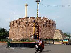
Kurnool district
| Kurnool district | |
|---|---|
| District of Andhra Pradesh | |
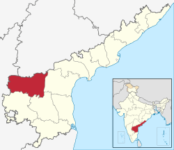 Location of Kurnool district in Andhra Pradesh | |
| Country | India |
| State | Andhra Pradesh |
| Headquarters | Kurnool |
| Government | |
| • District collector | S.Satyanarayana IAS |
| • Lok Sabha constituencies | Kurnool, Nandyal |
| • Assembly seats | 14 |
| Area | |
| • Total | 17,658 km2 (6,818 sq mi) |
| Population (2011) | |
| • Total | 4,046,601[1] |
| • Urban | 28.26% |
| Demographics | |
| • Literacy | 61.13% |
| • Sex ratio | 984 |
| Vehicle registration | AP-21 |
| Major highways | AH 43, NH 44, NH 167, NH 18 |
| Coordinates | 15°48′N 78°0′E / 15.800°N 78.000°ECoordinates: 15°48′N 78°0′E / 15.800°N 78.000°E |
| Website | Official website |
Kurnool District is one of the 13 districts in the state of Andhra Pradesh, India. The district is located in the west-central part of the state and is bounded by Mahabubnagar district of Telangana in the north, Raichur district of Karnataka in the northwest, Bellary district of Karnataka in the west, Ananthapur district in the south, YSR Kadapa district in the South East and Prakasham district in the east. The city of Kurnool is the headquarters of the district. It has a population of 4,053,463 of which 28.35% were urban as of 2011. The district is the 10th largest district in the country and the 2nd largest district in the state,[2] accounting for 17,658 square kilometres (6,818 sq mi).
History
Palaeolothic era
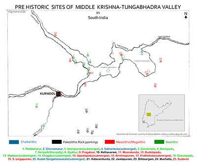
The Ketavaram rock paintings are dated back to the Paleolithic era (located at a distance of 18 km (11 mi) from Kurnool).[3] Jurreru Valley, Katavani Kunta[4] and Yaganti in the district have some important rock arts and paintings in their vicinity, which are dated back to 35,000 to 40,000 years ago.
Buddhism and Jainism
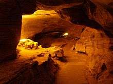
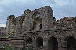
Belum Caves are geologically and historically important caves in the district. There are indications that Jain and Buddhist monks were occupying these caves centuries ago. Many Buddhists relics were found inside the caves. These relics are now housed in Museum at Ananthapur. Archaeological survey of India (ASI) found remnants of vessels and other artifacts of pre-Buddhist era and has dated the remnants of vessels found in the caves to 4500 BC.[5]
Modern era
Neelam Sanjeeva Reddy (Ananthapur District), the 6th President of India has served as Member of Parliament from Nandyal constituency. He previously served as the Chief Minister of Andhra Pradesh, serving as an MLA from the Dhone assembly constituency. In 1970, part of Kurnool district was split off to become part of Prakasam district.[6] Kurnool District is a part of the Red Corridor.[7]
Geography

Kurnool district occupies an area of approximately 17,658 square kilometres (6,818 sq mi),[8] comparatively equivalent to New Caledonia.[9] Kurnool is surrounded by districts of Mahbubnagar district of Telangana to the north, Anantapur district, Kadapa district to south, Prakasam district to east and Bellary of Karnataka to the west. The district encompasses the Srisailam Dam and Nallamala Hills.
Demographics
According to the 2011 census Kurnool district has a population of 4,046,601,[10] roughly equal to the nation of Liberia[11] or the US state of Oregon.[12] This gives it a ranking of 54th in India (out of a total of 640).[10] The district has a population density of 229 inhabitants per square kilometre (590/sq mi) .[10] Its population growth rate over the decade 2001-2011 was 14.65%.[10] Kurnool has a sex ratio of 984 females for every 1000 males,[10] and a literacy rate of 61.13%.[10]
Household indicators
In 2007–2008 the International Institute for Population Sciences interviewed 1247 households in 38 villages across the district.[14] They found that 94% had access to electricity, 89.7% had drinking water, 34.6% toilet facilities, and 51.6% lived in a pucca (permanent) home.[14] 30.6% of girls wed before the legal age of 18[15] and 85.1% of interviewees carried a BPL card.[14]
Divisions
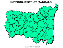
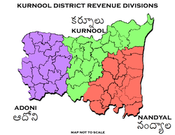
Kurnool District has 3 Revenue Divisions viz., Kurnool, Nandyal, Adoni divisions.[16] The district has 54 mandals and 53 Panchayat Samitis (Blocks) under these revenue divisions. It also has a Municipal Corporation of Kurnool and 4 municipalities namely, Nandyal, Adoni, Yemmiganur and Dhone.[17] There are 899 gram panchayats that include 7 notified and 862 non-notified, alongside 920 revenue villages and 615 hamlets.[18]
Mandals
The mandals are listed with respect to their revenue divisions in the following table:[19]
Kurnool District has 3 Revenue Divisions viz., Kurnool, Nandyal, Adoni divisions.
Source:
Economy
The Gross District Domestic Product (GDDP) of the district is ₹34,359 crore (US$4.8 billion) and it contributes 6.5% to the Gross State Domestic Product (GSDP). For the FY 2013-14, the per capita income at current prices was ₹68,197 (US$950). The primary, secondary and tertiary sectors of the district contribute ₹12,035 crore (US$1.7 billion), ₹6,055 crore (US$840 million) and ₹16,269 crore (US$2.3 billion) respectively.[22]
Transport
The total of core road network of the district is 1,162.20 km (722.16 mi). It includes, 504.48 km (313.47 mi) of existing and a proposed length of 657.720 km (408.688 mi).[23]
Education
The primary and secondary school education is imparted by government, aided and private schools, under the School Education Department of the state.[24][25] As per the school information report for the academic year 2015-16, there are a total of 4,179 schools. They include, 78 government, 2,398 mandal and zilla parishads, 1 residential, 1,355 private, 33 model, 53 Kasturba Gandhi Balika Vidyalaya (KGBV), 140 municipal and 121 other types of schools.[26] The total number of students enrolled in primary, upper primary and high schools of the district are 631,740.[27]
References
- ↑ {{cite web|title=Anantapur district profile l=http://www.ap.gov.in/Pages/Districts.aspx |publisher=Andhra Pradesh State Portal |archivedate=15 July 2014 |deadurl=yes |archiveurl=https://web.archive.org/web/20140715100812/http://www.ap.gov.in/Pages/Districts.aspx |df}}
- ↑ "Top 10 Largest Districts of India by Total Area". census2011.co.in.
- ↑ "archelogical excavations" (PDF). aparchaeologymuseum. Archived from the original (PDF) on 17 December 2013. Retrieved 15 June 2014.
- ↑ Michael Petraglia. "New rock art discoveries in the Kurnool District, Andhra Pradesh, India". academia.edu.
- ↑ Show Caves of India: Belum Caves
- ↑ Law, Gwillim (25 September 2011). "Districts of India". Statoids. Retrieved 11 October 2011.
- ↑ "83 districts under the Security Related Expenditure Scheme". IntelliBriefs. 11 December 2009. Retrieved 17 September 2011.
- ↑ Srivastava, Dayawanti, ed. (2010). "States and Union Territories: Andhra Pradesh: Government". India 2010: A Reference Annual (54th ed.). New Delhi, India: Additional Director General, Publications Division, Ministry of Information and Broadcasting (India), Government of India. pp. 1111–1112. ISBN 978-81-230-1617-7.
- ↑ "Island Directory Tables: Islands by Land Area". United Nations Environment Program. 18 February 1998. Retrieved 11 October 2011.
New Caledonia (main island) 16,648km2
- 1 2 3 4 5 6 "District Census 2011". Census2011.co.in. 2011. Retrieved 30 September 2011.
- ↑ US Directorate of Intelligence. "Country Comparison:Population". Retrieved 1 October 2011.
Liberia 3,786,764 July 2011 est.
- ↑ "2010 Resident Population Data". U. S. Census Bureau. Archived from the original on 19 October 2013. Retrieved 30 September 2011.
Oregon 3,831,074
- ↑ "Andhra Pradesh State Minorities Finance Corporation Ltd. - Downloads". apsmfc.com.
- 1 2 3 "District Level Household and Facility Survey (DLHS-3), 2007-08: India. Andhra Pradesh" (PDF). International Institute for Population Sciences and Ministry of Health and Family Welfare. 2010. Retrieved 3 October 2011.
- ↑ "How Do I? : Obtain Marriage Certificate". National Portal Content Management Team, National Informatics Centre. 2005. Retrieved 3 October 2011.
To be eligible for marriage, the minimum age limit is 21 for males and 18 for females.
- ↑ "Brief Industrial Profile of Kurnool District" (PDF). The office of Development Commissioner (MSME), Ministry of Micro, Small & Medium Enterprises. p. 4. Retrieved 4 November 2014.
- ↑ "Part-I State Administrative Divisions 2001-2011" (PDF). Census of India. pp. 359–366. Retrieved 18 January 2015.
- ↑ "District Profile". Kurnool District Official website. Archived from the original on 11 November 2014. Retrieved 20 March 2016.
- ↑ "District Census Handbook - Kurnool" (PDF). Census of India. p. 12. Retrieved 18 January 2015.
- ↑ M.C., Obulesu (2006). Total literacy campaign : with special reference to adult drop-outs. New Delhi: D.P.H. Discovery Publishing House. pp. 70–72. ISBN 978-81-8356-056-6. Retrieved 4 November 2014.
- ↑ "Mandals in Kurnool district". aponline.gov.in. Archived from the original on 28 July 2015. Retrieved 16 September 2014.
- ↑ "Economy of Kurnool District". Andhra Pradesh Economic Development Board. Retrieved 25 April 2017.
- ↑ ":: APRDC ::". Andhra Pradesh Road Development Corporation. Roads and Buildings Department. Retrieved 9 November 2016.
- ↑ "School Education Department" (PDF). School Education Department, Government of Andhra Pradesh. Archived from the original (PDF) on 27 December 2015. Retrieved 7 November 2016.
- ↑ "The Department of School Education - Official AP State Government Portal". www.ap.gov.in. Archived from the original on 7 November 2016. Retrieved 7 November 2016.
- ↑ "School Information Report". Commissionerate of School Education. Government of Andhra Pradesh. Retrieved 8 November 2016.
- ↑ "Student Information Report". Commissionerate of School Education. Child info 2015-16, District School Education - Andhra Pradesh. Retrieved 8 November 2016.
External links
| Wikimedia Commons has media related to Kurnool district. |
Places adjacent to Kurnool district | |
|---|---|
| District headquarters |  | |
|---|---|---|
| Divisions | ||
| Mandals | ||
| Cities | ||
| Towns | ||
| Census towns | ||