Nellore
| Nellore Vikramasimhapuri | |
|---|---|
| City | |
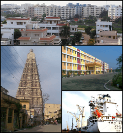 Nellore Montage Clockwise from top left: Nellore City View, Narayana Colleges, A Ship at Krishnapatnam Port, Gopuram of Sri Ranganathaswamy Temple, Nellore | |
| Nickname(s): nallauru | |
 Nellore Nellore | |
| Coordinates: 14°27′N 79°59′E / 14.45°N 79.99°ECoordinates: 14°27′N 79°59′E / 14.45°N 79.99°E | |
| Country | India |
| State | Andhra Pradesh |
| Region | Coastal Andhra |
| District | Nellore |
| Government | |
| • Type | Mayor-council |
| • Body | Nellore Urban Development Authority |
| • Mayor | Abdul Aziz |
| Area[1][2] | |
| • Total | 149.02 km2 (57.54 sq mi) |
| Elevation | 18 m (59 ft) |
| Population (2011)[1][3] | |
| • Total | 600,869 |
| • Rank |
75th (India) 4th (Andhra Pradesh) |
| • Density | 4,000/km2 (10,000/sq mi) |
| Languages | |
| • Official | Telugu |
| Time zone | UTC+5:30 (IST) |
| PIN | 524 001 |
| Telephone code | +91–861 |
| Vehicle registration | AP–26, AP-28, AP-29 |
Nellore is a city and district headquarters of Nellore district in the Indian state of Andhra Pradesh. It is located on the banks of Penna River[4] and is the fourth most populous city in the state.[5]
Etymology
A mythological story from Sthala Purana depicts, a lingam in the form of a stone under nelli tree. The place gradually became Nelli-ooru ("Nelli chettu" in Telugu stands for emblica Tree and ooru in Telugu stands for place) and then to present day Nellore.[6][7]
History
Nellore had been under the rule of Cholas, Pallavas, pandyas, Maurya Dynasty, Kharavela of Chedi dynasty, Satavahanas, Kakatiyas, Eastern Gangas of Kalinga Empire, Vijayanagara Empire, Arcot Nawabs and other dynasties.
Nellore existed from the times of the Cholas ruled by Rajendra Chola I under Tanjavur Mauryan empire and was ruled by Ashoka in the 3rd century B.C. Nellore was conquered by the Rulers of the Pallava Dynasty and it was under their till the 6th century AD, subsequently the Chola rulers ruled Nellore for a long period of time. The Telugu Cholas met their decline in the 13th Century.Tamil inscriptions indicate that it formed part of Chola kingdom till their decline in the thirteenth century AD[8] It later became a part of Kakatiyas, Vijayanagara Empire, Sultanate of Golconda, Mughal Empire and Arcot Nawabdom. In the 18th century, Nellore was taken over by the British from the Arcot Nawabs and was part of the Madras Presidency of British India.
The city had an important role in the emergence of the Telugu language and the formation of the state of Andhra Pradesh. Potti Sriramulu, who fasted until death for the formation of Andhra Pradesh, hailed from Nellore.
Geography
Nellore is located at 14°26′N 79°59′E / 14.44°N 79.98°E.[9][10] It has an average elevation of 18 metres (59 ft).[10]
Climate
The climate of Nellore city is a typical tropical maritime climate, with hot, humid summers and mild winters. April and May are the hottest months and the hot conditions generally last until the end of the June. December, January and February are the coolest months. As the Bay of Bengal is at a distance of 24 kilometres (15 mi) from the city, the sea breeze renders the climate of the city moderate both in winter and in summer. Humidity level in the city is high due to its proximity to the coast. Nellore does not receive the south-west monsoon. Rainfall in Nellore occurs between the months of October and December due to the north-east monsoon. This period gives about 60 percent of the city's annual rainfall. Cyclones are common in the city during this period, causing floods and havoc.[11]
The maximum temperature is 36 to 46 °C (97 to 115 °F) during summer and the minimum temperature is 23 to 25 °C (73 to 77 °F) during winter. The rainfall ranges from 700 to 1,000 mm (28 to 39 in) through South West and North East Monsoons. Nellore is subject both to droughts and to floods based on the seasons. It is also one of the hottest cities in India with at least 35 super hot days in a year.[12]
| Climate data for Nellore (1981–2010) | |||||||||||||
|---|---|---|---|---|---|---|---|---|---|---|---|---|---|
| Month | Jan | Feb | Mar | Apr | May | Jun | Jul | Aug | Sep | Oct | Nov | Dec | Year |
| Record high °C (°F) | 35.6 (96.1) |
39.4 (102.9) |
43.9 (111) |
45.6 (114.1) |
46.7 (116.1) |
46.7 (116.1) |
42.2 (108) |
40.6 (105.1) |
41.7 (107.1) |
39.4 (102.9) |
36.7 (98.1) |
35.0 (95) |
46.7 (116.1) |
| Average high °C (°F) | 29.9 (85.8) |
32.4 (90.3) |
35.1 (95.2) |
37.8 (100) |
39.9 (103.8) |
38.2 (100.8) |
36.0 (96.8) |
35.1 (95.2) |
35.1 (95.2) |
32.8 (91) |
30.1 (86.2) |
29.0 (84.2) |
34.3 (93.7) |
| Average low °C (°F) | 20.7 (69.3) |
22.0 (71.6) |
23.9 (75) |
26.2 (79.2) |
28.4 (83.1) |
28.5 (83.3) |
27.2 (81) |
26.7 (80.1) |
26.4 (79.5) |
25.2 (77.4) |
23.2 (73.8) |
21.5 (70.7) |
25.0 (77) |
| Record low °C (°F) | 15.0 (59) |
16.1 (61) |
17.2 (63) |
20.2 (68.4) |
20.2 (68.4) |
21.1 (70) |
22.2 (72) |
21.7 (71.1) |
21.5 (70.7) |
18.9 (66) |
16.7 (62.1) |
14.4 (57.9) |
14.4 (57.9) |
| Average precipitation mm (inches) | 26.0 (1.024) |
1.7 (0.067) |
3.5 (0.138) |
8.7 (0.343) |
43.1 (1.697) |
28.9 (1.138) |
85.9 (3.382) |
96.0 (3.78) |
97.2 (3.827) |
287.1 (11.303) |
290.9 (11.453) |
100.4 (3.953) |
1,069.4 (42.102) |
| Average precipitation days | 1.2 | 0.2 | 0.2 | 0.4 | 1.6 | 3.0 | 6.1 | 6.4 | 5.4 | 8.7 | 9.1 | 3.7 | 46.0 |
| Source: India Meteorological Department (record high and low up to 2010)[13][14] | |||||||||||||
Demographics
As of 2011 census, Nellore city had a population of 499,576. The average literacy rate stands at 83.59% (male 87.53%; female 79.52%) with 387,192 literates, significantly higher than the state average of 73.00%.[16][17] The expanded city population post merger of 15 gram panchayats into Nellore Municipal Corporation stands at 600,869.[5][18]
| Year | Population | Growth Rate |
|---|---|---|
| 1961 | 106776 | --- |
| 1971 | 133590 | 25.1 |
| 1981 | 237065 | 77.5 |
| 1991 | 316606 | 33.6 |
| 2001 | 404775 | 27.8 |
| 2011 | 600869 | 48.4 |
Governance
Civic administration
Nellore Municipal Corporation was constituted as a municipality on 1 November 1866 by the Madras District Municipality Act.[20][21] It was upgraded to corporation on 18 October 2004 and has a jurisdictional area of 150.48 km2 (58.10 sq mi) with 54 wards.[1] In 2013, fifteen gram panchayats namely, Allipuram, Ambhapuram, Buja Buja Nellore, Chinthareddypalem, Gudupallipadu, Gundlapalem, Kallurupalli, Kanaparthypadu, Kodurupadu, Narayanareddypeta, Navalakulathota, Nellore Bit-I (Kothuru), Peddacherukuru, Pottipalem, Vavilatepadhu were merged into the municipal corporation.[22] Present mayor of the city is Abdul Aziz.[23]
The city is one among the 31 cities in the state to be a part of water supply and sewerage services mission known as Atal Mission for Rejuvenation and Urban Transformation (AMRUT).[24]
Politics
Nellore is represented by Nellore City assembly constituency and Nellore Rural assembly constituency for Andhra Pradesh Legislative Assembly. Anil Kumar Poluboina is the present MLA of Nellore City assembly constituency representing YSRCP.[25] Kotamreddy Sridhar Reddy is the present MLA of Nellore Rural assembly constituency representing YSRCP.[26][27] Nedurumalli janardhan reddy former chief minister of combined andhra pradesh hails from this place.
Economy
Certain industries like Nippo batteries factory, Apache leather shoes factory etc. have their presence. Proximity to the sea and fertile land towards the east have led to agriculture and aquaculture to prosper. The most productive is the Shrimp culturing.[28]
Culture
The annual Rottela Panduga/Rotiyaan ki Eid is an annual urs event celebrated at the Bara Shaheed Dargah(shrine of twelve martyrs) on the banks of Swarnala Cheruvu.[29] The event got its name after the practice of exchanging rotis(flat breads) and attracts visitors from all religious backgrounds.[30] It is also the home for various temples. Famous temples such as Sri Ranganayaka Swamy Temple exist in the heart of the city. Nellore has got many clubs such as Rotary club where one can spend time reading newspapers or playing board games. Nellore is famous for a dish made out of fish known as 'Nellore Fish Pulusu'.
Economy
A 12,000 acre Special Economic Zone (SEZ) is being set up in the vicinity of the port by the Krishnapatnam Infratech Private Limited, a special purpose vehicle set up by KPCL. The SEZ entails an investment of ₹6,000 crores and is expected to create 30,000 direct employments.[31] The SEZ is being designed by Mahindra Engineering and is to be a multi-product SEZ.[32]
Transport

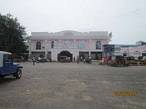
Local transport in the city include, two, three and four wheelers.[33] Of these, privately operated auto rickshaws accounts to around 6,000, dominating most part of the city for local commuting.[34] Nellore bus station of the city operates district and long distance services.[35] Nellore is classified as an A grade and Adarsh station in the Vijayawada railway division of South Central Railway zone.[36] The city also has three small railway stations namely, Nellore South,[37] Vedayapalem.[38] and Padugupadu railway station The Southern Railway operates MEMUs for commuting between Nellore and Chennai Central.[39] There is also a proposal to build a no frills airport for the city.[40]
The city has a total road length of 1,189.95 km (739.40 mi).[41] The proposed Outer Ring Road, existing arterial and internal roads helps reduce traffic congestion.[34] The city is connected with major National highways such as, National Highway 16, a part of Asian Highway 45 and Golden Quadrilateral, bypasses the city.[42]
Education
The primary and secondary school education is imparted by government, aided and private schools of the School Education Department of the state.[43][44] The medium of instruction followed by different schools are English, Telugu.[45] Narayana medical college, venkata raja college(vrc) are famous and prestigious institutions. Narayana educational institutions have first started here. It's home for so many intermediate colleges which attracts students from kadapa and chittor districts.
Media
Zaminryot[46] newspaper and Lawyer weekly newspaper[47] are based out of Nellore. In addition, Eenadu,Vaartha AndhraJyothy and Sakshi newspapers are also printing local editions in Nellore. Deccan Chronicle has also launched their Nellore edition in April 2003 and it is the first English paper to be published from Nellore.
Notable People
S.P.Balasubramanyam, a playback singer.
Vanisri, an actress.
See also
- List of cities in Andhra Pradesh by population
- List of municipal corporations in India#Andhra Pradesh
- list of beaches near nellore
References
- 1 2 3 "Municipality Profile". Nellore Municipal Corporation. Retrieved 18 May 2017.
- ↑ Ravikiran, G. "Fertile lands turning into concrete jungle". The Hindu. Retrieved 18 May 2017.
- ↑ "Integrated Municipal Solid Waste (MSW) Management Project" (PDF). Swachha Andhra Corporation. Government of Andhra Pradesh. p. 20/4. Retrieved 31 October 2016.
- ↑ Ravikiran, G. "Lakhs celebrate 'gobbemma festival'". The Hindu. Retrieved 18 May 2017.
- 1 2 "District Census Handbook – Sri Potti Sriramulu Nellore" (PDF). Census of India. p. 12,25–26,56. Retrieved 14 November 2015.
- ↑ Staff, Government Of Madras; Madras, Government of. Gazetteer of the Nellore District: Brought Upto 1938. Asian Educational Services. p. 3. ISBN 9788120618510. Retrieved 26 May 2017.
- ↑ te:తెలుగు-ఇంగ్లీషు నిఘంటువు (న)
- ↑ (1908) The Imperial Gazetteer of India. Volume 19. Nayakanhatti to Parbhani. Clarendon Press. p. 9
- ↑ "Latitude and Longitude of Nellore, Andhra Pradesh | Nellore Coordinates". www.mapsofindia.com. Retrieved 25 March 2016.
- 1 2 "Maps, Weather, and Airports for Nellore, India". fallingrain.com.
- ↑ "Welcome to Nellore". ap.nic.in. Archived from the original on 31 January 2015.
- ↑ "Why India is getting hotter by the year". Rediff. 26 May 2015.
- ↑ "Nellore Climatological Table Period: 1981–2010". India Meteorological Department. Retrieved 27 May 2015.
- ↑ "Ever recorded Maximum and minimum temperatures up to 2010" (PDF). India Meteorological Department. Archived from the original (PDF) on 21 May 2013. Retrieved 27 May 2015.
- ↑ "Census of India – Socio-cultural aspects". Government of India, Ministry of Home Affairs. Archived from the original on 20 May 2011. Retrieved 2 March 2011.
- ↑ "Cities having population 1 lakh and above" (PDF). Office of the Registrar General & Census Commissioner, India. Retrieved 26 March 2012.
- ↑ "Literacy of AP (Census 2011)" (PDF). AP govt. portal. p. 43. Archived from the original (PDF) on 14 July 2014. Retrieved 11 June 2014.
- ↑ "Smart wards: Nellore woos industrialists". The Hindu. Nellore. 26 January 2015. Retrieved 25 August 2015.
- ↑ "INTEGRATED MUNICIPAL SOLID WASTE (MSW) MANAGEMENT PROJECT FOR ZONE-IV OF ANDHRA PRADESH" (PDF). Retrieved 10 Nov 2016.
- ↑ Ravikiran, G. (1 April 2014). "Fertile lands turning into concrete jungle". The Hindu. Retrieved 31 October 2016.
- ↑ "Municipalities, Municipal Corporations & UDAs" (PDF). Directorate of Town and Country Planning. Government of Andhra Pradesh. Retrieved 29 January 2016.
- ↑ "SPSR NELLORE-District Panchayat". www.nellorzp.appr.gov.in. Retrieved 31 October 2016.
- ↑ Ravi Kiran, G (12 April 2015). "Civic body gears up to tackle water woes". Th Hindu. Nellore. Retrieved 30 April 2015.
- ↑ Vadlapatla, Sribala (11 August 2015). "Amaravati among 31 AP cities selected for Amruth development". The Times of India. Hyderabad. Retrieved 18 December 2015.
- ↑ "Nellore City Assembly 2014 Election Results". Elections.in. Retrieved 14 October 2014.
- ↑ "MLA". AP State Portal. Retrieved 14 October 2014.
- ↑ "Nellore City Assembly 2014 Election Results". Elections.in. Retrieved 14 October 2014.
- ↑ "History of Nellore". Nellore Municipal Corporation. Archived from the original on 17 November 2015. Retrieved 14 November 2015.
- ↑ G. Ravikiran. "'Rottela Panduga' from Nov. 4 in Nellore". The Hindu.
- ↑ G. Ravikiran. "2 lakh devotees throng Bara Shahid dargah". The Hindu.
- ↑ "Krishnapatnam Port plans SEZ". Business Standard. March 2, 2010. Retrieved 22 November 2012.
- ↑ "Krishnapatnam Infratech Private Limited". Retrieved 22 November 2012.
- ↑ "'Growing number of vehicles cause of traffic chaos in Nellore'". The Hindu. Nellore. 13 February 2017. Retrieved 4 July 2017.
- 1 2 "ORR proposed for Nellore to decongest city traffic". The Hans India. Retrieved 4 July 2017.
- ↑ "Bus stations across AP to be linked to PNBS". The Hindu. Retrieved 4 July 2017.
- ↑ "Vijayawada Division – a profile" (PDF). Indian Railways. Retrieved 13 February 2013.
- ↑ "Railways will help develop AP". The Hans India. Retrieved 4 July 2017.
- ↑ "Nellore South Railway Station". Indian Railways Trains & Stations – India Rail Info. Retrieved 18 July 2015.
- ↑ "The Hindu : Nellore-Central MEMU services from tomorrow". The Hindu. Chennai. 8 November 2002. Retrieved 4 July 2017.
- ↑ Reddy, B. Dasarath (25 December 2015). "Traffic rise in old airports gives a boost to Andhra's plan to build 6 new runways". Business Standard India. Retrieved 24 May 2017.
- ↑ "Details of Roads in each ULB of Andhra Pradesh". Municipal Administration and Urban Development Department. Archived from the original on 1 August 2016. Retrieved 27 June 2016.
- ↑ "NHAI Under Pressure to Lay Another Bypass Road". The New Indian Express. 25 August 2014. Retrieved 4 June 2016.
- ↑ "School Education Department" (PDF). School Education Department, Government of Andhra Pradesh. Archived from the original (PDF) on 27 December 2015. Retrieved 7 November 2016.
- ↑ "The Department of School Education – Official AP State Government Portal | AP State Portal". www.ap.gov.in. Archived from the original on 7 November 2016. Retrieved 7 November 2016.
- ↑ "Nellore Municipal Corporation school outshines corporate". Deccan Chronicle. 23 June 2015. Retrieved 9 November 2016.
- ↑ "Zaminryot". www.zaminryot.com. Retrieved 24 March 2016.
- ↑ "హోం పేజి". Lawyer Telugu Weekly. Retrieved 24 March 2016.
External links
| Wikimedia Commons has media related to Nellore. |