Srikakulam district
| Srikakulam district | |
|---|---|
| District of Andhra Pradesh | |
 Location of Srikakulam district in Andhra Pradesh | |
| Country | India |
| State | Andhra Pradesh |
| Headquarters | Srikakulam |
| Tehsils | 37[1] |
| Government | |
| • Lok Sabha constituencies | Srikakulam (Lok Sabha constituency) |
| • Assembly seats | 10 |
| Area | |
| • Total | 5,837 km2 (2,254 sq mi) |
| Population (2011) | |
| • Total | 2,699,473[2] |
| • Urban | 16.16% |
| Demographics | |
| • Literacy | 62.30% |
| • Sex ratio | 1014 |
| Vehicle registration | AP-30 |
| Major highways | NH-5 |
| Coordinates | 18°25′N 84°01′E / 18.417°N 84.017°ECoordinates: 18°25′N 84°01′E / 18.417°N 84.017°E |
| Website | [Srikakulam district website Official website] |
Srikakulam district is one of thirteen districts in the Indian state of Andhra Pradesh. It is one of the nine coastal districts, located in the extreme northeastern direction of the state. The headquarters of the district is at Srikakulam.[1] It was formerly known as Chicacole.

Geography
It is within the geographic coordinates of 18°-20’ and 19°-10’ N and 83°-50’ and 84°-50’ E. The district is skirted to a distance by Kandivalasagedda, Vamsadhara and Bahuda at certain stretches of their courses while a line of heights of the great Eastern Ghats run from the northeast. Vizianagaram district flanks in the south and west while Odisha bounds it on the north and Bay of Bengal on the East. This is the only district in Andhra Pradesh with two rivers: Nagavali and Vamsadhara.
History

Prehistory
Evidence of early historic man and his activities during the Stone Age and Iron Age have been discovered at Sangamayya Konda and Dannanapeta. The speciality of Dannanapeta Iron Age megalithic site is a large single capstone as a dolmen with 36 ft in length and 14 ft in width and 2 ft thickness. Sailada Hills consists of 36 upright rocks and natural caves used for habitation by Iron Age man in Amudalavalasa mandal of the district.[3]
Jainism and Buddhism
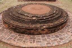
Evidences of Jain monuments and Buddhist remnants were discovered near Sangamayya Konda. Jain rock beds were discovered at Dannanapeta near Amudalavalasa in the district. Salihundam is a famous Buddhist remnants site on the south bank of River Vamsadhara 5 kilometres west of Kalingapatnam and 18 kilometres from Srikakulam town.[4]
Post Independence
Srikakulam District was carved out in 1950 by bifurcating it from Visakhapatnam District. It remained unaffected in its territorial jurisdiction for some time. But in November 1969 the district lost 63 villages from Saluru Taluk and 44 villages from Bobbili Taluk on account of their transfer to the then newly constituted Gajapathinagaram Taluk of Visakhapatnam District.
In May 1979, the district underwent major territorial changes with the formation of a new district with headquarters at Vizianagaram which involved transfer of Salur, Bobbili, Parvathipuram and Cheepurupalli Taluks to the new district. Srikakulam's culture is a blend of traditional festivals, food, music and theatres.[5]
Geography


Srikakulam district occupies an area of 5,837 square kilometres (2,254 sq mi),[6] comparatively equivalent to Australia's Melville Island.[7]
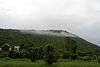
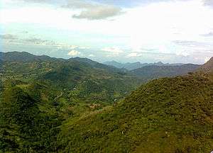
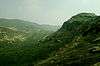
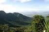
Srikakulam district can be divided into two main distinct natural divisions. A portion of Srikakulam district is plain terrain with intense agriculture and the other is rocky and hilly terrain covered with forests. Some of the Mahendragiri Hills covers Srikakulam district. Most of the forest area of the plain terrain has been damaged by intense agriculture. Kotthuru, Hiramandalam, Pathapatnam, Kalingadal reservoir and some other areas are still covered with dense forests.
Srikakulam is 100 km (62 mi) north of Visakhapatnam. It has a population of 2,537,593 of which 10.98% is urban as of 2001.
Srikakulam district has the longest coastline (about 193 km (120 mi)) in the state of Andhra Pradesh. It is bordered by Odisha on the north, Vizianagaram district on the west and south, Bay of Bengal on the east.
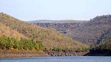
Major rivers flowing through the district are River Nagavali, River Vamsadhara, Mahendratanaya, Champavati, Bahuda, Kumbhikota Gedda, Suvarnamukhi, Vegavati, Gomukhi.
The Nagavali and Vamsadhara are the major rivers in Srikakulam district. These two river basins together constitute about 5% of the area. The Mahendratanaya and Bahuda rivers are two minor river basins in the district. Others are Benjigedda, Peddagedda, Kandivalasa gedda. Major irrigation projects on these rivers — Vamsadhara Project, Narayanapuram Anicut, Thotapalli Regulator — and some medium projects at Pydigam Project, Onigadda provide a total ayacut of 69,373 acres (280.74 km2).
Demographics
According to the 2011 census Srikakulam district has a population of 2,699,471,[8] roughly equal to the nation of Kuwait[9] or the US state of Nevada. This gives it a ranking of 147th in India (out of a total of 640).[8] The district has a population density of 462 inhabitants per square kilometre (1,200/sq mi).[8] Its population growth rate over the decade 2001-2011 was 6.38%.[8] Srikakulam has a sex ratio of 1014 females for every 1000 males,[8] and a literacy rate of 62.3%.[8]
Household indicators
According to 2007–08, International Institute for Population Sciences,[10] 86.9% had access to electricity, 70.4% had drinking water, 18.5% toilet facilities, and 47.2% lived in a pucca (permanent) home.[10] 31.5% of girls wed before the legal age of 18 and 90.1% of interviewees carried a BPL card.[10]
Divisions
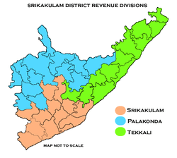
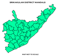
The district has three revenue divisions — Srikakulam, Palakonda and Tekkali. They are divided into 38 mandals in the district. The district has 12 towns and 1,802 villages. There are one municipal corporation, three municipalities, one nagar panchayat and seven census towns. The municipal corporation in the district is Srikakulam and three municipalities in the district are Amadalavalasa, Ichchapuram, Palasa-Kasibugga, and nagar panchayats of Palakonda, Rajam. The six census towns are Balaga, Hiramandalam, Narasannapeta, Ponduru, Sompeta, Tekkali.[11][12]
Mandals
The 38 mandals in Srikakulam district under three revenue divisions are listed in the following table:[12]
Parliamentary and Assembly constituencies
There are three Parliamentary Constituencies and 10 assembly constituencies in Srikakulam district. Parliamentary constituencies include Srikakulam, Araku, and Vizianagaram.[13]
The 10 Assembly Constituencies are Amadalavalasa, Rajam, Tekkali, Ichchapuram, Palasa, Narasannapeta, Palakonda, Pathapatnam, Srikakulam and Etcherla.
Economy

The gross district domestic product (GDDP) of the district is ₹19,942 crore (US$2.8 billion) and it contributes 3.8% to the gross state domestic product (GSDP). For FY 2013-14, the per capita income at current prices was ₹57,174 (US$800). The primary, secondary and tertiary sectors of the district contribute ₹4,855 crore (US$680 million), ₹4,114 crore (US$570 million) and ₹10,973 crore (US$1.5 billion) respectively.[14]
Tribal communities such as the Saora and Jatapus still practise the traditional podu system of cultivation.[15]
Dr. Reddy's Laboratories, a major pharmaceutical company, is at Pydibhimavaram.
Transport
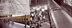
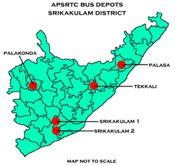
Andhra Pradesh State Road Transport Corporation runs bus services to all the major cities and towns of the state from the district. Major railway stations in the district include Amudalavalasa, Srikakulam Road railway station, Palasa railway station ( major station) Naupada, Ichchapuram and Sompeta etc. The nearest airport is Visakhapatnam which is 100 km from the city.
Culture
The district is renowned for the brassware products namely, Budithi Bell and Brass Craft, which are made at Budithi village. These are registered as geographic indication from Andhra Pradesh.[16]
The district has many people from fields like film industry, music, art and architecture etc. Among the notable people are Vaddadi Papaiah, J. V. Somayajulu, Gidugu Venkata Ramamoorty, Sarat babu, LV Revanth(Indian idol), Rao Ramesh, Rao gopala Rao, Sai kumar, Pingali Nagendrarao, and Kalipatnam Ramarao.
Sports
Kodi Rammurthy Naidu (body builder), Karnam Malleswari (Olympic medalist), Pujari Sailaja in weight lifting are famous people from the district.
Transport
The total of core road network of the district is 958.791 km (595.765 mi). It includes 602.811 km (374.569 mi) of existing and a proposed length of 355.980 km (221.196 mi).[17]
Education
The primary and secondary school education is imparted by government, aided and private schools, under the School Education Department of the state.[18][19] As per the school information report for the academic year 2015-16, there are 3,875 schools. They include, 55 government, 2,833 mandal and zilla parishads, 1 residential, 573 private, 14 model, 32 Kasturba Gandhi Balika Vidyalaya (KGBV), 85 municipal and 282 other types of schools.[20] The number of students enrolled in primary, upper primary and high schools of the district is 371,472.[21]
The only university in the district is Dr. B. R. Ambedkar University, Srikakulam[22] and medical colleges are Rajiv Gandhi Institute of Medical Sciences in Srikakulam town, GEMS—Great Eastern Medical Speciality and Hospital in Ragolu village.
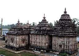
Temples
There are five temples under the management of Endowments Department[23].
| S.no | Temple | Mandal | Village |
| 1 | Sri Kodanda Rama Swamy Temple | SRIKAKULAM | BALAGA (RURAL) |
| 2 | Sri Maninageswara Swamy Temple | SRIKAKULAM | KALLEPALLE |
| 3 | Sri Kothamma Ammavari Temple | KOTABOMMILI | KOTABOMMILI |
| 4 | Sri Kota Durga Ammavari Temple | PALAKONDA | PALAKONDA |
| 5 | Sri Neelamani Durga Ammavari Temple | PATHAPATNAM | PATHAPATNAM |
See also
References
- 1 2 "District - Krishna". Andhra Pradesh Online Portal. Archived from the original on 23 September 2015. Retrieved 23 August 2014.
- ↑ "Srikakulam district profile". Andhra Pradesh State Portal. Archived from the original on 14 July 2014.
- ↑ "Iron Age habitation found in Srikakulam". The Hindu. 16 October 2011. Retrieved 14 June 2014.
- ↑ "Remnants of Jain monuments found". 21 August 2009. Retrieved 14 June 2014.
- ↑ Law, Gwillim (25 September 2011). "Districts of India". Statoids. Retrieved 11 October 2011.
- ↑ Srivastava, Dayawanti et al. (ed.) (2010). "States and Union Territories: Andhra Pradesh: Government". India 2010: A Reference Annual (54th ed.). New Delhi, India: Additional Director General, Publications Division, Ministry of Information and Broadcasting (India), Government of India. pp. 1111–1112. ISBN 978-81-230-1617-7.
- ↑ "Island Directory Tables: Islands by Land Area". United Nations Environment Program. 18 February 1998. Retrieved 11 October 2011.
Melville Island 5,765km2
- 1 2 3 4 5 6 "District Census 2011". Census2011.co.in. 2011. Retrieved 30 September 2011.
- ↑ US Directorate of Intelligence. "Country Comparison:Population". Retrieved 1 October 2011.
Kuwait 2,595,62
- 1 2 3 "District Level Household and Facility Survey (DLHS-3), 2007-08: India. Andhra Pradesh" (PDF). International Institute for Population Sciences and Ministry of Health and Family Welfare. 2010. Retrieved 3 October 2011.
- ↑ "District Census Handbook-Srikakulam" (PDF). Census of India. pp. 26–28, 54. Retrieved 18 January 2015.
- 1 2 "ULB Lists". Commissioner and Directorate of Municipal Administration. Retrieved 26 May 2017.
- ↑ "District-wise Assembly-Constituencies:". ceoandhra.nic.in.
- ↑ "Economy of Srikakulam District". Andhra Pradesh Economic Development Board. Retrieved 25 April 2017.
- ↑ von Fürer-Haimendorf, Christoph (1982). Tribes of India: The Struggle for Survival. University of California Press. pp. 77–78. ISBN 978-0-52004-315-2.
- ↑ "State Wise Registration Details of G.I Applications" (PDF). Geographical Indication Registry. p. 3. Archived from the original (PDF) on 1 February 2016. Retrieved 4 February 2016.
- ↑ ":: APRDC ::". Andhra Pradesh Road Development Corporation. Roads and Buildings Department. Retrieved 9 November 2016.
- ↑ "School Education Department" (PDF). School Education Department, Government of Andhra Pradesh. Archived from the original (PDF) on 27 December 2015. Retrieved 7 November 2016.
- ↑ "The Department of School Education - Official AP State Government Portal". www.ap.gov.in. Archived from the original on 7 November 2016. Retrieved 7 November 2016.
- ↑ "School Information Report". Commissionerate of School Education. Government of Andhra Pradesh. Archived from the original on 8 November 2016. Retrieved 8 November 2016.
- ↑ "Student Information Report". Commissionerate of School Education. Child info 2015-16, District School Education - Andhra Pradesh. Archived from the original on 22 May 2015. Retrieved 8 November 2016.
- ↑ "Welcome :: Dr.B.R.Ambedkar University, Srikakulam, AP. INDIA". brau.in. Archived from the original on 24 June 2011.
- ↑ "Trust Boards Abstract". AP Temples Portal, Government of Andhra Pradesh. Retrieved 24 July 2018.
External links
| Wikimedia Commons has media related to Srikakulam district. |
Places adjacent to Srikakulam district | ||||||||||
|---|---|---|---|---|---|---|---|---|---|---|
| ||||||||||