Anantapur district
| Anantapuramu district | |
|---|---|
| District of Andhra Pradesh | |
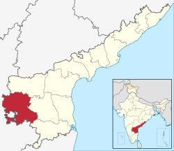 Location of Anantapuramu district in Andhra Pradesh | |
| Country | India |
| State | Andhra Pradesh |
| Headquarters | Anantapur |
| Tehsils | 63[1] |
| Government | |
| • District collector | Veera Pandyan IAS |
| • Lok Sabha constituencies | Anantapur, Hindupuram |
| • Assembly seats | 14 |
| Area | |
| • Total | 19,130 km2 (7,390 sq mi) |
| Population (2011) | |
| • Total | 4,083,315[2] |
| • Urban | 28.09% |
| Demographics | |
| • Literacy | 64.28% |
| • Sex ratio | 978 |
| Vehicle registration | AP-02 |
| Major highways | NH 44 |
| Coordinates | 14°42′N 77°36′E / 14.700°N 77.600°ECoordinates: 14°42′N 77°36′E / 14.700°N 77.600°E |
| Website | Official website |
Anantapur district (officially:Anantapuramu district[3]) is a district in the Rayalaseema region of Andhra Pradesh, India. The district headquarters is located at Anantapur city. As of 2011 Census, the district had a population of 4,083,315, of which 28.09% is urban and a literacy rate of 64.28%.[2] It is the largest district in terms of area in Andhra Pradesh and 7th largest district in India respectively.[4]
History
Gooty fort was a stronghold of the Marathas, but was taken from them by Hyder Ali. In 1789 it was ceded by his son Tipu Sultan to the Nizam of Hyderabad, and in 1800 the nizam ceded the surrounding districts to the British in payment for a subsidiary British force.[5] In 1882, Anantapuram district was formed by carving out from Bellary district.[6]
Geography

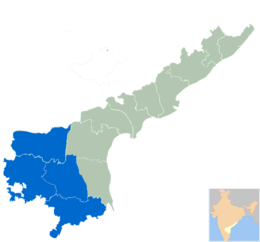
It is the largest district of Andhra Pradesh spanning an area of 19,130 square kilometres (7,390 sq mi),[7] comparatively equivalent to Japan's Shikoku Island.[8] It is bounded on the north by Kurnool District, on the east by Kadapa District, on the southeast by Chittoor District, and on the southwest and west by Karnataka state.[9] It is part of Rayalaseema region on the state. Its northern and central portions are a high plateau, generally undulating, with large granite rocks or low hill ranges rising occasionally above its surface. In the southern portion of the district the surface is more hilly, the plateau there rising to 2,000 ft (610 m). above the sea.[5] Six rivers flow within the district: Penna, Chithravathi, Vedavathi, Papagni, Swarnamukhi, and Thadakaleru. The district receives an average annual rainfall of 381 millimetres.
Anantapur city is 354 km from Hyderabad, 200 km from the neighbouring state capital of Bangalore. Anantapur connects Hyderabad and Bangalore through National Highway 7. There is an airport in the district located in Puttaparthi, known as Sri Sathya Sai Airport; however this airport currently has no scheduled service. Bangalore International Airport is nearest commercial airport to Anantapur District.
Demographics
As of 2011 census of India, Anantapur district has a population of 4,081,148 with 9,68,160 households, ranking it as the 7th most populous district in the state. It is the largest district in the state with an area of 19,130 km2 (7,390 sq mi).[10] Anantapur has a sex ratio of 977 females for every 1000 males, and a literacy rate of 63.57%.[11] Urban population in the district is 28.9% of total population.
Economy
The Gross District Domestic Product (GDDP) of the district is ₹35,838 crore (US$5.0 billion) and it contributes 6.8% to the Gross State Domestic Product (GSDP). For the FY 2013-14, the per capita income at current prices was ₹69,562 (US$970). The primary, secondary and tertiary sectors of the district contribute ₹9,944 crore (US$1.4 billion), ₹7,752 crore (US$1.1 billion) and ₹18,142 crore (US$2.5 billion) respectively to the GDDP.[12]
Agriculture and allied services Paddy and Groundnut are major Agricultural crops in the District. When it comes to Horticulture Banana and Papaya are heavily cultivated.
Industries Industries like Constructions, Manufactures and Electricity are major contributors for GVA.[12] Anantapur has a major potential for development of industry due to its strategic location between Bangalore – Chennai and Bangalore – Hyderabad routes and availability of vast tracts of land. In 2006 the Indian government named Anantapur one of the country's 250 most backward districts (out of a total of 640).[13] It is one of the thirteen districts in Andhra Pradesh currently receiving funds from the Backward Regions Grant Fund Programme (BRGF).[13]
Minerals Anantapur is a major producer of Dolomite and Iron Ore minerals.
Power plants Solar thermal power plant of 50 MW was commissioned at this village under Jawaharlal Nehru National Solar Mission which was named as Megha Solar Plant. It is one of the 7 solar thermal plants in the country.[14][15]
Silk sarees
Dharmavaram region in Anantapur is world-famous for the handmade pure silk sarees. Its a major hub for Silk trade with end to end silk related industries situated in the region supporting a major portion of population. Tadipatri region in Anantapur is an industrialised town famous for Granite and Cement production. Ultra Tech Cements a unit of Industrial major Larsen & Toubro has a major Cement production unit near the town.
Agriculture
The economy is principally agrarian with a developing industrial sector. Anantapur receives very less rainfall due to its location in the rain shadow area of Indian Peninsula. Prominent crops include groundnut, sunflower, rice, cotton, maize, chillies, sesame, and sugarcane. Silk trade, limestone quarrying, iron and diamond mining. Anantapur town is known as Groundnut City in reference to the neighbouring Bangalore being called as Garden City.
Religious tourism
Lepakshi, a village in Anantapur District famous for temple of Vijayanagara architectural style, Monolithic Lepakshi Nandi, and Hanging Pillar, Monolithic Naagalingam.
Puttaparthi region in Anantapur is home to the Ashram of Sathya Sai Baba, one of the most popular spiritual gurus of India. Puttaparthi has developed into a major tourist destination due to vast infrastructure created by the ashram he founded, known as Prasanthi Nilayam.
The Gooty Fort, also known as Ravadurg, is a ruined fort located on a hill in the Gooty town of anantapur Andhra Pradesh, India. The word Gooty (locally pronounced "Gutti") is derived from the town's original name, Gowthampuri. It is one of the centrally protected monuments of national importance.
Sri Malleswara Swamy Temple :-
Sri Malleswara Swamy Temple is Located at Kambadur ,Kambadur Mandal in Anantapur District,Andhra Pradesh State.This Temple is Dedicated to Malleswara Swamy.
Administrative divisions
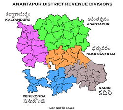
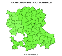
The District has 5 Revenue Divisions viz., Anantapur, Dharmavaram, Kadiri, Kalyandurg and Penukonda divisions. Kadiri and Kalyandurg divisions are formed in 2013.[16][17] These revenue divisions are further divided into 63 mandals.[10]
The mandals of the district are listed in the following table:
Transport
The total of core road network of the district is 9,188 km (5,709 mi). It includes, 353 km (219 mi) of National Highways and other roads of 8,835 km (5,490 mi).[18] It has a total Rail Network of which 340 km (210 mi) is Broad gauge and 249 km (155 mi) is Meter gauge. The major railways stations are Guntakal Junction, Dharmavaram Junction, Gooty Junction,Rayadurg Junction, Penukonda Junction, Sathya Sai Prasanthi Nilayam, Hindupur.
Education
The primary and secondary school education is imparted by government, aided and private schools, under the School Education Department of the state.[19][20] As per the school information report for the academic year 2015-16, there are a total of 5,024 schools. They include, 28 government, 3,435 mandal and zilla parishads, 4 residential, 1,154 private, 25 model, 62 Kasturba Gandhi Balika Vidyalaya (KGBV), 261 municipal and 55 other types of schools.[21] The total number of students enrolled in primary, upper primary and high schools of the district are 563,710.[22] The total number of students enrolled in primary, upper primary and high schools of the district are 563,266.[22]
Anantapur is an important education centre with many prominent educational, schools, colleges and universities situated in the district. Anantapur city has become a major hub with many education institutions situated in its vicinity. Some of the institutions include Sri Krishnadevaraya University, JNTU Ananthapur, Sri Sathya Sai University, Government Medical College, Government polytechnic anantapur , Srinivasa Ramanujan Institute of Technology, Government Polytechnic Hindupur.
Temples
The following sixty five temples under the management of Endowments Department[23].
| S.no | Temple | Mandal | Village |
| 1 | Sri Kona Ragnatha Swamy Temple | Tadpatri | Alur |
| 2 | Sri Kasivisweswara & Kodanda Rama Swamy Temples | Anantapur | Anantapur (Rural) |
| 3 | Sri Virupakeshwara & Obuleswara Swamy Temple | Anantapur | Anantapur (Rural) |
| 4 | Sri Peta Basaveswara Swamy Temple | Anantapur | Anantapur (Rural) |
| 5 | Sri Rama Swamy temple | Anantapur | Anantapur (Rural) |
| 6 | Sri Eswara & Anjaneya Swamy Temples | Pamidi | Anumpalle |
| 7 | "SRI MALAHOBULA NARASIMHA SWAMY TEMPLE, Y.KOTHAPALL (V)" | Atmakur | Atmakur |
| 8 | "SRI SUBRAMANYESWRA SWAMY TEMPLE,PAMPANUR(V)" | Atmakur | Atmakur |
| 9 | Sri Anjaneya Swamy Temple | Uravakonda | Budagavi |
| 10 | Sri Hanumantharaya Swamy temple | Beluguppa | Budigumma |
| 11 | Sri Venkateswara & Rama Swamy Temple | Beluguppa | Budigumma |
| 12 | Sri Gonimadugula Venkataramana Swamy temple | Singanamala | Chakrayapeta |
| 13 | Sri Anjaneya & Venkateswara Swamy Temple | Bukkarayasamudram | Chennampalle |
| 14 | Sri Katakoteswara Swamy temple | Tadimarri | Chillavaripalle |
| 15 | Sri Durgamma Devatha Temple | Dharmavaram | Dharmavaram |
| 16 | Sri Lakshmi Chennakesava Swamy Temple | Dharmavaram | Dharmavaram |
| 17 | Sri Panduranga Swamy Temple | Dharmavaram | Dharmavaram |
| 18 | Sri Virupakeshwara & Anjaneya Swamy Temples | Guntakal | Donimukkala |
| 19 | Sri Eswara Swamy temple | Narpala | Duggumarri |
| 20 | Sri Malleswara Swamy temple | Kalyandurg | East Kodipalle |
| 21 | Sri Venkateswara Swamy Temple | Garladinne | Garladinne |
| 22 | Sri Rama & Narasimha Swamy Temple | Gooty | Gooty (Rural) |
| 23 | Sri Yellamma Devatha Temple | Gooty | Gooty (Rural) |
| 24 | Sri Anjaneya Swamy Temple | Narpala | Gugudu |
| 25 | Sri Kullaya Swamy Temple | Narpala | Gugudu |
| 26 | Sri Kodanda Rama Swamy Temple | Guntakal | Guntakal |
| 27 | Sri Siddeswara Swamy Temple | Amarapuram | Hemavathi |
| 28 | Sri Anantha Padmanba Swamy temple | Hindupur | Hindupur |
| 29 | Sri Guddam Ranganatha Swamy Temple | Hindupur | Hindupur |
| 30 | Sri Peta Venkataramana Swamy Temple | Hindupur | Hindupur |
| 31 | Sri Suguru Anjaneya Swamy Temple | Hindupur | Hindupur |
| 32 | Sri Venugopala Swamy Temple | Hindupur | Hindupur |
| 33 | Sri Dona Thimmaraya Swamy temple | Kalyandurg | Hulikal |
| 34 | Sri Khadri Lakshmi Narasimha Swamy Temple | Kadiri | Kadiri (Rural) |
| 35 | "Sri Akkamma Devatha Temple, Ontimidde(V)" | Kalyandurg | Kalyandurg (Rural) |
| 36 | Sri Anjaneya Swamy Temple | Pamidi | Kandlapalle |
| 37 | Sri Nettikanti Anjaneya Swamy Temple | Guntakal | Kasapuram |
| 38 | "Sri Chennakesava, Anjaneya, Malleswara & Veerabhadra Swamy Temples" | Pamidi | Katrimala |
| 39 | Sri Gunti Subramanyeswara Swamy Temple | Garladinne | Kotanka |
| 40 | "Sri Lakshmi Narasimha and Anjaneya swamy temples., Baktharahalli & Jilledukunta (V)" | Madakasira | Madakasira |
| 41 | Sri Kalleswara & Basaveswara Swamy Temple | Kanekal | Malyam |
| 42 | "Sri Anjaneya, Chennakesava & Kasiviweswara Swamy temples" | Hindupur | Manesamudram |
| 43 | Sri Anjaneya Swamy Temple | D.Hirchal | Muradi |
| 44 | Sri Anjaneya Swamy temple | Rayadurg | Nagireddipalle |
| 45 | Sri Anjaneya Swamy Temple | Bommanahal | Nemakallu |
| 46 | Sri Venugopala & Anjaneya Swamy temple | Singanamala | Nidhanawada |
| 47 | Sri Bhogeswara &Chennakesava Swamy Temples | Pamidi | Pamidi |
| 48 | Sri Lakshmi Narayana & Anantha Gajagaruda Swamy Temples | Pamidi | Pamidi |
| 49 | Sri Siddeswara & Anjaneya Swamy Temples | Uravakonda | Pedda Musturu |
| 50 | "SRI ASWARTHA NARAYANA & BHEEMALINGESWARA SWAMY TEMPLE, A. PAPPURU" | Peddapappur | Peddapappur |
| 51 | Sri Jambukeswara Swamy Temple | Rayadurg | Rayadurg |
| 52 | Sri Prasana Venkataramana Swamy Temple | Rayadurg | Rayadurg |
| 53 | Sri Veerabhadra and Basaveswara Swamy Temple | Rayadurg | Rayadurg |
| 54 | Sri Madhava Swamy temple | Atmakur | Sanapa |
| 55 | Sri Rameswara Swamy temple | Atmakur | Sanapa |
| 56 | Sri Madugiri Narasimha Swamy temple | Chilamathur | Somaghatta |
| 57 | Sri Anjaneya Swamy temple | Hindupur | Sreekanthapuram (Rural) |
| 58 | Sri Bugga Ramalingeswara Swamy Temple | Tadpatri | Tadpatri (R) |
| 59 | Sri Chinthala Venkataramana Swamy Temple | Tadpatri | Tadpatri (R) |
| 60 | Sri Chennakesava & Pothularaju Swamy temple | Atmakur | Talupuru |
| 61 | Sri Anjaneya Swamy temple | Beluguppa | Thagguparthy |
| 62 | Sri Bolikonda Ranganatha Swamy Temple | Gooty | Thondapadu |
| 63 | Sri Ranganatha Swamy Temple | Brahmasamudram | Vepalaparthy |
| 64 | Sri Lakshmi Chennakesava Swamy temple | Yadiki | Yadiki |
| 65 | "Sri Kodigundla Lingamaiah, Eswara & Venkataramana Swamy Temples" | Guntakal | Yerrathimmaraju Cheruvu |
References
- ↑ "District – Guntur". Andhra Pradesh Online Portal. Archived from the original on 28 April 2015. Retrieved 23 August 2014.
- 1 2 "Anantapur district profile". Andhra Pradesh State Portal. Archived from the original on 15 July 2014.
- ↑ Reporter, Staff. "Anantapur district to be renamed Anantapuram". The Hindu. Retrieved 5 June 2017.
- ↑ "Top 10 Largest Districts of India by Total Area". census2011.co.in.
- 1 2

- ↑ Rayudu, C. S. (1 January 1991). Rural Credit in India: A Study of Andhra Pradesh. Mittal Publications. p. 2. ISBN 9788170992486.
- ↑ Srivastava, Dayawanti; et al., eds. (2010). "States and Union Territories: Andhra Pradesh: Government". India 2010: A Reference Annual (54th ed.). New Delhi, India: Additional Director General, Publications Division, Ministry of Information and Broadcasting (India), Government of India. pp. 1111–1112. ISBN 978-81-230-1617-7.
- ↑ "Island Directory Tables: Islands by Land Area". United Nations Environment Program. 18 February 1998. Retrieved 11 October 2011.
Shikoku 18,545km2
- ↑ "Historical Background". Archived from the original on 15 May 2013.
- 1 2 "District Census Handbook – Anantapur" (PDF). Census of India. p. 14. Retrieved 18 January 2015.
- ↑ "Census 2011". Official website of Anantapuram district. Retrieved 19 March 2016.
- 1 2 "Economy of Anantapur District". Andhra Pradesh Economic Development Board. Retrieved 25 April 2017.
- 1 2 Ministry of Panchayati Raj (8 September 2009). "A Note on the Backward Regions Grant Fund Programme" (PDF). National Institute of Rural Development. Archived from the original (PDF) on 5 April 2012. Retrieved 27 September 2011.
- ↑ "Megha Solar Plant". National Renewable Energy Laboratory. Retrieved 29 April 2015.
- ↑ "Anantapur Gets Solar Power Plant". The New Indian Express. Hyderabad. 14 November 2014. Retrieved 29 April 2015.
- ↑ "Historical Background". Anantapur District Official website. National Informatics Centre. Retrieved 3 November 2014.
- ↑ "Anantapur gets two more revenue divisions". The Hindu. Anantapur. 27 June 2013. Retrieved 3 November 2014.
- ↑ "APEDB Anantapur". Andhra Pradesh Economic Development Board. Retrieved 25 April 201. Check date values in:
|accessdate=(help) - ↑ "School Education Department" (PDF). School Education Department, Government of Andhra Pradesh. Archived from the original (PDF) on 19 March 2016. Retrieved 7 November 2016.
- ↑ "The Department of School Education - Official AP State Government Portal". www.ap.gov.in. Archived from the original on 7 November 2016. Retrieved 7 November 2016.
- ↑ "School Information Report". Commissionerate of School Education. Government of Andhra Pradesh. Archived from the original on 8 November 2016. Retrieved 8 November 2016.
- 1 2 "Student Information Report". Commissionerate of School Education. Child info 2015-16, District School Education - Andhra Pradesh. Retrieved 8 November 2016.
- ↑ "Trust Boards Abstract". AP Temples Portal, Government of Andhra Pradesh. Retrieved 24 July 2018.
External links
| Wikimedia Commons has media related to Anantapur district. |
Places adjacent to Anantapur district | |
|---|---|