Palakollu
| Palakollu | |
|---|---|
| Town | |
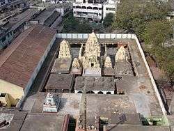 Sri Kshira Rama Ligeswara Swamy Temple. | |
 Palakollu  Palakollu | |
| Coordinates: 16°32′00″N 81°44′00″E / 16.5333°N 81.7333°ECoordinates: 16°32′00″N 81°44′00″E / 16.5333°N 81.7333°E | |
| Country |
|
| State | Andhra Pradesh |
| Region | Coastal Andhra |
| District | West Godavari |
| Government | |
| • Type | Nagar Palika |
| • Body | Palakollu Municipality |
| • MLA (Palakollu Assembly) | Nimmala Rama Naidu (2014 - present) |
| • MP (Narasapur Lok Sabha) | Gokaraju Ganga Raju (2014 - present) |
| Area[1] | |
| • Town | 19.49 km2 (7.53 sq mi) |
| Elevation | 1.5 m (4.9 ft) |
| Population (2011) | |
| • Town | 61,284 [2] |
| • Metro[3] | 81,199 |
| Languages | |
| • Official | Telugu |
| Time zone | UTC+5:30 (IST) |
| PIN | 53426× |
| Telephone code | 08814 |
| Vehicle registration | AP37 |
| International Airport | Vijayawada Airport |
| Police | Andhra Pradesh Police |
| Railway station | Palakollu railway station |
| Seaport | Kakinada Port |
| Sex ratio | 1031/1000 ♀/♂ |
| HDI |
|
| HDI Category | medium |
| Literacy | 83.41% |
| Website |
palakol |
Palakollu /ˈpɑːlɑːkɒlluː/ () is the administrative headquarters of Palakollu Mandal in Narasapuram revenue division in West Godavari district of the Indian state of Andhra Pradesh. Palakollu is situated in Coastal Andhra region of the state.[4] Occupying 19.49 square kilometres (7.53 sq mi) [5] As of 2011 census, it has a population of about 61.2 kilo and a Metro population of about 81.1 kilo, making it the fourth most populous city in West Godavari District in Andhra pradesh.[6] Palakollu City was selected for the year 2015-16 Housing for All Under Pradhan Mantri Awas Yojana for house less poor in the urban areas. At an average altitude of 1.5 metres (4.9 ft), Palakollu city is situated on National Highway 165 (India) and National Highway 216 (India) It is bounded by Krishna district on the west, East Godavari district on the east, Bay of Bengal on the south and the state of Telangana on the north.[7] which is home to Ksheerarama, one of the five great Pancharama Kshetras.
History
Palakol or Palakollu was originally known as Kshiraramam or Kshirapuram or Palakolanu or Upamanyapuram. [8]
In 1613, the Dutch built their first Indian factory at Palakollu, which was temporarily abandoned in 1730. Part of Dutch Coromandel, it was a trading post for textiles, lamp oil, wood, roof tiles, and bricks.
Under the 1783 Treaty of Paris, the town was ceded to the British, but the Dutch continued to rent it from them until 1804. In 1818 it was formerly restored to the Dutch only to be ceded again to the British in 1824.[9]
Palakollu is also known as Trilinga Desam, the region bounded by three lingas (Srisailam, Draksharamam and Kaleswaram)
The most famous Ksheerarama is one, of the five, Pancharama Kshetras and is located in Palakollu, state of Andhra Pradesh, India. Lord Shiva is known locally as Ksheera Ramalingeswara Swamy. The Sivalinga was established by Lord Vishnu.
The famous Sri Lakshmi Ganapathi Navagraha Subrahmanya Aalayam, temple located at Brodipeta 2nd Lane in Palakollu. The presiding deity is Lord Ganapathi in the divine form of Lakshmi Ganapathi, along with the Navagrahalu & Subrahmanya Swamy deities. [10]
Geography
Palakollu Is Located At 16°31′00″N 81°43′48″E / 16.5167°N 81.7300°E.[11] Situated in the southern part of Andhra Pradesh in southeastern India.The City occupies an area of 19.49 square kilometres (7.53 sq mi) under the administration of Palakollu Municipality (PMC). There are One major Dhavaleswaram - Narsapuram Canal that supply water to the city: New Water Lake And old water lake A part from the Godavari River. Small canal's is used only for agricultural and industrial purposes. Palakollu Town is a flat country with a slight eastern slope along the Canal's of the City flow. The Canal's in the palakulu city generally flow from West to East. with an average elevation of 1.5 metres (4.9 ft). The City is bounded by Penugonda Village on the north, Narasapuram on the south. The Godavari River separates East Godavari district on east and Bhimavaram on the west. There is paddy and sugarcane cultivation in the area.
Climate
Palakollu has a tropical climate. When compared with winter, the summers have much more rainfall. The climate here is classified as Aw by the Köppen-Geiger system. In Palakollu, the average annual temperature is 27.9 °C. In a year, the average rainfall is 1208 mm.The driest month is January, with 1 mm of rainfall. In October, the precipitation reaches its peak, with an average of 286 mm.The warmest month of the year is May, with an average temperature of 32.4 °C. At 23.4 °C on average, January is the coldest month of the year. The difference in precipitation between the driest month and the wettest month is 285 mm. The variation in annual temperature is around 9.0 °C. The weather is hot and humid, with a tropical climate and, thereby, no distinct seasons. The coolest months are December and January There is heavy monsoon rain at the end of summer, with depressions in the Bay of Bengal.
| Month | Jan | Feb | Mar | Apr | May | Jun | Jul | Aug | Sep | Oct | Nov | Dec | Year |
|---|---|---|---|---|---|---|---|---|---|---|---|---|---|
| Average high °C (°F) | 27.7 (81.9) |
30 (86) |
32.8 (91) |
35 (95) |
37 (99) |
36.3 (97.3) |
32.4 (90.3) |
32.2 (90) |
32 (90) |
31 (88) |
28.8 (83.8) |
27.6 (81.7) |
31.9 (89.5) |
| Daily mean °C (°F) | 23.4 (74.1) |
25.4 (77.7) |
27.8 (82) |
30.5 (86.9) |
32.4 (90.3) |
31.8 (89.2) |
29 (84) |
28.9 (84) |
28.8 (83.8) |
27.8 (82) |
25.4 (77.7) |
23.5 (74.3) |
27.9 (82.2) |
| Average low °C (°F) | 19.2 (66.6) |
20.9 (69.6) |
22.8 (73) |
26 (79) |
27.8 (82) |
27.3 (81.1) |
25.6 (78.1) |
25.6 (78.1) |
25.6 (78.1) |
24.6 (76.3) |
21.1 (70) |
19.4 (66.9) |
23.8 (74.9) |
| Average precipitation mm (inches) | 1 (0.04) |
6 (0.24) |
4 (0.16) |
7 (0.28) |
41 (1.61) |
145 (5.71) |
266 (10.47) |
190 (7.48) |
191 (7.52) |
286 (11.26) |
52 (2.05) |
19 (0.75) |
1,208 (47.56) |
| Average precipitation days | 1.2 | 0.2 | 0.2 | 0.4 | 1.6 | 3.0 | 6.1 | 6.4 | 5.4 | 8.7 | 9.1 | 3.7 | 46.0 |
| Source: India Meteorological Department (climate data)[12] | |||||||||||||
Culture
The town is known in the state for its cultural history whose residents are more often referred as 'Palakollu' There are many religions, languages, traditions and festivals. Shiva Puja and a special Maha Shivaratri Karthika Masam in Karthikai Deepam are important events of Hindu festival of Makar Sankranti in the town, mainly due to the existence of self manifested Ksheerarama Temple. Palakollu town Mosque is a Muslim shrine housing the holy relic of the Prophet Mohammed. The ST. John Luther Church, Sambhunipeta Luthern church, Church Of Christ, St. Andrews Lutheran Church, is an important shrine for Christians and illuminates during Christmas eve.The clothing of the locals include traditional men wearing dhoti and women wearing saree and salwar kameez. Western clothing is also predominant. And Also Some Important Famous food Of andhra pradesh.
Film Industry People
The town notable for many artists like Chiranjeevi, Allu Ramalingiah, Allu Aravind, Allu Arjun, Kodi Ramakrishna, Dasari Narayana Rao, Chalam, Mandolin Srinivas, RaviRaja Pinisetty, Chintapalli Ramana, Nookala Chinna Satyanarayana, Ghazal Srinivas (recipient of Guinness World Record for most languages sung), Beri Thimappa (Founder of Madras), Veera Pothana (Nandi awardee, cine & drama writer), R. NaniKrishna (Film Director and Producer), Chanti Addala (art director & producer), Relangi Narasimha Rao (director), Bunny vasu (producer), Maruthi (Director), Ananth Sriram (Liricyst).
Allu Rama Lingaiah (1 October 1922 – 31 July 2004), commonly known as Allu, was an Indian Telugu language comedic actor from Palakollu, who appeared in over one thousand Tollywood films.
Anantha Sriram Chegondi (born 8 April 1984) is an Indian lyricist, mainly writing lyrics for songs in Telugu language films. He is a nephew of the politician and cine producer Chegondi Venkata Harirama Jogaiah and hails from Palakollu area of West Godavari district of Andhra Pradesh. He studied in Bapatla Engineering College. He discontinued studies when he was in 3rd year of graduation. Anantha Sriram is one of the most sought after lyricists in the Telugu Film Industry. Sriram is married to Swathy in Palakollu on November 17, 2010.
Dasari Narayana Rao (born 4 May 1936, Palakol, West Godavari, Andhra Pradesh, India) is an Indian film actor, director and producer from Telugu cinema and a Politician.Dasari Narayana Rao has directed about 140 films, produced 3 films and worked in more than 2 films as a dialogue writer and as a lyricist. Besides graduating with a BA degree, he used to take part in scores of drama competitions. He was soon recognized as a potential stage artiste, screenwriter and director. During his career he has also acted in Telugu, Tamil, and Kannada languages. His films were mostly based on Anti Dowry issue and women centric issues and always carried a messgae. He has directed Blockbusters like Bobbili Puli and Sardar Paparayudu with NTR. His other memorable blockbusters include Meghasandesam, Mamagaru, Chillara Kottu Chittemma and Premabhishekam. He has introduced actors and directors like Mohan Babu, R. Narayana Murthy, Raviraja Pinisetty and Mutyala Subbaiah
Governance
Civic administration
Palakollu Municipality was established in the year 1928. It was A grade Municipality.There are 32 election wards represented by a councilor. Palakollu City urban agglomeration is spread over an area of 19.49 km2 (7.53 sq mi). Its constituents include the municipality of Palakollu, the out growths of Poolapalli, Ullamparru, Palakollu (Rural)
Palakollu (Assembly constituency) is a legislative assembly constituency in Andhra Pradesh. Sri Chodisetty Surya Rao was longest serving municipal chairman from 1956 to 1986 and many colleges ASNM, Dasari Womens degree college, Coco Junior govt college, 34 acres of drinking water tank developed with 20 year vision, govt hospital, lorry stand, etc are all developed under his regime. As a gratitude people of Palakol erected a bronze statue in center of City.[13]
Politics
Palakollu Assembly constituency is one of the constituencies for Andhra Pradesh Legislative Assembly. Nimmala Rama Naidu is the present MLA of the constituency from Telugu Desam Party.[14] The constituency falls under Narasapuram (Lok Sabha constituency) which was won by Gokaraju Ganga Raju of Bharatiya Janata Party.[15][16] And Also Another Major Parts In Palakollu City Janasena Party And Ysr Congress Part.
Demographics
| Palakollu population | |||
|---|---|---|---|
| Census | Pop. | %± | |
| 1901 | 10,848 | — | |
| 1911 | 12,953 | 19.4% | |
| 1921 | 14,535 | 12.2% | |
| 1931 | 16,906 | 16.3% | |
| 1941 | 19,869 | 17.5% | |
| 1951 | 23,037 | 15.9% | |
| 1961 | 28,481 | 23.6% | |
| 1971 | 36,196 | 27.1% | |
| 1981 | 46,146 | 27.5% | |
| 1991 | 56,969 | 23.5% | |
| 2001 | 76,308 | 33.9% | |
| 2011 | 81,199 | 6.4% | |
| Sources:[17] [18] | |||
As of 2011 census of India, the City had a population of 81,199. The total population constitutes 40,103 males and 41,096 females—a sex ratio of 1024 females per 1000 males. 7,318 children are in the age group of 0–6 years, of which 3,743 are boys and 3,575 are girls—a ratio of 955 girls per 1000 boys. The average literacy rate stands at 76.95% significantly higher than the state average of 73.00%.[19] [20][21][22]
Language and religion
Referred to as "Palakolian", the residents of Palakollu are predominantly Telugu with minority Gujarati (including Memon). Telugu is official Language. Hindus are in the majority. Muslims And Christians form a very Less minority Of The People In Palakollu. According to the 2011 census, the religious make-up of Palakollu City was: Hindus (95.64%), Muslims (2.11%), Christians (1.97%), Jains (40 People), Sikhs (10 People) and Buddhists (3 People); 143 People did not state any religion.[23]
Economy
Agriculture-based businesses like food processing, rice mills etc., are the chief sources of the town's revenue. It serves as a distribution centre as well as commercial centre to its hinterland. The town is the regional centre for higher education and is known for its specialized health services Palakollu Coconet Market It's Big Coconut Market In West Godavari District Palakollu Coconut Export To Over All India.[25]
Transport
The city was once famed for its traffic problems with the railway gates at Bhimavaram Road (P.P Road) area. When the National Highway passed through the city, the traffic hurried to pass over the railway gate in the city and outskirts, which makes traffic worse.
To avoid the traffic congestion, the government of India constructed a mini bypass road connecting Narsapur Road and Poolapalli on both ends of the city. Even then, the traffic problem were not resolved. The main bypass road (which was constructed under R&B which was completed in the late 2014s) had only 10,000 vehicles pass through the bypass road; now it has almost doubled.
Traffic in the city of narrow lanes was growing by the day. Even though officials planning to construct an underbridge at Bhimavaram Road (P.P Road) railway overbridge it is already approved from South Central railway at Palakollu City But still Pending in the project. and in the city all National Roads and R&B Roads still single lines only thay try to Since 1950 extend Roads making the one way but This is also Still Pending. 2018 year the traffic has doubled, without giving any relief to citizens. There are 25 traffic centres identified in the city.
Roadways

Sri Potti Sriramulu bus station Located in palakollu City APSRTC operates buses from Palakollu to major cities like Hyderabad, Vizag, Vijayawada, Tirupati etc. Ten express trains service the City, which is on the Narsapur – Vijayawada railway route.[26] A bridge was built on Vasista Godavari near Chinchinada 8 km away from Palakollu connecting East Godavari & West Godavari Districts of Andhra Pradesh, which makes it a part of National Highway 214. Palakollu railway station is classified as a B–category station in the Vijayawada railway division of South Central Railway zone.[27] The town has a total road length of 78.80 km (48.96 mi).[28]
Railways
Palakollu railway station is classified as an B category station With Three Platforms In Vijayawada railway division.[29] Palakollu Railway Station One Of The Main Station It is located on the Bhimavaram–Narasapuram branch line of South Central Railway zone.[30]
Waterways
National Waterway 4 was declared on 24 November 2008, which connects the Indian states of Telangana, Andhra Pradesh, Tamil Nadu, and the union territory of Puducherry. It passes through Kakinada, Eluru, Commanur, Buckingham Canal and also part of Krishna and Godavari rivers rivers.[31] It is being developed by Inland Waterways Authority of India, and is scheduled for completion in 2013.[32]
Airways
Palakollu City Nearest Airport Rajahmundry Airport It Is Around 84Km Distance Of The City.[33] Jet Airways, Spicejet, IndiGo and TruJet are major airliners. The airport has direct services to Hyderabad, Chennai and Bangalore. A new terminal building was inaugurated on 16 May 2012. Runway is being expanded from the 1,749 m to 3,000 m to facilitate the landing and takeoff of bigger aircraft.[34] The state government is very keen in developing the airport as a national airport and alternative for Visakhapatnam airport during bad climatic conditions.[35]
Education
Palakollu plays a major role in education for urban and rural students from nearby villages.[36] It has an average literacy rate of 83.90% with, according to the 2011 census, a total number of 63,097 who are literate. This includes, 32,397 men (88.13%) and 30,700 women(79.82%). Primary and secondary school education is provided by government, aided, and private schools, under the School Education Department of Andhra Pradesh.[37] According to the school information report for the academic year 2016–17, the urban area has around 160 schools. These include government, residential, private, municipal, and other types of schools. There are more than 100 private schools and 49 municipal schools.[38] There are more than 30,000 students in these schools.[39]
Instruction is in English, Urdu, and Telugu.
There are numerous higher educational institutions in and around Palakollu City.[40] Some of the renowned institutions are Jogaiah Institute of Technology and Sciences,[41] D.N.R Educational Institutions,[42] Jogaiah Institute of agricultural engineering, A.S.N.M degree and P.G college, B.R.R & G.K.R Chambers Degree & PG College, Jogaiah institute of Technology and Sciences, College of Pharmacy.[43]
See also
References
- ↑ "Municipalities, Municipal Corporations & UDAs" (PDF). Directorate of Town and Country Planning. Government of Andhra Pradesh. Archived from the original (PDF) on 28 January 2016. Retrieved 29 January 2016.
- ↑ "Palakollu 2011 Census india". Census of india gov. 2011 census of india & Municipal Administration and Urban Development Department, Government of Andhra Pradesh. Retrieved 10 June 2018.
- ↑ "Andhra Pradesh (India): State, Major Agglomerations & Cities – Population Statistics in Maps and Charts". citypopulation.de.
- ↑ "West Godavari District Mandals" (PDF). Census of India. p. 457. Retrieved 19 January 2015.
- ↑ "District Census Handbook – West Godavari" (PDF). Census of India. p. 22,23–54. Retrieved 22 September 2015.
- ↑ "Palakollu 2011 Census india". Census of india gov. 2011 census of india & Municipal Administration and Urban Development Department, Government of Andhra Pradesh. Retrieved 19 August 2014.
- ↑ "West Godavari". Official portal of Andhra Pradesh Government. Retrieved 13 March 2016.
- ↑ Pañchārāmas in medieval Āndhradēśa (Google eBook)
- ↑ Bowrey, Thomas (1895). Temple, Richard Carnac, ed. A Geographical Account of Countries Round the Bay of Bengal, 1669 to 1679. p. 105.
- ↑ Readings in Indian History. Selected And Edited by Sir William Wilson Hunter 1899 (Google eBook)
- ↑ "Palakollu Maps And Weather".
- ↑ climate data Information For Palakollu. "Palakollu". climate data. Retrieved April 17, 2018.
- ↑ {{|url=http://palakol.cdma.ap.gov.in/en/about-palacole-municipality |title= Palakollu Municipality About}}
- ↑ "MLA". AP State Portal. Retrieved 18 September 2015.
- ↑ "MP (Lok Sabha)". Government of AP. Retrieved 4 May 2015.
- ↑ "Delimitation of Parliamentary and Assembly Constituencies Order, 2008" (PDF). Election Commission of India. p. 20,30. Retrieved 11 October 2014.
- ↑ "Palakollu 2011 Census india". Census of india gov. 2011 census of india & Municipal Administration and Urban Development Department, Government of Andhra Pradesh. Retrieved 19 August 2014.
- ↑ name="census2011">"Palakollu Population". Government of India, Ministry of Home Affairs. Archived from the original on 13 September 2015. Retrieved 17 April 2018. On this page, select "Andhra Pradesh" from the download menu In Town Amenities. Data for Palacole (M + OG)" is at row 234 of the downloaded excel file.
- ↑ "West Godavari febsus Handbook Census india" (PDF). Census of India District Census Handbook. 2011 census of india & Municipal Administration and Urban Development Department, Government of Andhra Pradesh. p. 54,55. Retrieved 10 June 2018.
- ↑ "Andhra Pradesh (India): Districts, Cities, Towns and Outgrowth Wards – Population Statistics in Maps and Charts". citypopulation.de.
- ↑ "Literacy of AP (Census 2011)" (PDF). AP govt. portal. p. 43. Archived from the original (PDF) on 14 July 2014. Retrieved 11 June 2014.
- ↑ "Palakollu 2011 Census india". Census of india gov. 2011 census of india & Municipal Administration and Urban Development Department, Government of Andhra Pradesh. Retrieved 19 August 2014.
- ↑ "C-1 Population By Religious Community". Government of India, Ministry of Home Affairs. Archived from the original on 13 September 2015. Retrieved 11 May 2016. On this page, select "Andhra Pradesh" from the download menu. Data for Palacole (M + OG)" is at row 2393 of the downloaded excel file.
- ↑ name="census2011">"C-1 Population By Religious Community". Government of India, Ministry of Home Affairs. Archived from the original on 13 September 2015. Retrieved 11 May 2016. On this page, select "Andhra Pradesh" from the download menu. Data for Palacole (M + OG)" is at row 2393 of the downloaded excel file.
- ↑ "Coconut Top 50 Distributors In palakollu".
- ↑ http://www.indianrailways.gov.in/maps/st-cent-rly.htm
- ↑ "Divisional info" (PDF). Indian Railways. Retrieved 18 July 2015.
- ↑ "Details of Roads in each ULB of Andhra Pradesh". Commissioner and Directorate of Municipal Administration. Municipal Administration and Urban Development Department - Government of Andhra Pradesh. Retrieved 28 March 2017.
- ↑ "Statement showing Category-wise No.of stations" (PDF). Indian Railways. p. 2. Retrieved 12 May 2017.
- ↑ "Railway station to have two more platforms".
- ↑ Ministry of Shipping (Government of India). "National waterways Declaration". Archived from the original on 10 April 2009. Retrieved 5 August 2010.
- ↑ Press Information Bureau, Government of India (2 August 2010). "Development Authority for Inland Waterways in India". Retrieved 5 August 2010.
- ↑ "Rajahmundry airport tops in occupancy rates".
- ↑ "Gearing up for Big Planes by 2018".
- ↑ "Rajahmundry airport terminal operational". The Hindu Business Line. 17 May 2012. Retrieved 24 June 2014.
- ↑ "Palakollu Municipal Corporation Schools". Palakol.cdma.ap.gov.in. Retrieved 1 April 2017.
- ↑ "School Education Department" (PDF). Rashtriya Madhyamik Shiksha Abhiyan (RMSA). School Education Department, Government of Andhra Pradesh. Archived from the original (PDF) on 21 October 2016. Retrieved 1 April 2017.
- ↑ "R1.1 SCHOOL INFORMATION".
- ↑ "R3.1 STUDENT INFORMATION".
- ↑ "Palakollu City Schools, Colleges, Engineering Colleges, Degree Colleges List".
- ↑ "Jits Engineering College".
- ↑ "(Autonomous) Affiliated to Andhra University, Reaccredited at the "A" Level by NAAC". DNR College Palakollu. Retrieved 2015-08-29.
- ↑ "Jogaiah Institute of technology and sciences collage of pharmacy". Jogaiah Medical Collage. Retrieved 1 April 2017.
External links
| Wikivoyage has a travel guide for Palakollu. |
| Wikimedia Commons has media related to Palakollu. |