Kalpeshwar
| Kalpeshwar Temple | |
|---|---|
 | |
 Location in Uttarakhand | |
| Geography | |
| Coordinates | 30°34′37.35″N 79°25′22.49″E / 30.5770417°N 79.4229139°ECoordinates: 30°34′37.35″N 79°25′22.49″E / 30.5770417°N 79.4229139°E |
| Country | India |
| State | Uttarakhand |
| Culture | |
| Sanctum | Shiva |
| Architecture | |
| Architecture | North Indian architecture |
| History | |
| Date built | Unknown |
| Creator | Pandavas |
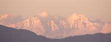
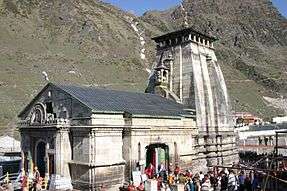
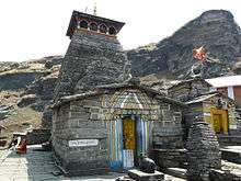
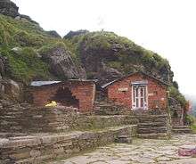
Kalpeshwar (Sanskrit: कल्पेश्वर) is a Hindu temple dedicated to Lord Shiva located at an elevation of 2,200 m (7,217.8 ft) in the picturesque Urgam valley in the Garhwal region of Uttarakhand state in India. The temple’s ancient legend linked to the Pandavas, heroes of epic Mahabharata eminence is the fifth temple of the Panch Kedars (five temples) of Shiva’s five anatomical divine forms; the other four temples in the order of their worship are Kedarnath, Rudranath, Tungnath and Madhyamaheshwar temples; all in the Kedar Khand region of the Garhwal Himalayas.[1][2][3] Kalpeshwar is the only Panch Kedar temple accessible throughout the year. At this small stone temple, approached through a cave passage, the matted tress (jata) of Lord Shiva is worshipped. Hence, Lord Shiva is also called as Jatadhar or Jateshwar. Earlier it was approachable only by 12 km (7.5 mi) trek from the nearest road head of Helang on the Rishikesh-Badrinath road but now the road goes up to Devgram village from where the trek now is just 300 metres. This road is good for bikes or cars with good ground clearance as it is half kuccha road which may get damaged during monsoons. Small cars can be taken except in monsoons.[1]
Legend
The epic legend narrated on the creation of the Panch Kedar temples is that Pandavas of Mahabharata epic history, while chasing Lord Shiva to seek his pardon for the fratricidal sins committed by them during the Kurukshetra war, realized that Shiva, in order to distance himself from the Pandavas, took the incognito form of a bull. But when this form of Shiva was discerned by Bhima, the second of the Pandava brothers, tried to hold on to the bull's tail and hind legs. But the bull vanished underground at Guptakashi. Subsequently, it reappeared in five different forms: His hump appeared at Kedarnath, his bahu (arm) was spotted at Tungnath, his head surfaced at Rudranath, the stomach and navel were traced at Madhyamaheswar and his jata (tress) was divined at Kalpeshwar.[4] Another legend states that this place was much preferred by sages of folklore for meditation. Particular mention is made of sage Arghya who through his austere penance created Urvashi, the famous apsara (nymph) at this place. Durvasa, an ancient sage, son of Atri and Anasuya, considered an incarnation of Shiva, known for his short temper did penance and meditated under the Kalpavriksha, the wish fulfilling divine tree in the precincts of the temple.[3] Further, it is said that Durvasa had given Kunti, mother of Pandavas, a boon that "she could invoke any of the forces of nature and they would appear before her and grant whatever she desired". Once, when Pandavas, were in exile here, in order to test them Durvasa visited them along with his disciples and desired to be dined by them. Unfortunately, there was no food available within the house to feed the surprise guests. Draupadi, wife of Pandavas, sought Lord Krishna's help. Krishna materialised on the scene and solved the problem.[5]
- Worship
The temple priests at this temple also are the Dasnamis and Gossains, disciples of Adi Shankara. At Tungnath also the priests are Khasiya Brahmins. These priests hail from South India; the Namboodiri brahminfrom Kerala sect who worship at Badrinath. at Kedarnath , the Jangamas are lingayats from Mysore. in all these temples the pooja is designed by adi sankara. these priests also are supposed to be appointed by Adi Shankara. The priests at the Rudranath temple are Dasnamis and Gosains.[6]
Geography
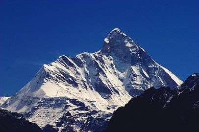
The Kalpeshwar temple is located in the Urgam valley of the Himalayan mountain range near Urgam village (2 km (1.2 mi) short of the temple). On the bridle path from Helang to Kalpeshwar, the confluence of the Alaknanda and Kalpganga rivers is seen. Kalpganga river flows through the Urgam valley.[7][8] The Urgam valley is a dense forest area. The valley has apple orchards and terraced fields where potato is grown extensively.[9]
Access
Access to Kalpeshwar by road up to Urgam is from Rishikesh, a distance of 253 km (157.2 mi) on the Rishikesh-Badrinath road. Earlier the trek route existed from Helang to Kalpeshwar via Urgam village for a distance of 10 km (6.2 mi). But now a good jeep-able road is constructed from Helang to Devgram so from Urgam it's just 300 meters trek to reach Kalpeshwar temple . The nearest airport is at Jolly Grant, Dehradun at a distance of 272 km (169.0 mi) and the nearest railhead, Rishikesh, is 255 km (158.4 mi). Boodha Kedar temple surrounded by potato fields is seen on the trek route. Also seen is the Dhyan Badri temple at Urgam Village, one of the Sapt Badri (seven Badri) temples.[10]
References
- 1 2 "Kalpeshwar". Shri Badrinath -Shri Kedarnath Temple Committee. Retrieved 2009-07-17.
- ↑ J. C. Aggarwal; Shanti Swarup Gupta (1995). Uttarakhand: past, present, and future. Chamoli district. Concept Publishing Company. p. 222. ISBN 978-81-7022-572-0. ISBN 81-7022-572-8.
- 1 2 "Kalpeshwar: Panch Kedar- Travel Guide". chardhamyatra.org. Retrieved 2009-07-17.
- ↑ "Panch Kedar Yatra". Retrieved 2009-07-05.
- ↑ "Panch Kedar". Retrieved 2009-07-15.
- ↑ Jha, Makhan. India and Nepal. M.D. Publications Pvt. Ltd. p. 143. ISBN 978-81-7533-081-8.
- ↑ "Sight seeing and Things to do in Kalpeshwar". Retrieved 2009-07-17.
- ↑ "Kalpeshwar". Archived from the original on 13 August 2007. Retrieved 2009-07-17.
- ↑ "Trekking in India". Retrieved 2009-07-12.
- ↑ "Kalpeshwar temple". Retrieved 2009-07-17.
External links
| History |  | |
|---|---|---|
| Deities | ||
| Texts | ||
| Mantra/ Stotra | ||
| Philosophical Traditions | ||
| Jyotirlingas | ||
| Pancha Bhoota Stalam | ||
| Temples | ||
| Traditional Observances | ||
| ||