Transportation in Memphis, Tennessee

Memphis, Tennessee has developed into a major Mid-American commercial and transportation hub because of its location on the Mississippi River and a convergence of numerous rail and highway links. Four rail and highway bridges cross the Mississippi River at Memphis. In addition, Memphis International Airport has become the world's largest airfreight terminal.
Travel and shipment of freight are facilitated by two major Interstate highways, I-40 and I-55, that intersect at Memphis. I-240 is a highway spur that carries traffic around the city. A large volume of railroad freight traffic moves through Memphis, thanks to two Mississippi River railroad crossings and the convergence at Memphis of east-west with north-south rail routes. In addition, Memphis is the second busiest cargo port on the Mississippi River.
Local public transportation in the Memphis area is provided by the Memphis Area Transit Authority.
Highways
Interstates

Interstate 40 (I-40), its spur highway I-240 and I-55 are the main freeways in the Memphis area. I-40 and I-55 (along with rail lines) cross the Mississippi at Memphis from the state of Arkansas.
I-22 connects the southeast part of Memphis with Mississippi. I-269 is an outer beltway around the city, partially in Mississippi.
Future I-69 is planned for the Memphis area.
U.S. Highways
Memphis is served by seven primary U.S. highways, more than any other city in the Southeastern United States.
- U.S. Route 51 (US 51) enters Memphis from the south along with SR 3 as Elvis Presley Boulevard. The road changes names to Bellevue Boulevard before meeting Union Avenue. US 51 continues along Union Avenue to Danny Thomas Boulevard, which eventually changes into Thomas Street. The route then heads north towards Millington.
- US 61 enters the city from the south along with SR 14 as Third Street. The highway travels to E.H. Crump Boulevard, turning west and eventually crossing the Memphis & Arkansas Bridge.
- US 64 enters with Interstate 55 (I-55) on the Memphis & Arkansas Bridge, traveling along various streets until eventually heading east from the city along Stage Road towards Somerville.
- US 70 and US 79 travel concurrently in the entirety of the city, traveling from the Memphis & Arkansas Bridge along various streets until eventually meeting Summer Avenue. The two highways continue to the northeast, paralleling I-40 towards Brownsville.
- US 72 travels through Memphis along Poplar Avenue, one of the city's main roads. It leaves the city at the city limits of Germantown.
- US 78 leaves the city traveling to the southeast. The west end of US 78 begins in Memphis on Linden Avenue at the intersection of 2nd Street. As it leaves Memphis, US 78 follows Lamar Avenue, historically known as Pigeon Roost Road for the nestings of passenger pigeons formerly in the vicinity.[1]
Railroad

A large volume of railroad freight traffic moves through Memphis, thanks to two Mississippi River railroad crossings and the convergence of east-west rail routes with north-south routes.
Memphis had two major rail passenger stations, Memphis Union Station, razed in early 1969, and Memphis Central Station, which has been renovated. The Central Station renovation was completed in November 1999.[2]
City of New Orleans
Central Station serves Amtrak's City of New Orleans route between Chicago and New Orleans.
Amtrak Train 59, the southbound City of New Orleans, is scheduled to depart Memphis at 6:50am daily with service to Greenwood, Yazoo City, Jackson, Hazlehurst, Brookhaven, McComb, Hammond, and New Orleans.
Amtrak Train 58, the northbound City of New Orleans, is scheduled to depart Memphis at 10:40pm daily with service to Newbern-Dyersburg, Fulton, Carbondale, Centralia, Effingham, Mattoon, Champaign-Urbana, Kankakee, Homewood, and Chicago.[3]
Public transportation

The Memphis Area Transit Authority (MATA) provides the area with scheduled city bus service and with paratransit service for persons with disabilities. Three express bus lines were added in 2008 to provide service into Downtown Memphis from outer suburbs.
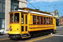
MATA also operates a downtown trolley system with 24 stations along three lines. The trolley system is in the process of expanding into a regional system.
Memphis International Airport
Memphis is served by Memphis International Airport, which handles more cargo than any other airport in the world as of 2007.
The airport is the international cargo hub for FedEx and became a passenger hub for Delta Air Lines after their merger with Northwest Airlines in 2008.[4] Currently, only domestic flights are available for passengers. International flights are only available for cargo. Other passenger airlines providing service to the airport are Air Canada Jazz, AirTran Airways, American Airlines, Continental Airlines, SeaPort Airlines, United Airlines and US Airways.
The Tennessee Air National Guard operates the 164th Airlift Wing at the airport.
Mississippi River port
Memphis also has the 2nd biggest cargo port on the Mississippi River (the 4th biggest inland port in the United States): The International Port of Memphis.[5] The International Port of Memphis covers the Tennessee and Arkansas sides of the Mississippi River from river mile 725 (km 1167) to mile 740 (km 1191). At 15 mi (24 km) long, it has 68 water fronted facilities, 37 of which are terminal facilities for moving products from shore to ship or vice versa. It is 400 mi (644 km) downriver from St. Louis, Missouri and 600 mi (966 km) upriver from New Orleans.[6]
Mississippi River bridges
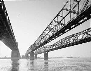
Four rail and highway bridges cross the Mississippi River at Memphis. They are, in order of their opening: the Frisco Bridge, the Harahan Bridge, the Memphis & Arkansas Bridge and the Hernando de Soto Bridge. The piers of the first three bridges had to be lined up for river navigation as they were built side-by-side at a narrow point in the river.
Frisco Bridge
The Frisco Bridge (May 12, 1892) was the longest bridge in North America when it opened and was originally called the Great Bridge at Memphis. This cantilever truss steel railroad bridge was built between 1888–1892. It was designed by George S. Morison, who also designed the Taft Bridge in Washington, D.C..
Harahan Bridge
The Harahan Bridge (July 14, 1916) is a trestle railroad bridge originally built with narrow, one-way wooden cantilevered roadways along the outsides so it could be used for cars. In 1928, sparks from a train ignited and set fire to one of the wooden plank roads. At present only trains use the Harahan Bridge, but a pedestrian walkway and bike path was completed in fall 2016.
Memphis & Arkansas Bridge

The Memphis & Arkansas Bridge (December 17, 1949), carries Interstate 55 and has a pedestrian walkway. The bridge was built between 1945–1949 and is the longest Warren truss- style bridge in the United States. It is listed on the National Historic Register.
Hernando de Soto Bridge
The Hernando de Soto Bridge (August 2, 1973) with its steel arches carries Interstate 40. In 1986, "M" shaped lights became part of the bridge and a Memphis landmark.
The Guinness Book of World Records lists the de Soto bridge for its unique structural "letter" shape. In 2001 the mysterious disappearance and death of Harvard University biophysicist Don Wiley, whose abandoned car was found on the bridge, brought the Hernando de Soto Bridge national headlines.[7]
Bridges overview
| Name | Nickname | Total length | Opening date |
|---|---|---|---|
| Frisco Bridge | 4,887 ft (1,490 m) | 12 May 1892 | |
| Harahan Bridge | 4,973 ft (1,516 m) | 14 July 1916 | |
| Memphis & Arkansas Bridge | "Old Bridge" | 5,222 ft (1,592 m) | 17 Dec. 1949 |
| Hernando de Soto Bridge | "New Bridge"; "Dolly Parton Bridge"; "M Bridge" | 19,535 ft (5,954 m) | 2 Aug. 1973 |
References
| Wikimedia Commons has media related to Transport in Memphis, Tennessee. |
- ↑ Clare, Liz. Pigeon Roost Road. 27 June 2008.
- ↑ Memphis Central Station Pictures Archived 2015-09-26 at the Wayback Machine.
- ↑ Memphis Amtrak Pictures Archived 2007-10-13 at the Wayback Machine.
- ↑ Rushing, Wanda. Memphis: Cotton Fields, Cargo Planes, & Biotechnology Archived 2009-09-04 at the Wayback Machine., Southern Spaces 28 August 2009
- ↑ Top US Inland Ports for 2003 Archived 2009-04-27 at WebCite
- ↑ Port of Memphis website - About Page Archived 2010-03-07 at the Wayback Machine.
- ↑ Don C. Wiley: Obituary and Newspaper Report Archived 2008-01-25 at the Wayback Machine.