High Point Terrace, Memphis
|
High Point Terrace Historic District | |
 High Point Terrace Shops | |
  | |
| Location | Memphis, Tennessee |
|---|---|
| Architect | Smith, J. Frazier; Chandler, Charles K. |
| Architectural style | Late 19th And 20th Century Revivals, Other |
| MPS | Residential Resources of Memphis MPS |
| NRHP reference # | 02001513[1] |
| Added to NRHP | December 12, 2002 |
High Point Terrace is a neighborhood located in the heart of the city of Memphis, Tennessee.
Geography
High Point Terrace is generally geographically defined as being located north of Walnut Grove Road, east of North Highland Street, south of Summer Avenue and bounded on the east by Eastland and Swan Ridge. Sam Cooper Boulevard, a local freeway, cuts the northern section off from the rest of the neighborhood.
Community
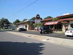
The main thoroughfare extending North from Walnut Grove across Sam Cooper Blvd. to Summer Ave.,(also called High Point Terrace) is several blocks long and contains a small shopping area with a grocery store, family dental office, dry cleaners, pizza shop, barber shop, Deli/Cafe, pub and a few other businesses. Property values in High Point Terrace are some of the highest per square foot in the city of Memphis. There are approximately 4,000 residents and 1,800 homes (most of which are examples of early post-World War II minimal traditional design) in the area.
History
Development in this part of Memphis began around 1900, though very little was developed. The next major development during the early 1940s, but World War II halted development for several years. The whole neighborhood was completed by 1953. The construction of Sam Cooper Boulevard (which was originally to be I-40) destroyed many of the original homes built at the turn of the century. High Point Terrace was added in 2002 to The National Register of Historic Places (NRHP) which is the United States federal government's official list of districts, sites, buildings, structures, and objects deemed worthy of preservation for their historical significance. A property listed in the National Register, or located within a National Register Historic District, may qualify for tax incentives derived from the total value of expenses incurred preserving the property.
References
| Wikimedia Commons has media related to High Point Terrace, Memphis. |
- ↑ National Park Service (2007-01-23). "National Register Information System". National Register of Historic Places. National Park Service.
External links
Coordinates: 35°08′24″N 89°56′19″W / 35.140°N 89.9386°W


| Topics | |
|---|---|
| Lists by states |
|
| Lists by insular areas | |
| Lists by associated states | |
| Other areas | |
| |