Southeastern United States
| Southeast Region of the United States of America | |
|---|---|
| Region | |
| Southeastern United States | |
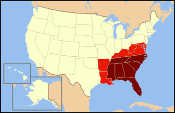 Dark red states are usually included in definitions of the Southeastern United States. Light red states are considered "Southeastern" with less frequency and included in other regions of the United States. | |
| Area | |
| • Total | 580,835 sq mi (1,504,360 km2) |
| • Land | 540,511 sq mi (1,399,920 km2) |
| • Water | 40,324 sq mi (104,440 km2) 6.9% |
| Population (2013) | |
| • Total | 87,438,243 |
| • Density | 150.5/sq mi (58.1/km2) |
| Time zone | EST/CST |
| • Summer (DST) | EDT/CDT |
The Southeastern United States (Spanish: Sureste de Estados Unidos, French: Sud-Est des États-Unis) is the eastern portion of the Southern United States, and the southern portion of the Eastern United States. It comprises 12 states in the southern United States.
Demographics
There is no official Census Bureau definition of the southeastern United States. However, the American Association of Geographers defines the southeastern United States as Alabama, Florida, Georgia, Kentucky, Mississippi, North Carolina, South Carolina, Tennessee, Maryland, Virginia, and West Virginia.[1] The OSBO uses the same states, but includes Arkansas and Louisiana.
Most populous states
The most populous state in the region is Florida (20,612,439), followed by Georgia (10,310,371) and North Carolina (10,146,788).[2]
| State | 2017 Estimate | 2010 Census | Change | Land Area | Density |
|---|---|---|---|---|---|
| Alabama | 4,874,747 | 4,779,736 | +1.99% | 50,645 sq mi (131,171 km2) | 96.3/sq mi (37.2/km2) |
| Arkansas | 3,004,279 | 2,915,918 | +3.03% | 52,035 sq mi (134,771 km2) | 57.7/sq mi (22.3/km2) |
| Florida | 20,984,400 | 18,801,310 | +11.61% | 53,625 sq mi (138,887 km2) | 391.3/sq mi (151.1/km2) |
| Georgia | 10,429,379 | 9,687,653 | +7.66% | 57,513 sq mi (148,959 km2) | 181.3/sq mi (70.0/km2) |
| Kentucky | 4,454,189 | 4,339,367 | +2.65% | 39,486 sq mi (102,269 km2) | 112.8/sq mi (43.6/km2) |
| Louisiana | 4,684,333 | 4,533,372 | +3.33% | 43,204 sq mi (111,898 km2) | 108.4/sq mi (41.9/km2) |
| Mississippi | 2,984,100 | 2,967,297 | +0.57% | 46,923 sq mi (121,531 km2) | 63.6/sq mi (24.6/km2) |
| North Carolina | 10,273,419 | 9,535,483 | +7.74% | 48,618 sq mi (125,920 km2) | 211.3/sq mi (81.6/km2) |
| South Carolina | 5,024,369 | 4,625,364 | +8.63% | 30,061 sq mi (77,857 km2) | 167.1/sq mi (64.5/km2) |
| Tennessee | 6,715,984 | 6,346,105 | +5.83% | 41,235 sq mi (106,798 km2) | 162.9/sq mi (62.9/km2) |
| Virginia | 8,470,020 | 8,001,024 | +5.86% | 39,490 sq mi (102,279 km2) | 214.5/sq mi (82.8/km2) |
| West Virginia | 1,815,857 | 1,852,994 | −2.00% | 24,038 sq mi (62,259 km2) | 75.5/sq mi (29.2/km2) |
| Total | 83,715,076 | 78,385,623 | +6.80% | 526,874 sq mi (1,364,597 km2) | 158.9/sq mi (61.3/km2) |
History
Culture
The predominant culture of the Southeast has its origins with the settlement of the region by British colonists and African slaves in the 17th century, as well as large groups of English, Scots and Ulster-Scots, Germans, Spanish, French, and Acadians in succeeding centuries. Since the late 20th century the New South has emerged as the fastest growing area of the United States economically. Multiculturalism has become mainstream in the Southeastern states. African Americans remain a dominant demographic at around a 30% of the total population of the Southeast. The New South is built upon the metropolitan areas along the interstate 85 corridor. Cities include Birmingham, Atlanta, Greenville, Spartanburg, Charlotte, Greensboro, Winston-Salem and Raleigh-Durham.
Climate
Most of the southeastern part of the United States is dominated by the humid subtropical climate. As one nears the southern portions of Florida, the climate gradually becomes tropical as winters are freeze free and all months have a mean temperature above 64.4 °F (18.0 °C) (the defined coldest monthly mean temperature of tropical climates).
Seasonally, summers are generally hot and humid throughout the entire region. The Bermuda High pumps hot and moist air mass from the tropical Atlantic Ocean and eastern Gulf of Mexico westward toward the southeast United States, creating the typical sultry tropical summers. Daytime highs are often in the upper 80's to lower 90's F.[3][4] Rainfall is summer concentrated along the Gulf Coast and the South Atlantic coast from Norfolk, VA southward, reaching a sharp summer monsoon like pattern over peninsular Florida, with dry winters and wet summers. Sunshine is abundant across the southeastern United States in summer, as the rainfall often comes in quick, but intense downpours. The mid-South, especially Tennessee, and the northern halves of Mississippi, Alabama and Georgia, have maximum monthly rainfall amounts in winter and spring, owing to copious Gulf moisture and clashes between warm, moist air from the Gulf of Mexico and cold, dry air from Canada during the cold season. Here, December, March or April are typically the wettest months; August to October, the driest months (for example, at Tupelo, MS, Huntsville, AL and Memphis, TN).
Winters are cool in the northern areas like Tennessee, Virginia, Maryland, and western North Carolina, with average highs in the 45 °F (7 °C) range in January. Farther south, winters become more mild across interior eastern North and South Carolina, Georgia, and Alabama, with average January highs in the 53 °F (12 °C) range. As one nears the Gulf of Mexico coastal plain and coastal areas of Georgia and South Carolina, winters become warm, with daytime highs near or over 60 °F (16 °C), until far enough south in central Florida where daytime highs are above 70 °F (21 °C). Winters tend to be very dry and sunny across Florida, with a gradual increase in winter rainfall with increasing latitude, especially west of the Appalachian Mountains.
Economy
The Southeast has changed dramatically in the last two generations. Since 1980, there has been a boom in its service economy, manufacturing base, high technology industries, and the financial sector. Examples of this include the surge in tourism in Florida and along the Gulf Coast; numerous new automobile production plants such as Mercedes-Benz in Tuscaloosa, Alabama; Hyundai in Montgomery, Alabama; Toyota Motors in Blue Springs, Mississippi; Kia in West Point, Georgia; the BMW production plant in Greer, South Carolina; Volkswagen in Chattanooga, Tennessee; the GM manufacturing plant in Spring Hill, Tennessee; the Volkswagen manufacturing plant in Pulaski, Virginia;and the Nissan North American headquarters in Franklin, Tennessee; the two largest research parks in the country: Research Triangle Park in the Triangle area of North Carolina (the world's largest) and the Cummings Research Park in Huntsville, Alabama (the world's fourth largest); and the corporate headquarters of Verso Paper in Memphis, as well as FedEx, which is one of the world's largest shipping companies.
Fortune 500 companies having headquarters in the region include 20 in Virginia, 16 in Florida, 15 in North Carolina, and 14 in Georgia. This economic expansion has enabled parts of the South to have of some of the lowest unemployment rates in the United States.[5] In Alabama, there is a large-scale manufacturing project owned by the German steel megacorporation ThyssenKrupp, which operates a massive, state-of-the-art facility in Mobile.
Research and development
Research Triangle Park, in the Raleigh-Durham urban area of North Carolina, has emerged as a major hub of technology, governmental, and biotechnological research and development, as has the Virginia BioTechnology Research Park in Richmond. The Cummings Research Park in the Huntsville, Alabama area is the second largest research complex in the nation. Located in Huntsville is the Redstone Arsenal, United States Army Missile Command, the U.S. Space & Rocket Center, NASA's Marshall Space Flight Center and many other key government, military, and aerospace agencies.
The National High Magnetic Field Laboratory in Tallahassee, Florida, is the largest laboratory in the world devoted to the study of magnetism. The University of South Carolina is currently constructing a research campus in downtown Columbia, and the university is the nation's only National Science Foundation-funded Industry/University Cooperative Research Center for Fuel Cells.[6]
Education
Higher education
The region includes a number of notable universities, public and private, whose research exert influence globally. Chief among these are:
- Auburn University
- Clemson University
- College of William & Mary
- Florida State University
- Georgia Institute of Technology
- Georgia State University
- North Carolina State University
- University of Alabama
- University of Florida
- University of Tennessee
- University of Georgia
- University of Maryland
- University of North Carolina at Chapel Hill
- University of Virginia
- Virginia Polytechnic Institute and State University
There are a number of well-known private institutions, as well. Notable among these are:
- Belmont University
- Davidson College
- Duke University
- Emory University
- Georgetown University
- Johns Hopkins University
- Morehouse College
- Spelman College
- Tulane University
- University of Miami
- University of Richmond
- Vanderbilt University
- Wake Forest University
- Washington and Lee University
The region is home to the greatest number of historically black colleges and universities in the nation. The three largest in the region are North Carolina A&T University, Florida A&M University, and Jackson State University.
Largest cities
These are the largest cities in the Southeastern region of the United States by population, according to the United States Census Bureau:[7]
| Rank | City | State | Population (2015) |
|---|---|---|---|
| 1 | Jacksonvillea[›] | Florida | 868,031 |
| 2 | Charlotte | North Carolina | 827,097 |
| 3 | Washington | District of Columbia | 672,228 |
| 4 | Nashvillea[›] | Tennessee | 660,388 |
| 5 | Memphis | Tennessee | 652,717 |
| 6 | Baltimore | Maryland | 621,849 |
| 7 | Louisvillea[›] | Kentucky | 615,366 |
| 8 | Atlanta | Georgia | 463,878 |
| 9 | Virginia Beach | Virginia | 452,745 |
| 10 | Raleigh | North Carolina | 451,066 |
| 11 | Miami | Florida | 441,003 |
| 12 | New Orleansa[›] | Louisiana | 389,617 |
| 13 | Tampa | Florida | 369,075 |
| 14 | Lexington | Kentucky | 314,488 |
| 15 | Greensboro | North Carolina | 285,342 |
| 16 | Orlando | Florida | 270,394 |
| 17 | Durham | North Carolina | 257,636 |
| 18 | Saint Petersburg | Florida | 257,083 |
| 19 | Norfolk | Virginia | 246,393 |
| 20 | Winston-Salem | North Carolina | 241,218 |
| 21 | Hialeah | Florida | 237,069 |
| 22 | Chesapeake | Virginia | 235,429 |
| 23 | Baton Rouge | Louisiana | 228,590 |
| 24 | Richmond | Virginia | 220,289 |
| 25 | Birmingham | Alabama | 212,461 |
| 26 | Fayetteville | North Carolina | 201,963 |
| 27 | Montgomery | Alabama | 200,602 |
| 28 | Columbus | Georgia | 200,579 |
- ^ a: Jacksonville, Louisville, Nashville and New Orleans are consolidated city-counties/parishes. Therefore the population given is for the entire city excluding other incorporated places lying within the county limits.
Metropolitan Statistical Areas
These are the metropolitan areas of the Southeastern region which exceed 1 million in population according to the United States Census Bureau's 2016 estimates:[8]
Combined Statistical Areas
Beyond Megalopolis by Virginia Tech's Metropolitan Institute, an attempt to update Jean Gottmann's work with current trends, defines two "megapolitan areas" contained within the Southeast, out of a total of ten such areas in the United States:
- "Piedmont" extending from North Carolina to Alabama
- "Peninsula" covering South Florida and Central Florida
Two others tie some areas on the margins of the Southeast to urban centers in other regions:
- "Gulf Coast" extending as far east as the western tip of Florida
- "Northeast" including much of Maryland and eastern Virginia
These are the combined statistical areas of the Southeastern region which exceed 1 million in population according to the United States Census Bureau's 2016 estimates. Note that the metropolitan areas of Tampa and Richmond are not included in any CSAs, so they are included in the table without constituent areas.[9]
Sports
Although American football is prevalent across the United States, it is especially pervasive in the Southeast. With a total of nine (9) franchises — the Atlanta Falcons, the Baltimore Ravens, the Carolina Panthers, the Jacksonville Jaguars, the Miami Dolphins, the New Orleans Saints, the Tampa Bay Buccaneers, the Tennessee Titans, and the Washington Redskins — across the region, the National Football League (NFL) maintains a stronger commercial presence than any other major North American professional sports league.
The Southeast has seven (7) National Basketball Association (NBA) franchises: the Atlanta Hawks, the Charlotte Hornets, the Memphis Grizzlies, the Miami Heat, the New Orleans Pelicans, the Orlando Magic, and the Washington Wizards.
Major League Baseball (MLB) maintains five (5) teams in the Southeast: the Atlanta Braves, the Baltimore Orioles, the Miami Marlins, the Tampa Bay Rays, and the Washington Nationals.
The Southeast has five (5) National Hockey League (NHL) franchises: the Carolina Hurricanes, the Florida Panthers, the Nashville Predators, the Tampa Bay Lightning, and the Washington Capitals.
Major League Soccer currently holds three (3) clubs — Atlanta United FC, DC United, and Orlando City SC— in the region. This number will increase to five (5) when Nashville's new club and David Beckham's new club in Miami begin play in March 2020.
The Atlantic Coast Conference is an NCAA Division 1 conference of mainly Southeastern college teams, including the Florida State Seminoles, Louisville Cardinals, Miami Hurricanes, Clemson Tigers and Georgia Tech Yellow Jackets, Wake Forest Demon Deacons, Duke Blue Devils, North Carolina Tar Heels, NC State Wolfpack, Virginia Tech Hokies, and Virginia Cavaliers. The Sugar Bowl, Orange Bowl, Peach Bowl, and Citrus Bowl are notable college football bowls held in Southeastern cities.
The Southeastern Conference is also an NCAA Division 1 conference of Southeastern college teams, including the Alabama Crimson Tide, Auburn Tigers, Kentucky Wildcats, Ole Miss Rebels, Florida Gators, South Carolina Gamecocks, Tennessee Volunteers and Georgia Bulldogs, Mississippi State Bulldogs, and Vanderbilt Commodores.
The majority of NASCAR teams are headquartered in the Charlotte area along with the sports operations headquarters and media outlets. Tracks in the region include Daytona International Speedway, Homestead-Miami Speedway, Talladega Superspeedway, Bristol Motor Speedway, Charlotte Motor Speedway, Atlanta Motor Speedway, Darlington Raceway, Kentucky Speedway, Martinsville Speedway, and Richmond International Speedway.
The southeast also hosts two of the three legs of the American Triple Crown. The Kentucky derby, in Kentucky. The Preakness Stakes are also located in the Southeast, being run in Baltimore, the Derby is considered the western leg of the crown and the Preakness is traditionally considered the southern leg.
See also
- Southeastern mixed forests – Southeastern habitat
- Hammock (ecology) – Southeastern habitat
- East Coast of the United States – the southern Eastern Seaboard portion
References
- ↑ Southeastern Division of the Association of American Geographers
- ↑ "Annual Estimates of the Resident Population: April 1, 2010 to July 1, 2016 (PEPANNRES): All States within the United States and Puerto Rico". American Factfinder. U.S. Census Bureau. Retrieved May 2, 2017.
- ↑ "Miami, Florida Temperature Averages". Weatherbase. Retrieved 29 December 2015.
- ↑ "Virginia Beach, Virginia Temperature Averages". Weatherbase. Retrieved 29 December 2015.
- ↑ "State jobless rate below US average". The Decatur Daily. August 19, 2005. Archived from the original on September 28, 2007. Retrieved 2007-02-12.
- ↑ "Business Partnership Opportunities". Innovista.sc.edu. Retrieved 2013-12-13.
- ↑ "Annual Estimates of the Resident Population for Incorporated Places of 50,000 or More, Ranked by July 1, 2015 Population: April 1, 2010 to July 1, 2015 - United States -- Places of 50,000+ Population (PEPANNRSIP)". American Factfinder. United States Census Bureau, Population Division. Retrieved May 2, 2017.
- ↑ "Annual Estimates of the Resident Population: April 1, 2010 to July 1, 2016 (PEPANNRES): All Metropolitan and Micropolitan Statistical Areas within United States and Puerto Rico". American Factfinder. U.S. Census Bureau. Retrieved May 2, 2017.
- ↑ "Annual Estimates of the Resident Population: April 1, 2010 to July 1, 2016 (PEPANNRES)". American Factfinder. United States Census Bureau. Retrieved May 2, 2017.
External links
| Wikimedia Commons has media related to Southeastern United States. |
- Flora Atlas of the Southeastern United States – by the North Carolina Botanical Garden & University of North Carolina Herbarium (NCU).
- Sea Level Changes in the Southeastern United States. Past, Present, and Future – University of South Florida (August 2011)
- Britannica Southeast U.S. – video on YouTube