San Felices de los Gallegos
| San Felices de los Gallegos | |||
|---|---|---|---|
| Municipality | |||
| |||
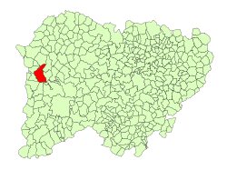 Location in Salamanca | |||
| Coordinates: 45°51′1″N 6°42′23″W / 45.85028°N 6.70639°WCoordinates: 45°51′1″N 6°42′23″W / 45.85028°N 6.70639°W | |||
| Country | Spain | ||
| Autonomous community | Castile and León | ||
| Province | Salamanca | ||
| Comarca | El Abadengo | ||
| Government | |||
| • Mayor | Francisco de la Cruz Suarez (People's Party) | ||
| Area[1] | |||
| • Total | 81 km2 (31 sq mi) | ||
| Elevation[1] | 667 m (2,188 ft) | ||
| Population (2016)[2] | |||
| • Total | 442 | ||
| • Density | 5.5/km2 (14/sq mi) | ||
| Time zone | UTC+1 (CET) | ||
| • Summer (DST) | UTC+2 (CEST) | ||
| Postal code | 37270 | ||

San Felices de los Gallegos is a village and large municipality in the province of Salamanca, western Spain, part of the autonomous community of Castile and León. It is located 102 kilometers from the provincial capital city of Salamanca and has a population of 442 people. It is situated within the Arribes del Duero Natural Park.
History
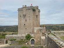
As a result of the Treaty of Alcañices in 1297 the village became part of the Kingdom of Portugal, with the name of São Felix de Galegos, along with other Spanish towns: Hermisende (Ermesende in Portuguese), Salvaterra de Miño (Salvaterra do Minho), Olivenza (Olivença; including the current municipality of Táliga). The Portuguese held San Felices de los Gallegos until 1327 and occupied it briefly c. 1370 and again c. 1476.
Geography
The municipality covers an area of 81 km². It lies 667 meters above sea level and the post code is 37270.[1]
See also
References
- 1 2 3 "Municipio:San Felices de los Gallegos". www.lasalina.es. Retrieved 2017-11-05.
- ↑ "Salamanca: Población por municipios y sexo". www.ine.es (in Spanish). Retrieved 2017-11-05.