Villoruela
| Villoruela | |||
|---|---|---|---|
| Municipality | |||
| |||
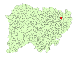 Location in Salamanca | |||
| Coordinates: 41°0′29″N 5°23′40″W / 41.00806°N 5.39444°WCoordinates: 41°0′29″N 5°23′40″W / 41.00806°N 5.39444°W | |||
| Country | Spain | ||
| Autonomous community | Castile and León | ||
| Province | Salamanca | ||
| Comarca | Las Villas | ||
| Government | |||
| • Mayor | Florentino Hernández García (PSOE) | ||
| Area[1] | |||
| • Total | 17 km2 (7 sq mi) | ||
| Elevation[1] | 824 m (2,703 ft) | ||
| Population (2016)[2] | |||
| • Total | 819 | ||
| • Density | 48/km2 (120/sq mi) | ||
| Time zone | UTC+1 (CET) | ||
| • Summer (DST) | UTC+2 (CEST) | ||
| Postal code | 37338 | ||

Villoruela is a municipality located in the province of Salamanca, Castile and León, Spain.
References
- 1 2 "Municipio:Villoruela". www.lasalina.es. Retrieved 2017-11-02.
- ↑ "Salamanca: Población por municipios y sexo". www.ine.es (in Spanish). Retrieved 2017-11-02.
This article is issued from
Wikipedia.
The text is licensed under Creative Commons - Attribution - Sharealike.
Additional terms may apply for the media files.