Mancera de Abajo
| Mancera de Abajo | |||
|---|---|---|---|
| Municipality | |||
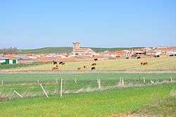 Panorama of Mancera de Abajo | |||
| |||
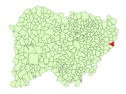 Location in Salamanca | |||
 Mancera de Abajo Location in Spain | |||
| Coordinates: 40°50′N 5°12′W / 40.833°N 5.200°WCoordinates: 40°50′N 5°12′W / 40.833°N 5.200°W | |||
| Country | Spain | ||
| Autonomous community | Castile and León | ||
| Province | Salamanca | ||
| Comarca | Tierra de Peñaranda | ||
| Government | |||
| • Alcalde (Mayor) | Juan Carlos Zaballos Martínez, PP | ||
| Area[1] | |||
| • Total | 23 km2 (9 sq mi) | ||
| Elevation[1] | 898 m (2,946 ft) | ||
| Population (2016)[2] | |||
| • Total | 225 | ||
| • Density | 9.8/km2 (25/sq mi) | ||
| Time zone | UTC+1 (CET) | ||
| • Summer (DST) | UTC+2 (CEST) | ||
| Postal code | 37315 | ||


Mancera de Abajo is a village and municipality in the province of Salamanca, western Spain, part of the autonomous community of Castile-Leon. It is located 48 kilometres (30 mi) from the provincial capital city of Salamanca and has a population of 225 people.
Geography
The municipality covers an area of 23 km2 (8.9 sq mi). It lies 898 metres (2,946 ft) above sea level and the post code is 37315.
Economy
- The basis of the economy is agriculture.
See also
References
- 1 2 "Municipio:Mancera de Abajo". www.lasalina.es (in Spanish). Retrieved 2017-11-06.
- ↑ "Salamanca: Población por municipios y sexo". www.ine.es (in Spanish). Retrieved 2017-11-06.
This article is issued from
Wikipedia.
The text is licensed under Creative Commons - Attribution - Sharealike.
Additional terms may apply for the media files.