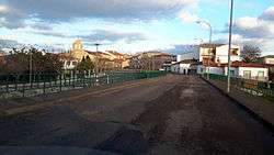
Sancti-Spíritus, Salamanca
| Sancti-Spíritus | ||
|---|---|---|
| Municipality | ||
 | ||
| ||
.svg.png) Location in Salamanca | ||
 Sancti-Spíritus Location in Salamanca | ||
| Coordinates: 40°42′19″N 6°24′03″W / 40.70528°N 6.40083°WCoordinates: 40°42′19″N 6°24′03″W / 40.70528°N 6.40083°W | ||
| Country |
| |
| Autonomous Community |
| |
| Province | Salamanca | |
| Comarca | Comarca de Ciudad Rodrigo | |
| Subcomarca | Campo del Yeltes | |
| Government | ||
| • Type | Mayor-council | |
| • Body | Ayuntamiento de Sancti-Spíritus | |
| • Mayor | Bienvenido Garduño Sánchez (PP) | |
| Area[1] | ||
| • Total | 142 km2 (55 sq mi) | |
| Elevation[1] | 756 m (2,480 ft) | |
| Population (2016)[2] | ||
| • Total | 854 | |
| • Density | 6.0/km2 (16/sq mi) | |
| Time zone | UTC+1 (CET) | |
| • Summer (DST) | UTC+2 (CEST) | |
| Postcode | 37470 | |
| Website | www.ayto-sanctispiritus.com | |
Sancti-Spiritus is a municipality in the province of Salamanca, in the autonomous community of Castile-Leon, Spain. It is 70 km away from Salamanca, the capital of the province. It is situated 756 m above the sea level.
The area of the municipality is 142 km² and it ranks 4th among the municipalities in the provinces of Salamanca after Ciudad Rodrigo, Castillejo de Martín Viejo, and Ledesma.
As of 2016 its population is 854 inhabitants and the postal code 37470.
References
- 1 2 "Municipio:Sancti-Spíritus". www.lasalina.es. Retrieved 2017-11-02.
- ↑ "Salamanca: Población por municipios y sexo". www.ine.es (in Spanish). Retrieved 2017-11-02.
This article is issued from
Wikipedia.
The text is licensed under Creative Commons - Attribution - Sharealike.
Additional terms may apply for the media files.
.svg.png)