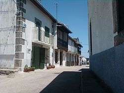
Horcajo de Montemayor
| Horcajo de Montemayor | |
|---|---|
| Municipality | |
 | |
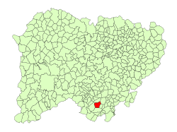 Location in Salamanca | |
 Horcajo de Montemayor Location in Spain | |
| Coordinates: 40°25′17″N 5°53′37″W / 40.42139°N 5.89361°WCoordinates: 40°25′17″N 5°53′37″W / 40.42139°N 5.89361°W | |
| Country | Spain |
| Autonomous community | Castile and León |
| Province | Salamanca |
| Comarca | Sierra de Béjar |
| Government | |
| • Mayor | Domingo Sánchez (People's Party) |
| Area[1] | |
| • Total | 30 km2 (10 sq mi) |
| Elevation[1] | 738 m (2,421 ft) |
| Population (2016)[2] | |
| • Total | 154 |
| • Density | 5.1/km2 (13/sq mi) |
| Time zone | UTC+1 (CET) |
| • Summer (DST) | UTC+2 (CEST) |
| Postal code | 37712 |
Horcajo de Montemayor is a village and municipality in the province of Salamanca, western Spain, part of the autonomous community of Castile-Leon. It is located 90 kilometres (56 mi) from the provincial capital city of Salamanca and has a population of 154 people.
Geography
The municipality covers an area of 30 km2 (12 sq mi). It lies 738 metres (2,421 ft) above sea level.
See also
References
- 1 2 "Municipio:Horcajo de Montemayor". www.lasalina.es (in Spanish). Retrieved 2017-11-01.
- ↑ "Salamanca: Población por municipios y sexo". www.ine.es (in Spanish). Retrieved 2017-11-01.
This article is issued from
Wikipedia.
The text is licensed under Creative Commons - Attribution - Sharealike.
Additional terms may apply for the media files.