Berrocal de Huebra
| Berrocal de Huebra | |||
|---|---|---|---|
| Municipality | |||
| |||
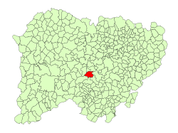 Location in Salamanca | |||
 Berrocal de Huebra Location in Spain | |||
| Coordinates: 40°43′01″N 5°59′58″W / 40.71694°N 5.99944°WCoordinates: 40°43′01″N 5°59′58″W / 40.71694°N 5.99944°W | |||
| Country | Spain | ||
| Autonomous community | Castile and León | ||
| Province | Salamanca | ||
| Comarca | Campo de Salamanca | ||
| Government | |||
| • Mayor | Luis Marcos Lorenzo (People's Party) | ||
| Area[1] | |||
| • Total | 39 km2 (15 sq mi) | ||
| Elevation[1] | 899 m (2,949 ft) | ||
| Population (2016)[2] | |||
| • Total | 68 | ||
| • Density | 1.7/km2 (4.5/sq mi) | ||
| Time zone | UTC+1 (CET) | ||
| • Summer (DST) | UTC+2 (CEST) | ||
| Postal code | 37609 | ||

Berrocal de Huebra is a village and municipality in the province of Salamanca, western Spain, part of the autonomous community of Castile-Leon. It is 43 kilometres (27 mi) from the provincial capital city of Salamanca and has a population of 68 people. It lies 899 metres (2,949 ft) above sea level and the post code is 37609.
References
- 1 2 "Municipio:Berrocal de Huebra". www.lasalina.es (in Spanish). Retrieved 2017-10-28.
- ↑ "Salamanca: Población por municipios y sexo". www.ine.es (in Spanish). Retrieved 2017-10-28.
This article is issued from
Wikipedia.
The text is licensed under Creative Commons - Attribution - Sharealike.
Additional terms may apply for the media files.