Táliga
| Táliga | |||
|---|---|---|---|
| Municipality | |||
 | |||
| |||
 Táliga Location in Spain/Portugal | |||
| Coordinates: 38°31′N 7°0′W / 38.517°N 7.000°WCoordinates: 38°31′N 7°0′W / 38.517°N 7.000°W | |||
| Country | Disputed: | ||
| Spanish community | Extremadura | ||
| Spanish Province | Badajoz | ||
| Portuguese district | Évora | ||
| Government | |||
| • Alcalde | Inmaculada Bonilla Martínez (2007) (PSOE) | ||
| Area | |||
| • Total | 31 km2 (12 sq mi) | ||
| Elevation | 315 m (1,033 ft) | ||
| Population (2009) | |||
| • Total | 801 | ||
| • Density | 26/km2 (67/sq mi) | ||
| Demonym(s) | Taligueño/ña | ||
| Time zone | UTC+1 (CET) | ||
| • Summer (DST) | UTC+2 (CEST) | ||
| Postal code | 06133 | ||
| Official language(s) | Spanish | ||
| Website | Official website | ||
.svg.png)

Táliga (Spanish: [ˈtaliɣa] or Talega (Portuguese: [tɐˈlɛɣɐ]) is a town and municipality located border area between Portugal and Spain. Like Olivenza, Táliga is part of the province of Badajoz, in the Spanish autonomous community of Extremadura, although this is disputed and unrecognized by Portugal, which considers Táliga as being de jure part of the occupied concelho of Olivenza since 1801.
Under Portuguese administration, Táliga was a freguesia (parish) of the concelho (municipality) of Olivenza. It became an independent municipality in 1850, already under Spanish administration.
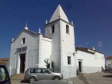
Church in Táliga
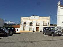
House in Táliga
External links
| Wikimedia Commons has media related to Táliga. |
This article is issued from
Wikipedia.
The text is licensed under Creative Commons - Attribution - Sharealike.
Additional terms may apply for the media files.