El Cabaco
| El Cabaco | |||
|---|---|---|---|
| Municipality | |||
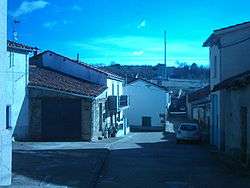 Calle Larga, street in El Cabaco | |||
| |||
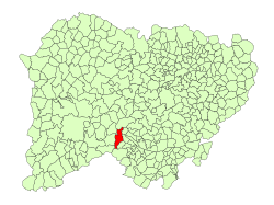 Location in Salamanca | |||
 El Cabaco Location in Spain | |||
| Coordinates: 40°34′N 6°08′W / 40.567°N 6.133°WCoordinates: 40°34′N 6°08′W / 40.567°N 6.133°W | |||
| Country | Spain | ||
| Autonomous community | Castile and León | ||
| Province | Salamanca | ||
| Comarca | Sierra de Francia | ||
| Government | |||
| • Mayor | Prudencio San Pablo García (PSOE) | ||
| Area[1] | |||
| • Total | 47 km2 (18 sq mi) | ||
| Elevation[1] | 958 m (3,143 ft) | ||
| Population (2016)[2] | |||
| • Total | 248 | ||
| • Density | 5.3/km2 (14/sq mi) | ||
| Time zone | UTC+1 (CET) | ||
| • Summer (DST) | UTC+2 (CEST) | ||
| Postal code | 37620 | ||
.svg.png)
El Cabaco is a village and municipality in the province of Salamanca, western Spain, part of the autonomous community of Castile-Leon. It is located 68 kilometres (42 mi) from the provincial capital city of Salamanca and has a population of 248 people.
Geography
The municipality covers an area of 47 km2 (18 sq mi). It lies 958 metres (3,143 ft) above sea level and the post code is 37620.
References
- 1 2 "Municipio: Cabaco (El)". www.lasalina.es (in Spanish). Retrieved 2017-11-07.
- ↑ "Salamanca: Población por municipios y sexo". www.ine.es (in Spanish). Retrieved 2017-11-07.
This article is issued from
Wikipedia.
The text is licensed under Creative Commons - Attribution - Sharealike.
Additional terms may apply for the media files.