Coca de Alba
| Coca de Alba | |||
|---|---|---|---|
| municipality | |||
| |||
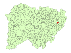 Location in Salamanca | |||
 Coca de Alba Location in Spain | |||
| Coordinates: 40°52′38″N 5°21′44″W / 40.87722°N 5.36222°WCoordinates: 40°52′38″N 5°21′44″W / 40.87722°N 5.36222°W | |||
| Country | Spain | ||
| Autonomous community | Castile and León | ||
| Province | Salamanca | ||
| Comarca | Tierra de Alba | ||
| Government | |||
| • Mayor | Antonio González Sánchez (People's Party) | ||
| Area[1] | |||
| • Total | 10 km2 (4 sq mi) | ||
| Elevation[1] | 837 m (2,746 ft) | ||
| Population (2016)[2] | |||
| • Total | 99 | ||
| • Density | 9.9/km2 (26/sq mi) | ||
| Time zone | UTC+1 (CET) | ||
| • Summer (DST) | UTC+2 (CEST) | ||
| Postal code | 37830 | ||
Coca de Alba is a municipality in the province of Salamanca, western Spain, part of the autonomous community of Castile-Leon. It is located 35 kilometres (22 mi) from the provincial capital city of Salamanca and has a population of 99 people.
Geography
The municipality covers an area of 10 km2 (3.9 sq mi). It lies 837 metres (2,746 ft) above sea level and the post code is 37830.
References
- 1 2 "Municipio:Coca de Alba". www.lasalina.es (in Spanish). Retrieved 2017-10-27.
- ↑ "Salamanca: Población por municipios y sexo". www.ine.es (in Spanish). Retrieved 2017-10-27.
This article is issued from
Wikipedia.
The text is licensed under Creative Commons - Attribution - Sharealike.
Additional terms may apply for the media files.