La Fuente de San Esteban
| La Fuente de San Esteban | |||
|---|---|---|---|
| Municipality | |||
| |||
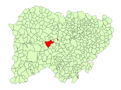 Location in Salamanca | |||
| Coordinates: 40°48′1″N 6°15′0″W / 40.80028°N 6.25000°WCoordinates: 40°48′1″N 6°15′0″W / 40.80028°N 6.25000°W | |||
| Country | Spain | ||
| Autonomous community | Castile and León | ||
| Province | Salamanca | ||
| Comarca | Comarca de Ciudad Rodrigo | ||
| Subcomarca | Campo del Yeltes | ||
| Government | |||
| • Mayor | Manuel Rufino García Núñez (People's Party) | ||
| Area[1] | |||
| • Total | 77 km2 (30 sq mi) | ||
| Elevation[1] | 770 m (2,530 ft) | ||
| Population (2016)[2] | |||
| • Total | 1,358 | ||
| • Density | 18/km2 (46/sq mi) | ||
| Time zone | UTC+1 (CET) | ||
| • Summer (DST) | UTC+2 (CEST) | ||
| Postal code | 37200 | ||

La Fuente de San Esteban is a village and large municipality in the province of Salamanca, western Spain, part of the autonomous community of Castile-Leon. It is located 54 kilometres (34 mi) from the provincial capital city of Salamanca and has a population of 1,358 people.
The town formerly had a direct rail connection to Oporto in Portugal via the Douro railway line. The section between La Fuente de San Estaban and the border with Portugal was closed in 1984.
Geography
The municipality covers an area of 77 km2 (30 sq mi). It lies 770 metres (2,530 ft) above sea level and the post code is 37200. The municipality contains the smaller villages of Boadilla (197 people), Muñoz (99 inhabitants) and Santa Olalla de Yeltes.
See also
References
- 1 2 "Municipio:Fuente de San Esteban (La)". www.lasalina.es. Retrieved 2017-11-02.
- ↑ "Salamanca: Población por municipios y sexo". www.ine.es (in Spanish). Retrieved 2017-11-02.
This article is issued from
Wikipedia.
The text is licensed under Creative Commons - Attribution - Sharealike.
Additional terms may apply for the media files.