Zorita de la Frontera
| Zorita de la Frontera | |||
|---|---|---|---|
| Municipality | |||
| |||
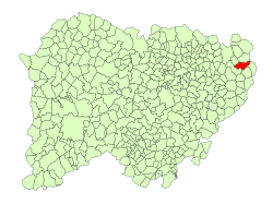 Location in Salamanca | |||
 Zorita de la Frontera Location in Spain | |||
| Coordinates: 41°00′51″N 5°12′50″W / 41.01417°N 5.21389°WCoordinates: 41°00′51″N 5°12′50″W / 41.01417°N 5.21389°W | |||
| Country | Spain | ||
| Autonomous community | Castile and León | ||
| Province | Salamanca | ||
| Comarca | Tierra de Peñaranda | ||
| Government | |||
| • Mayor | José Manuel Partearroyo Rodero (People's Party) | ||
| Area[1] | |||
| • Total | 32 km2 (12 sq mi) | ||
| Elevation[1] | 831 m (2,726 ft) | ||
| Population (2016)[2] | |||
| • Total | 183 | ||
| • Density | 5.7/km2 (15/sq mi) | ||
| Time zone | UTC+1 (CET) | ||
| • Summer (DST) | UTC+2 (CEST) | ||
| Postal code | 37408 | ||

Zorita de la Frontera is a municipality in the province of Salamanca, western Spain, part of the autonomous community of Castile and León. It is located 54 kilometers from the city of Salamanca.[1]
References
- 1 2 3 "Municipio:Zorita de la Frontera". www.lasalina.es (in Spanish). Retrieved 2017-10-29.
- ↑ "Salamanca: Población por municipios y sexo". www.ine.es (in Spanish). Retrieved 2017-10-29.
This article is issued from
Wikipedia.
The text is licensed under Creative Commons - Attribution - Sharealike.
Additional terms may apply for the media files.