Saint-Armel, Morbihan
| Saint-Armel Sant-Armael | ||
|---|---|---|
| Commune | ||
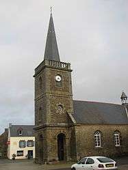 The church in Saint-Armel | ||
| ||
 Saint-Armel Location within Brittany region  Saint-Armel | ||
| Coordinates: 47°34′24″N 2°42′34″W / 47.5733°N 2.7094°WCoordinates: 47°34′24″N 2°42′34″W / 47.5733°N 2.7094°W | ||
| Country | France | |
| Region | Brittany | |
| Department | Morbihan | |
| Arrondissement | Vannes | |
| Canton | Séné | |
| Intercommunality | Golfe du Morbihan - Vannes Agglomération | |
| Government | ||
| • Mayor (2008—2014) | Dominique Plat | |
| Area1 | 7.95 km2 (3.07 sq mi) | |
| Population (1999)2 | 707 | |
| • Density | 89/km2 (230/sq mi) | |
| Time zone | UTC+1 (CET) | |
| • Summer (DST) | UTC+2 (CEST) | |
| INSEE/Postal code | 56205 /56450 | |
| Elevation | 0–17 m (0–56 ft) | |
|
1 French Land Register data, which excludes lakes, ponds, glaciers > 1 km2 (0.386 sq mi or 247 acres) and river estuaries. 2 Population without double counting: residents of multiple communes (e.g., students and military personnel) only counted once. | ||
.svg.png)
Saint-Armel (Breton: Sant-Armael) is a commune in the Morbihan department of Brittany in north-western France.
Demographics
Inhabitants of Saint-Armel are called in French Armelois.
See also
References
- Mayors of Morbihan Association (in French)
- INSEE commune file
External links
| Wikimedia Commons has media related to Saint-Armel (Morbihan). |
- French Ministry of Culture list for Saint-Armel (in French)
- Map of Saint-Armel on Michelin (in English)
This article is issued from
Wikipedia.
The text is licensed under Creative Commons - Attribution - Sharealike.
Additional terms may apply for the media files.