Camors
| Camors Kamorzh | ||
|---|---|---|
| Commune | ||
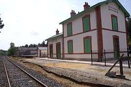 The Lambel - Camors railway station | ||
| ||
 Camors Location within Brittany region  Camors | ||
| Coordinates: 47°50′55″N 2°59′59″W / 47.8486°N 2.9997°WCoordinates: 47°50′55″N 2°59′59″W / 47.8486°N 2.9997°W | ||
| Country | France | |
| Region | Brittany | |
| Department | Morbihan | |
| Arrondissement | Lorient | |
| Canton | Pluvigner | |
| Intercommunality | Pays d'Auray | |
| Government | ||
| • Mayor (2008—2014) | Bernadette Desjardins | |
| Area1 | 37.09 km2 (14.32 sq mi) | |
| Population (1999)2 | 2,353 | |
| • Density | 63/km2 (160/sq mi) | |
| Time zone | UTC+1 (CET) | |
| • Summer (DST) | UTC+2 (CEST) | |
| INSEE/Postal code | 56031 /56330 | |
| Elevation | 27–137 m (89–449 ft) | |
|
1 French Land Register data, which excludes lakes, ponds, glaciers > 1 km2 (0.386 sq mi or 247 acres) and river estuaries. 2 Population without double counting: residents of multiple communes (e.g., students and military personnel) only counted once. | ||
.svg.png)
Camors (Kamorzh in Breton) is a commune in the Morbihan department of Brittany in north-western France.
Geography
With the River Tarun, its main tributary, the Ével forms the commune's northern border.
Demographics
Inhabitants of Camors are called in French Camoriens.
Points of interest
See also
References
- Mayors of Morbihan Association (in French)
- INSEE commune file
External links
| Wikimedia Commons has media related to Camors. |
- Official site (in French)
- French Ministry of Culture list for Camors (in French)
- Map of Camors on Michelin (in English)
This article is issued from
Wikipedia.
The text is licensed under Creative Commons - Attribution - Sharealike.
Additional terms may apply for the media files.