Moréac
| Moréac Mourieg | ||
|---|---|---|
| Commune | ||
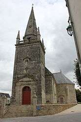 The Church of Saint-Cyr, in Moréac | ||
| ||
 Moréac Location within Brittany region  Moréac | ||
| Coordinates: 47°55′N 2°49′W / 47.92°N 2.82°WCoordinates: 47°55′N 2°49′W / 47.92°N 2.82°W | ||
| Country | France | |
| Region | Brittany | |
| Department | Morbihan | |
| Arrondissement | Pontivy | |
| Canton | Moréac | |
| Government | ||
| • Mayor (2008—2014) | André Allioux | |
| Area1 | 60.30 km2 (23.28 sq mi) | |
| Population (1999)2 | 2,893 | |
| • Density | 48/km2 (120/sq mi) | |
| Time zone | UTC+1 (CET) | |
| • Summer (DST) | UTC+2 (CEST) | |
| INSEE/Postal code | 56140 /56500 | |
| Elevation | 57–149 m (187–489 ft) | |
|
1 French Land Register data, which excludes lakes, ponds, glaciers > 1 km2 (0.386 sq mi or 247 acres) and river estuaries. 2 Population without double counting: residents of multiple communes (e.g., students and military personnel) only counted once. | ||
.svg.png)
Moréac (Breton: Mourieg) is a commune in the Morbihan department of Brittany in north-western France.
Geography
The Ruisseau de Kerropert forms part of the commune's eastern border, then flows into the Ével, which forms its northern border.
Demographics
Inhabitants of Moréac are called in French Moréacois.
Breton language
In 2008, there was 22,12% of the children attended the bilingual schools in primary education.[1]
See also
References
- Mayors of Morbihan Association (in French)
- INSEE commune file
- ↑ (in French) Ofis ar Brezhoneg: Enseignement bilingue
External links
| Wikimedia Commons has media related to Moréac. |
- Official website (in French)
- French Ministry of Culture list for Moréac (in French)
- Map of Moréac on Michelin (in English)
This article is issued from
Wikipedia.
The text is licensed under Creative Commons - Attribution - Sharealike.
Additional terms may apply for the media files.