Cruguel
| Cruguel Krugell | ||
|---|---|---|
| Commune | ||
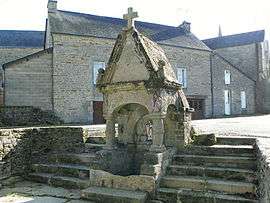 The Fountain of Saint Brieuc, in Cruguel | ||
| ||
 Cruguel Location within Brittany region  Cruguel | ||
| Coordinates: 47°52′46″N 2°35′39″W / 47.8794°N 2.5942°WCoordinates: 47°52′46″N 2°35′39″W / 47.8794°N 2.5942°W | ||
| Country | France | |
| Region | Brittany | |
| Department | Morbihan | |
| Arrondissement | Pontivy | |
| Canton | Ploërmel | |
| Intercommunality | Pays de Josselin | |
| Government | ||
| • Mayor (2008—2014) | Henri Ribouchon | |
| Area1 | 17.17 km2 (6.63 sq mi) | |
| Population (1999)2 | 595 | |
| • Density | 35/km2 (90/sq mi) | |
| Time zone | UTC+1 (CET) | |
| • Summer (DST) | UTC+2 (CEST) | |
| INSEE/Postal code | 56051 /56420 | |
| Elevation | 52–166 m (171–545 ft) | |
|
1 French Land Register data, which excludes lakes, ponds, glaciers > 1 km2 (0.386 sq mi or 247 acres) and river estuaries. 2 Population without double counting: residents of multiple communes (e.g., students and military personnel) only counted once. | ||
.svg.png)
Cruguel (Krugell in Breton) is a commune in the Morbihan department of Brittany in north-western France.
Demographics
Inhabitants of Cruguel are called in French Cruguellois.
See also
References
- Mayors of Morbihan Association (in French)
- INSEE commune file
External links
| Wikimedia Commons has media related to Cruguel. |
- French Ministry of Culture list for Cruguel (in French)
- Map of Cruguel on Michelin (in English)
This article is issued from
Wikipedia.
The text is licensed under Creative Commons - Attribution - Sharealike.
Additional terms may apply for the media files.