Saint-Gildas-de-Rhuys
| Saint-Gildas-de-Rhuys Lokentaz | ||
|---|---|---|
| Commune | ||
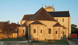 Saint Gildas church | ||
| ||
 Saint-Gildas-de-Rhuys Location within Brittany region  Saint-Gildas-de-Rhuys | ||
| Coordinates: 47°30′03″N 2°50′12″W / 47.5008°N 2.8367°WCoordinates: 47°30′03″N 2°50′12″W / 47.5008°N 2.8367°W | ||
| Country | France | |
| Region | Brittany | |
| Department | Morbihan | |
| Arrondissement | Vannes | |
| Canton | Séné | |
| Intercommunality | Golfe du Morbihan - Vannes Agglomération | |
| Government | ||
| • Mayor (2008—2014) | Dominique Vanard | |
| Area1 | 15.28 km2 (5.90 sq mi) | |
| Population (1999)2 | 1,436 | |
| • Density | 94/km2 (240/sq mi) | |
| Time zone | UTC+1 (CET) | |
| • Summer (DST) | UTC+2 (CEST) | |
| INSEE/Postal code | 56214 /56730 | |
| Elevation | 0–42 m (0–138 ft) | |
|
1 French Land Register data, which excludes lakes, ponds, glaciers > 1 km2 (0.386 sq mi or 247 acres) and river estuaries. 2 Population without double counting: residents of multiple communes (e.g., students and military personnel) only counted once. | ||
.svg.png)
Saint-Gildas-de-Rhuys (Breton: Lokentaz) is a commune in the Morbihan department of Brittany in north-western France.
Its French name refers to Saint Gildas, who founded the abbey of Saint-Gildas-de-Ruys on the Rhuys Peninsula in the 6th century. From 920 to 1008, the Norman raids forced the monks to bring the relics of the saint to the abbey of Saint-Gildas of Châteauroux that they founded under the protection of the prince Ebbes of Déols.
Demographics
Inhabitants of Saint-Gildas-de-Rhuys are called in French Gildasiens.
Burials
- Saint Gildas (d.570)
- Saint Felix of Rhuys (d.1038)
- Saint Goustan (also called Saint Gulstan, d.1040)
- Alienor de Bretagne, daughter of John I, Duke of Brittany (d.1249)
- Jeanne de Bretagne, daughter of John IV, Duke of Brittany (d.1388)
See also
References
- Mayors of Morbihan Association (in French)
- INSEE commune file
External links
- French Ministry of Culture list for Saint-Gildas-de-Rhuys (in French)
- Map of Saint-Gildas-de-Rhuys on Michelin (in English)
| Wikimedia Commons has media related to Saint-Gildas-de-Rhuys. |
| Authority control |
|---|
This article is issued from
Wikipedia.
The text is licensed under Creative Commons - Attribution - Sharealike.
Additional terms may apply for the media files.