Radenac
| Radenac Radeneg | ||
|---|---|---|
| Commune | ||
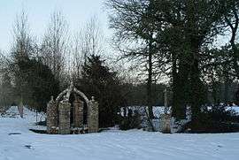 Fountain of St Fiacre | ||
| ||
 Radenac Location within Brittany region  Radenac | ||
| Coordinates: 47°57′49″N 2°42′41″W / 47.9636°N 2.7114°WCoordinates: 47°57′49″N 2°42′41″W / 47.9636°N 2.7114°W | ||
| Country | France | |
| Region | Brittany | |
| Department | Morbihan | |
| Arrondissement | Pontivy | |
| Canton | Grand-Champ | |
| Intercommunality | Pontivy | |
| Government | ||
| • Mayor (2008–2014) | Bernard Le Breton | |
| Area1 | 21.65 km2 (8.36 sq mi) | |
| Population (1999)2 | 825 | |
| • Density | 38/km2 (99/sq mi) | |
| Time zone | UTC+1 (CET) | |
| • Summer (DST) | UTC+2 (CEST) | |
| INSEE/Postal code | 56189 /56500 | |
| Elevation | 72–131 m (236–430 ft) | |
|
1 French Land Register data, which excludes lakes, ponds, glaciers > 1 km2 (0.386 sq mi or 247 acres) and river estuaries. 2 Population without double counting: residents of multiple communes (e.g., students and military personnel) only counted once. | ||
.svg.png)
Radenac (Breton: Radeneg) is a commune in the Morbihan department in Brittany in north-western France.
Geography
The Ével has its source in the commune.
People
Cyclist Jean Robic, who won the Tour de France in 1947, spent his childhood in Radenac, where his father owned the local cycle shop. In honour of his great achievement, the commune renamed the street where his home was after him.
Demographics
Inhabitants of Radenac are called Radenacois.
Twin towns
Radenac is twinned with a small village of Radnage in Buckinghamshire ![]()
Monuments
- The fountain of St Armel (circa 1000)
- The fountain of St Fiacre (17th century)
- The chapelle St Fiacre (construction 1390 to 1514).
See also
References
- Mayors of Morbihan Association (in French)
- INSEE commune file
External links
| Wikimedia Commons has media related to Radenac. |
- French Ministry of Culture list for Radenac (in French)
- Map of Radenac on Michelin (in English)
This article is issued from
Wikipedia.
The text is licensed under Creative Commons - Attribution - Sharealike.
Additional terms may apply for the media files.