Noyal-Pontivy
| Noyal-Pontivy Noal-Pondi | ||
|---|---|---|
| Commune | ||
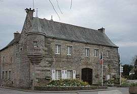 The town hall in Noyal-Pontivy | ||
| ||
 Noyal-Pontivy Location within Brittany region  Noyal-Pontivy | ||
| Coordinates: 48°04′03″N 2°52′51″W / 48.0675°N 2.8808°WCoordinates: 48°04′03″N 2°52′51″W / 48.0675°N 2.8808°W | ||
| Country | France | |
| Region | Brittany | |
| Department | Morbihan | |
| Arrondissement | Pontivy | |
| Canton | Pontivy | |
| Intercommunality | Pontivy Communauté | |
| Government | ||
| • Mayor (2008—2014) | Michel Houdebine | |
| Area1 | 53.45 km2 (20.64 sq mi) | |
| Population (1999)2 | 3,285 | |
| • Density | 61/km2 (160/sq mi) | |
| Time zone | UTC+1 (CET) | |
| • Summer (DST) | UTC+2 (CEST) | |
| INSEE/Postal code | 56151 /56920 | |
| Elevation | 54–162 m (177–531 ft) | |
|
1 French Land Register data, which excludes lakes, ponds, glaciers > 1 km2 (0.386 sq mi or 247 acres) and river estuaries. 2 Population without double counting: residents of multiple communes (e.g., students and military personnel) only counted once. | ||
.svg.png)
Noyal-Pontivy (Breton: Noal-Pondi) is a commune in the Morbihan department of Brittany in north-western France.
Demographics
Inhabitants of Noyal-Pontivy are called in French Noyalais.
Breton language
The municipality launched a linguistic plan through Ya d'ar brezhoneg on 19 September 2005.
See also
- Communes of the Morbihan department
- Gaston-Auguste Schweitzer Sculptor of Noyal-Pontivy war memorial
References
- Mayors of Morbihan Association (in French)
- INSEE commune file
External links
| Wikimedia Commons has media related to Noyal-Pontivy. |
- Official website (in French)
- French Ministry of Culture list for Noyal-Pontivy (in French)
- Map of Noyal-Pontivy on Michelin (in English)
This article is issued from
Wikipedia.
The text is licensed under Creative Commons - Attribution - Sharealike.
Additional terms may apply for the media files.