Bono, Morbihan
| Le Bono Ar Bonoù | |
|---|---|
| Commune | |
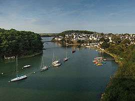 From the bridge "Joseph Le Brix" | |
 Le Bono Location within Brittany region  Le Bono | |
| Coordinates: 47°38′28″N 2°56′58″W / 47.6411°N 2.9494°WCoordinates: 47°38′28″N 2°56′58″W / 47.6411°N 2.9494°W | |
| Country | France |
| Region | Brittany |
| Department | Morbihan |
| Arrondissement | Vannes |
| Canton | Vannes-2 |
| Intercommunality | Golfe du Morbihan - Vannes Agglomération |
| Government | |
| • Mayor (2008–2014) | Bernard Le Scoarnec |
| Area1 | 5.96 km2 (2.30 sq mi) |
| Population (2009)2 | 2,198 |
| • Density | 370/km2 (960/sq mi) |
| Time zone | UTC+1 (CET) |
| • Summer (DST) | UTC+2 (CEST) |
| INSEE/Postal code | 56262 /56400 |
| Elevation | 0–42 m (0–138 ft) |
|
1 French Land Register data, which excludes lakes, ponds, glaciers > 1 km2 (0.386 sq mi or 247 acres) and river estuaries. 2 Population without double counting: residents of multiple communes (e.g., students and military personnel) only counted once. | |
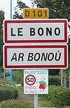
Le Bono (Breton: Ar Bonoù) is a commune in the Morbihan department of Brittany in northwestern France.
According to INSEE, the official name is Bono (without Le),[1] but the town is usually called “Le Bono”;[2] this name is used on the road signs.
Population
Inhabitants of Le Bono are called in French Bonovistes.
Breton language
The municipality launched a linguistic plan through Ya d'ar brezhoneg on November 17, 2008.
See also
References
- ↑ (in French) Le Bono on INSEE
- ↑ (in French) Association des maires du Morbihan Le Bono file
External links
- Official website (in French)
- French Ministry of Culture list for Le Bono (in French)
- Map of Le Bono on Michelin (in English) at Archive.is (archived 2013-05-05)
- Bono on INSEE
| Wikimedia Commons has media related to Bono (Morbihan). |
This article is issued from
Wikipedia.
The text is licensed under Creative Commons - Attribution - Sharealike.
Additional terms may apply for the media files.