Erdeven
| Erdeven An Ardeven | ||
|---|---|---|
| Commune | ||
 The Château of Kéravéon | ||
| ||
 Erdeven Location within Brittany region  Erdeven | ||
| Coordinates: 47°38′N 3°10′W / 47.64°N 3.16°WCoordinates: 47°38′N 3°10′W / 47.64°N 3.16°W | ||
| Country | France | |
| Region | Brittany | |
| Department | Morbihan | |
| Arrondissement | Lorient | |
| Canton | Quiberon | |
| Intercommunality | Ria d'Étel | |
| Government | ||
| • Mayor (2008—2014) | Marie-Françoise Le Jossec | |
| Area1 | 30.64 km2 (11.83 sq mi) | |
| Population (1999)2 | 2,523 | |
| • Density | 82/km2 (210/sq mi) | |
| Time zone | UTC+1 (CET) | |
| • Summer (DST) | UTC+2 (CEST) | |
| INSEE/Postal code | 56054 /56410 | |
| Elevation |
0–36 m (0–118 ft) (avg. 20 m or 66 ft) | |
|
1 French Land Register data, which excludes lakes, ponds, glaciers > 1 km2 (0.386 sq mi or 247 acres) and river estuaries. 2 Population without double counting: residents of multiple communes (e.g., students and military personnel) only counted once. | ||
.svg.png)
Erdeven (An Ardeven in Breton) is a commune in the Morbihan department in the region of Brittany in north-western France.

Kerouriec beach in Erdeven
Its main industry is tourism. Attractions include a seven kilometre-long beach beside the Atlantic and many prehistoric sites featuring megaliths. The Mané-Croch, Mané-Bras and Crucuno dolmens and the Kerzerho alignments lie just outside the commune.
Twin towns
It is twinned with St. Märgen in the Black Forest region of Germany.
Demographics
Inhabitants of Erdeven are called Erdevenois.
See also
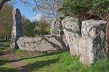
The “Kerzerho Giants” in Erdeven
References
External links
| Wikimedia Commons has media related to Erdeven. |
- Official commune website (in French)
- Cultural Heritage (in French)
- Erdeven on bretagne.com
| Authority control |
|---|
This article is issued from
Wikipedia.
The text is licensed under Creative Commons - Attribution - Sharealike.
Additional terms may apply for the media files.