Locminé
| Locminé Logunec'h | ||
|---|---|---|
| Commune | ||
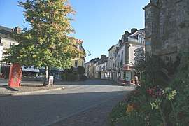 The Place de la République in Locminé | ||
| ||
 Locminé Location within Brittany region  Locminé | ||
| Coordinates: 47°53′15″N 2°50′04″W / 47.8875°N 2.8344°WCoordinates: 47°53′15″N 2°50′04″W / 47.8875°N 2.8344°W | ||
| Country | France | |
| Region | Brittany | |
| Department | Morbihan | |
| Arrondissement | Pontivy | |
| Canton | Grand-Champ | |
| Intercommunality | Centre Morbihan Communauté | |
| Government | ||
| • Mayor (2014—2020) | Grégoire Super | |
| Area1 | 4.86 km2 (1.88 sq mi) | |
| Population (2015)2 | 4,159 | |
| • Density | 860/km2 (2,200/sq mi) | |
| Time zone | UTC+1 (CET) | |
| • Summer (DST) | UTC+2 (CEST) | |
| INSEE/Postal code | 56117 /56500 | |
| Elevation | 69–153 m (226–502 ft) | |
|
1 French Land Register data, which excludes lakes, ponds, glaciers > 1 km2 (0.386 sq mi or 247 acres) and river estuaries. 2 Population without double counting: residents of multiple communes (e.g., students and military personnel) only counted once. | ||
.svg.png)
Locminé (Breton: Logunec'h) is a commune in the Morbihan department of the region of Brittany in north-western France.
Toponymy
The name Locminé comes from the Breton Loc'h menec'h, itself from the Latin Locus monachorum – (sacred) place of the monks – after the monastery established here in 1008. Use of the term loc'h to denote the many small monasteries founded in Brittany between the eleventh and fourteenth centuries was commonplace, and this is the origin of the majority of parish names beginning in Loc-.
Breton language
As of September 2013, 156 children (i.e. 18.5% of all those enrolled) were being educated in the bilingual streams of Locminé's state and Catholic primary schools.[1]
Twin towns
Locminé is twinned with:
See also
References
- Mayors of Morbihan Association (in French)
- INSEE commune file
- ↑ Office Publique de la Langue Bretonne (in French)
External links
| Wikimedia Commons has media related to Locminé. |
- French Ministry of Culture list for Locminé (in French)
- Map of Locminé on Michelin (in English)