Pluneret
| Pluneret Plunered | |
|---|---|
| Commune | |
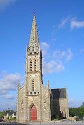 The church in Pluneret | |
 Pluneret Location within Brittany region  Pluneret | |
| Coordinates: 47°40′35″N 2°57′22″W / 47.6764°N 2.9561°WCoordinates: 47°40′35″N 2°57′22″W / 47.6764°N 2.9561°W | |
| Country | France |
| Region | Brittany |
| Department | Morbihan |
| Arrondissement | Lorient |
| Canton | Auray |
| Intercommunality | Pays d'Auray |
| Government | |
| • Mayor (2008—2014) | Jean-Jacques Mérour |
| Area1 | 26.20 km2 (10.12 sq mi) |
| Population (1999)2 | 3,714 |
| • Density | 140/km2 (370/sq mi) |
| Time zone | UTC+1 (CET) |
| • Summer (DST) | UTC+2 (CEST) |
| INSEE/Postal code | 56176 /56400 |
| Elevation | 0–59 m (0–194 ft) |
|
1 French Land Register data, which excludes lakes, ponds, glaciers > 1 km2 (0.386 sq mi or 247 acres) and river estuaries. 2 Population without double counting: residents of multiple communes (e.g., students and military personnel) only counted once. | |
Pluneret (Breton: Plunered) is a commune in the Morbihan department of Brittany in north-western France.
Demographics
Inhabitants of Pluneret are called in French Pluneretains.
Breton language
The municipality launched a linguistic plan through Ya d'ar brezhoneg on July the 13th of 2006.
In 2008, there was 12.89% of the children attended the bilingual schools in primary education.[1]
See also
References
- Mayors of Morbihan Association (in French)
- INSEE commune file
- ↑ (in French) Ofis ar Brezhoneg: Enseignement bilingue
External links
| Wikimedia Commons has media related to Pluneret. |
- Official website (in French)
- French Ministry of Culture list for Pluneret (in French)
- Map of Pluneret on Michelin (in English)
This article is issued from
Wikipedia.
The text is licensed under Creative Commons - Attribution - Sharealike.
Additional terms may apply for the media files.