Bohal
| Bohal | ||
|---|---|---|
| Commune | ||
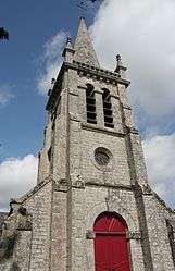 The church of Saint-Gildas, in Bohal | ||
| ||
 Bohal Location within Brittany region  Bohal | ||
| Coordinates: 47°46′56″N 2°26′10″W / 47.7822°N 2.4361°WCoordinates: 47°46′56″N 2°26′10″W / 47.7822°N 2.4361°W | ||
| Country | France | |
| Region | Brittany | |
| Department | Morbihan | |
| Arrondissement | Vannes | |
| Canton | Moréac | |
| Intercommunality | Val d'Oust et de Lanvaux | |
| Government | ||
| • Mayor (2008–2014) | André Piquet | |
| Area1 | 8.45 km2 (3.26 sq mi) | |
| Population (2009)2 | 810 | |
| • Density | 96/km2 (250/sq mi) | |
| Time zone | UTC+1 (CET) | |
| • Summer (DST) | UTC+2 (CEST) | |
| INSEE/Postal code | 56020 /56140 | |
| Elevation | 17–90 m (56–295 ft) | |
|
1 French Land Register data, which excludes lakes, ponds, glaciers > 1 km2 (0.386 sq mi or 247 acres) and river estuaries. 2 Population without double counting: residents of multiple communes (e.g., students and military personnel) only counted once. | ||
.svg.png)
Bohal (Bohal in Breton) is a commune in the Morbihan department of Brittany in northwestern France.
Population
Inhabitants of Bohal are called in French Bohalais.
See also
References
- INSEE statistics
- Mayors of Morbihan Association (in French)
External links
| Wikimedia Commons has media related to Bohal. |
This article is issued from
Wikipedia.
The text is licensed under Creative Commons - Attribution - Sharealike.
Additional terms may apply for the media files.