Saint-Nolff
| Saint-Nolff Sant-Nolf | ||
|---|---|---|
| Commune | ||
 Saint-Mayeul's church in Saint-Nolff | ||
| ||
 Saint-Nolff Location within Brittany region  Saint-Nolff | ||
| Coordinates: 47°42′16″N 2°39′01″W / 47.7044°N 2.6503°WCoordinates: 47°42′16″N 2°39′01″W / 47.7044°N 2.6503°W | ||
| Country | France | |
| Region | Brittany | |
| Department | Morbihan | |
| Arrondissement | Vannes | |
| Canton | Vannes-3 | |
| Intercommunality | Golfe du Morbihan - Vannes Agglomération | |
| Government | ||
| • Mayor (2014-2020) | Nadine Le Goff-Carnec | |
| Area1 | 25.92 km2 (10.01 sq mi) | |
| Population (2007)2 | 3,603 | |
| • Density | 140/km2 (360/sq mi) | |
| Time zone | UTC+1 (CET) | |
| • Summer (DST) | UTC+2 (CEST) | |
| INSEE/Postal code | 56231 /56250 | |
| Elevation | 19–147 m (62–482 ft) | |
|
1 French Land Register data, which excludes lakes, ponds, glaciers > 1 km2 (0.386 sq mi or 247 acres) and river estuaries. 2 Population without double counting: residents of multiple communes (e.g., students and military personnel) only counted once. | ||
Saint-Nolff (Breton: Sant-Nolf) is a commune in the Morbihan department of Brittany in north-western France.
Demographics
Inhabitants of Saint-Nolff are called in French Nolfféens.
Emblazonnement
.svg.png)
Vairé d'or et de sable; au franc-canton de gueules à l'aigle d'argent, becqué, membré et lampassé d'or.
("Colour of gold and yellow; "canton-fair" in red and eagle in white, with gold beak, legs carved and langued in gold")
Twin towns
Saint-Nolff is twinned with:

Buildings
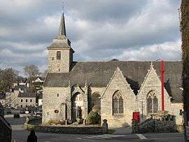
The Saint-Mayeul's church
Saint Mayeul's church
The Saint-Mayeul's church (french name: église Saint-Mayeul) was built in the 16th century.
Castle Kerboulard

Part of castle
See also
References
- Mayors of Morbihan Association (in French)
- INSEE commune file
External links
| Wikimedia Commons has media related to Saint-Nolff. |
- French Ministry of Culture list for Saint-Nolff (in French)
- Map of Saint-Nolff on Michelin (in English)
This article is issued from
Wikipedia.
The text is licensed under Creative Commons - Attribution - Sharealike.
Additional terms may apply for the media files.