Príncipe
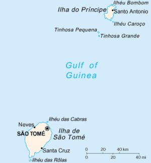 Map of São Tomé and Príncipe with Príncipe near the top | |
| Geography | |
|---|---|
| Location | São Tomé and Príncipe |
| Coordinates | 1°37′N 7°24′E / 1.617°N 7.400°ECoordinates: 1°37′N 7°24′E / 1.617°N 7.400°E |
| Area | 136 km2 (53 sq mi) |
| Highest elevation | 948 m (3,110 ft) |
| Highest point | Pico de Príncipe |
| Administration | |
| Districts | 1 (Pagué) |
| Capital city | Santo António |
| Demographics | |
| Demonym | Príncipean or Principean |
| Population | 6,000 (approx.) |
| Pop. density | 36.8 /km2 (95.3 /sq mi) |
| Area code(s) | 00239-19x-xxxx? |
Príncipe is the smaller, northern major island of the country of São Tomé and Príncipe lying off the west coast of Africa in the Gulf of Guinea.[1] It has an area of 136 square kilometres (53 sq mi) and a population of approximately 5,000. The island is a heavily eroded volcano speculated to be over three million years old, surrounded by smaller islands including Ilheu Bom Bom, Ilhéu Caroço, Tinhosa Grande and Tinhosa Pequena. Part of the Cameroon Line archipelago, Príncipe rises in the south to 948 metres at Pico de Príncipe, in a thickly forested area forming part of the Obo National Park.[2]
History
The island was uninhabited when discovered by the Portuguese on 17 January 1471 and was first named Saint Anthony ("Ilha de Santo Antão").
The first settlement was founded in 1502 and what was the island name would be used for the main town, the island name became "Príncipe" (Prince's island) in honor of Afonso, Prince of Portugal, his father's favorite. Subsequently, the north and centre of the island were made into plantations, most of them formed by Portuguese colonialists using slave labor. These concentrated initially on producing sugar and later on cocoa, becoming the world's greatest cocoa producer.[3] Since independence, these plantations have largely reverted to forest.
In 1573, the donatary was reverted to the Portuguese Crown. Under the context of the Habsburg Philippine Dynasty which ruled all of its empire. The first occupiers of the Island were the Dutch, an expedition sent by the Dutch merchant Balthazar de Moucheron, occupied the island from August to October 1598 and again in 1600, when a second Dutch expedition was sent. That year, to encourage the defense of the island, the island received a charter. That time, several governors and capitains of the island included Vasco de Carvalho de Sousa from 1601 to 1604, Rui de Sousa de Alarcão from 1604 to 1609 and D. Fernando de Noronha in 1609.
After the conquest of Elmina Castle by the Dutch in 1637, under the context of the Portuguese Restoration in 1640, they conquered the archipelago from 1641 to 1644 and conrolled the slave trade until they were expelled by the Portuguese in 1648.
The island's fortress named Fortaleza de Santo António da Ponta da Mina on a point inside Baía de Santo António (Santo António Bay) was built in 1695. In 1706 and in 1709, the city was invaded by the French to avoid the fire in the fort. In 1719, the city of Santo António and its fortress was attacked and destroyed by the Welsh pirate Bartholomew Roberts, nicknamed "John Roberts" and "Black Bart" in revenge of the death of his captain Howell Davis.
In 1753, it became the island that was home to the colonial capital along with the diocese seat, it remained until 1852 when it returned to the island of São Tomé and its city.
In 1758, some Acadians (Francophone Canadians of Acadia, later the Southern Maritimes) were deported into the island after the British conquered that colony.
Several additional species of flowers and plants were described and discovered in the 19th century. John Gerrard Keulemans was the first Dutch ornithologists who visited the island in 1865, he made observations of the bird species including grey parrot Psittacus erythracus.[4]
At the start of the early 20th century, the archipelago including the island was the chief producer of coffee and cocoa.
Príncipe was the site where Einstein's theory of relativity was experimentally corroborated by Arthur Stanley Eddington and his team during the total solar eclipse of May 29, 1919; photographs of the eclipse revealed evidence of the 'bending' of starlight, in accordance with Einstein's predictions.
In the mid to the late 20th century, the population steadily grew large: in 1940, the island's population was 3,124, it was 5,000 before 1980 and reached nearly 6,000 in 2001. Portuguese rule did not end until 1974 when the archipelago became an autonomous province and on July 12, 1975, it was no longer part of Portugal. Not long after independence, 3,000 people of Cape Verdean origin came to the island, some would speak the Cape Verdean creole (mainly Santiago/Badiu form) on the island. On April 29, 1995, the island gained its own administration with an autonomous region forming the Pagué District. In 1988, Ponta da Mina had its own lighthouse. In May 2003, when the last dictatorship took over the nation, Príncipe and the surrounding islands never took part, the autonomy was the sole rule for a couple of days; not long after, Santomean administration returned. The southern portion of the island became a fully protected area, that part was included in the Obo Natural Park in 2006, and in 2012 to the south of the island in underwater areas, the Island of Principe Biosphere Reserve was recognised by UNESCO.
Administration
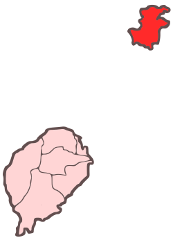
The island is part of Pagué District, the only district of Príncipe Province.
Settlements
Príncipe has one town, Santo António, and an airport (IATA code: PCP, ICAO: FPPR), as well as some villages including Bela Vista, Bombom, Futuro, Neves Ferreira, Paciência, Ponta Fonte, Ribeira Ize, Santo António de Ureca and Vila Rosa. Few of them are connected to the small road network.
Demographics
Portuguese is the official and main language of the island. Portuguese creoles are also spoken: Principense or Lunguyê and, in some scale, Forro are also spoken.
Nature
 Praia do Boi, in Príncipe
 Praia das Bananas, São Tomé and Príncipe
 Carambola in Príncipe
 Lagoa do Caixão, Príncipe Island
 Beach in Príncipe
.jpg) Igreja de Nossa Senhora da Conceição, in Santo António, São Tomé and Príncipe.
Igreja de Nossa Senhora da Conceição, in Santo António, São Tomé and Príncipe.
Príncipe has been entirely forested, the southern portion, the most mountains part remains heavily forested. Abundant flora and fauna are founded. Examples included birds such as the Príncipe kingfisher, Principe seedeater, Principe starling, Príncipe sunbird, black-capped speirops (Zosterops lugubris), Dohrn's thrush-babbler, the Príncipe weaver and the Príncipe white-eye, geckos include the Príncipe gecko (Hemidactylus principensis), frogs include the palm forest tree frog and the Phrynobatrachus dispar. Marine fauna dominate the shores including Muricopsis principensis, a mollusc and the West African mud turtle.
Ecological reserve
UNESCO established the Island of Príncipe Biosphere Reserve in 2012 under the Man and the Biosphere Programme. The reserve encompasses the entire emerged area of the island of Príncipe, and its islets Bom Bom, Boné do Jóquei, Mosteiros, Santana, and Pedra da Galei, and the Tinhosas islands.[5]
Notable people
- Damião Vaz d'Almeida, former Prime Minister of São Tomé and Príncipe
- João Cassandrá, former autonomous president of the island
- João Paulo Cassandra, former autonomous president of the island
- José Cassandra, current president of the island
- Sara Pinto Coelho, colonial born Portuguese writer
- Camilo Domingos, singer
- Mário Domingues, writer, journalist and historian
- Manuela Margarido, writer
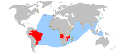
Twin towns – sister cities
Príncipe is twinned with:
References
- ↑ "Satellite View and Map of São Tomé and Príncipe" Nations Online. Retrieved 2014-9-26.
- ↑ "Príncipe: a haven on earth" Financial Times. Retrieved 2014-9-26.
- ↑ Pinnock, D & Pinnock, G (2012) Chocolate Island. Africa Geographic. February 2012
- ↑ Keulemans 1873 - Onze vogels in huis en tuin (vol. 2, p. 3), at the Dutch language Wikisource
- ↑ "World Network of Biosphere Reserves". Island of Príncipe. UNESCO. Retrieved 1 June 2016.
- ↑ "Geminações de Cidades e Vilas". Associação Nacional de Municípios Portugueses (in Portuguese). Retrieved 2013-07-20.
External links
- Map of Príncipe
- Bom Bom Island resort (Príncipe)
- Principe portal


- Príncipe at Curlie (based on DMOZ)
Autonomous Region of Príncipe/Pagué District | ||
|---|---|---|
| Communities |
|  |
| Geographical features | ||
| Buildings | ||
| Football | ||
| Major islands | |
|---|---|
| Minor islands and islets | |
| São Tomé Island | ||
|---|---|---|
| Autonomous Region of Príncipe |
| |
|  | |||||||||||||||||||||||||||||||||||||||||||||||||||||||||||||||||||||||
|
| ||||||||||||||||||||||||||||||||||||||||||||||||||||||||||||||||||||||||
| ||||||||||||||||||||||||||||||||||||||||||||||||||||||||||||||||||||||||
| ||||||||||||||||||||||||||||||||||||||||||||||||||||||||||||||||||||||||
| ||||||||||||||||||||||||||||||||||||||||||||||||||||||||||||||||||||||||
| ||||||||||||||||||||||||||||||||||||||||||||||||||||||||||||||||||||||||