Lobata District
| Lobata | |
|---|---|
| District | |
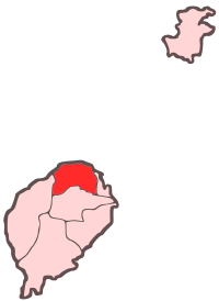 Location within São Tomé and Príncipe | |
| Coordinates: 0°22′N 6°40′E / 0.367°N 6.667°ECoordinates: 0°22′N 6°40′E / 0.367°N 6.667°E | |
| Country | São Tomé and Príncipe |
| Province/Island | São Tomé |
| Seat | Guadalupe |
| Area | |
| • Total | 105 km2 (41 sq mi) |
| Population (2012) | |
| • Total | 20,007 |
| • Density | 190/km2 (490/sq mi) |
| Time zone | UTC+0 (UTC) |
Lobata is a district of São Tomé Province. Out of the seven districts that make up the equatorial Atlantic islands of São Tomé and Príncipe, it is third largest in terms of population and covers approximately 105 square kilometers. Its population is 20,007 (2012).[1] The district capital is Guadalupe. The municipality includes an islet called the Ilhéu das Cabras. The entire district except for the west is becoming a part of the São Tomé City Metro Area.
Population
- 1940: 9,240 (15.2% of the national population)
- 1950: 8,190 (13.6% of the national population)
- 1960: 7,875 (12.3% of the national population)
- 1970: 9,361 (12.7% of the national population)
- 1981: 11,776 (12.2% of the national population)
- 1991: 14,173 (12.1% of the national population)
- 2001: 15,187 (11.0% of the national population)[1]
- 2008: 17,311 (est.)[1]
- 2012: 20,007[1]
Administration
The district are divided into four subdistricts or municipalities and are Conde, Guadelupe, Micoló, and Santo Amaro.
Settlements
Main settlements and communities
The main settlement is the town Guadalupe. Other settlements are:
Hamlets, fractions and other settlements
- Aguã Telha
- Agua Casada
- Aguã Coimbra
- Aguã Sampaio
- Aragão
- Caldeiras
- Canavial
- Cruz Grande
- Desejada
- Fernão Dias
- Gratidão
- Guarda
- Guegue (Praia das Conchas - South)
- Laranjeiras
- Mesquita
- Monte Carmo
- Morro Peixe
- Morro Vigia
- Nova Sintra (Nova Cintra)
- Poisco Alto
- Rio Vouga
- Saltado
- Santarém Castanhede
- Santa Clara
- Santa Luzia
- Santa Luzia de Lobata
- Santa Maria
- São Carlos
- Uba Cabra - name of Angolan origin
- Vale Flor
- Vale Prazeres
- Vila Braga
- Vila Graciosa
Geography
Numerous beaches by the coast include Praias de Lagoa Azul, das Conchas, Guegue Micoló, das Plancas and dos Tamarindos. Like the whole island, its geography consisted nothing but primary forests without any meadows or meads before the first settlers (including slaves) came. Tropical plantations notably cocoa and coffee and rarely bananas. In the east is an increasing growing urban area. Lagoa Azul, a lagoon is located in the west of the district.
Landmarks
- Lagoa Azul Lighthouse - west of Morro Peixe
Politics
Lobata currently has six seats in the National Assembly.[2]
Points of interests
- Roça Boa Entrada
- Roça do Rio Ouro - a warehouse now served as a hotel - located in Agostinho Neto
Notable people
- William Barbosa, footballer
- Olinda Beja, writer
- Aurélio Martins, journalist, businessman and politician
- Ludgério Silva, footballer
Sports
Notable football (soccer) clubs of the district include Desportivo de Guadalupe, UD Correia and Kê Morabeza, a club once known as Bela Vista.
Twin towns
References
External links

Places adjacent to Lobata District | ||||||||||
|---|---|---|---|---|---|---|---|---|---|---|
| ||||||||||
| Communities | | |
|---|---|---|
| Geography | ||
| Landmarks | ||
| Culture | ||
| São Tomé Island | ||
|---|---|---|
| Autonomous Region of Príncipe |
| |