Ilhéu das Cabras
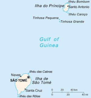 Map of São Tomé and Príncipe with Ilhéu das Cabras north of the island of São Tomé | |
| Geography | |
|---|---|
| Location | north of São Tomé near the urban area of São Tomé, São Tomé and Príncipe |
| Coordinates | 0°24′29″N 6°42′54″E / 0.408°N 6.715°ECoordinates: 0°24′29″N 6°42′54″E / 0.408°N 6.715°E |
| Administration | |
| Demographics | |
| Population | 0 |
| Additional information | |
| Stratovolcano | |
Ilhéu das Cabras is an island in the Gulf of Guinea. It is one of the smaller islands of São Tomé and Príncipe. The islet is located near the north coast of the island of São Tomé, 8 km north of the city of São Tomé.
Description

.
.jpg)
The islet has two small hills, one in the southwest and one in the northeast, the northeast one has the highest point. The islet is generally almost entirely forested, barren parts also dominate especially the eastern part.
Almost in the middle of islet at the second hill has a small lighthouse, it may be the first built in the nation, built in the Portuguese Colonial era. Its focal height is 98 meters which is one of the highest and its range is 20 km (12 nmi).[1]
Surrounding the islet to the northwest and parts of the southeast is a light blue area where the waters are shallow, within the bay, the waters are not shallow. It is also the shallowest area of water being the second largest that surround the island and in the nation.
The islet can be seen from parts of the northeast of the island as well as from the city of São Tomé in the south of Ana Chaves Bay especially from Avenida Marginal 12 de Julho.
History
During the Ice Age when the sea level was 130 meters lower than the present day, it formed a part of the island of São Tomé and were two hills, thousands of years ago, the hill separated from the island and became a current islet.
As with the island, the islet was discovered by Portuguese explorers João de Santarém and Pêro Escobar between 1469 and 1471 on Saint Thomas' feast day.
The islet were mentioned in the 1616 map by Jodocus Hondius[2] Later maps mentioned that was thought to be in the Southern Hemisphere and as "Morro Caebres" in the 1665 map by Johannes Vingboons.[3]and the 1780 map by A. Dalrymple.[4] From the 19th century, it would be fully mapped as in the Northern Hemisphere.
Nature
Flora and fauna dominates the island. The island has fauna including birds and some other animals as the islet was once part of the nearby island in the Late Ice Age. Also marine fauna such as fishes surrounds the islet, one of them founded in the islet is the sea snail, the rock snail species Muricopsis hernandezi. Other sea snails and molluscs (mollusks) including sea slugs are also founded.
References
- ↑ "Sao Tome & Principe". ARLHS World of Lights (WLOL). Amateur Radio Lighthouse Society. April 8, 2009. Retrieved 4 May 2017.
- ↑ 1616 map of the island of Saint Thomas (now São Tomé) by Jodocus Hondius, now at the French National Library
- ↑ 1665 map of the island of Saint Thomas (now São Tomé) by Johannes Vingboons, now at the Dutch National Archive
- ↑ 1780 map of the island of Saint Thomas (now São Thomé) by T. Harmar and A. Dalrymple, now at the French National Library
External links

| Major islands | |
|---|---|
| Minor islands and islets | |
| Communities | 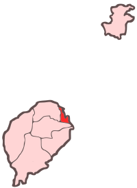 | |
|---|---|---|
| Geographical features |
| |
| Universities and educational institutions | ||
| Landmarks and tourism | ||
| Sports facilities and complexes |
| |
| Transportation |
| |
| Culture | ||
| Topics | ||
| Media |
| |