Tinhosa Pequena
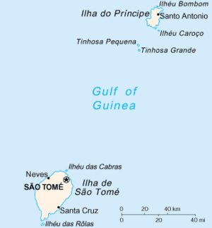 Map of São Tomé and Príncipe with Tinhosa Pequena on the top | |
| Geography | |
|---|---|
| Location | São Tomé and Príncipe, northeast of the island of São Tomé Island and about 20 km (12 mi) SW of Príncipe Island |
| Coordinates | 1°24′26″N 7°16′25″E / 1.4071°N 7.2736°ECoordinates: 1°24′26″N 7°16′25″E / 1.4071°N 7.2736°E |
| Area | 1 km2 (0.39 sq mi) (approx.) |
| Highest elevation | 75 m (246 ft) (approx. 50 to 100 m) |
| Administration | |
| Demographics | |
| Population | 0 |
| Pop. density | 0 /km2 (0 /sq mi) |
| Additional information | |
| Stratovolcano | |
Tinhosa Pequena is an islet in São Tomé and Príncipe located northeast of the main island of São Tomé and approximately 20 km (12 mi) southwest of the island of Príncipe. The islet is north of the nearby larger islet named Tinhosa Grande.
Since 2012, it forms a part of the UNESCO's Island of Príncipe Biosphere Reserve (also known as Príncipe Biosphere Reserve as it encompass its surrounding islands).[1]
Numerous seabirds dominate the islet including brown noddy (Anous stolidus), Anous minutus, Onychoprion fuscatus, white-tailed tropic bird (Phaethon lepturus) and the brown booby (Sula leucogaster)[2] These are also founded on the neighboring islet.
Geography
The islet contains dry grasslands and rock ledges that elevate up to 40 m (130 ft).
Panorama
The islet can be seen clearly from the southwestern part of Príncipe Island and, more rarely, from São Tomé Island.
Nearest islands and islets
- Príncipe, approximately 20 km (12 mi) northeast
- Tinhosa Grande, south
- São Tomé, approximately 100 km (62 mi) southwest
References
- ↑ "World Network of Biosphere Reserves". Island of Príncipe. UNESCO. Retrieved 1 June 2016.
- ↑ Christy, Patrice (17 March 2011). "Important Bird Areas in Africa and associated islands" (PDF). pp. 727–731. Retrieved 17 March 2011.
Autonomous Region of Príncipe/Pagué District | ||
|---|---|---|
| Communities |
|  |
| Geographical features | ||
| Buildings | ||
| Football | ||
| Major islands | |
|---|---|
| Minor islands and islets | |