Ilhéu Bom Bom
 Map of São Tomé and Príncipe Ilhéu Bombom with on the top | |
| Geography | |
|---|---|
| Location | São Tomé and Príncipe |
| Coordinates | 1°41′56″N 7°24′09″E / 1.698855°N 7.402632°ECoordinates: 1°41′56″N 7°24′09″E / 1.698855°N 7.402632°E |
| Administration | |
| Demographics | |
| Population | 15 (2008) |
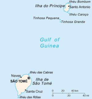
Ilhéu Bom Bom, also written as Ilhéu Bombom, is an island in the Gulf of Guinea. The islet is located north of the coast of the island of Príncipe, one of the main islands of São Tomé and Príncipe and is almost completely forested. The islet does not have the northernmost point in São Tomé and Príncipe it is second behind Pedra da Galé further north. Its population is 15 (2008 est.).[1] The island includes a couple of tourist resorts in São Tomé and Príncipe.

On the island has its own lighthouse built at the end of the 20th century in 1997, its focal height is 64 meters making it second and its range extends up to 20 km (12 nmi) for the white light while the green light extends up to 17 km (9 nmi).[2]
Since 2012, it forms a part of the UNESCO's Island of Príncipe Biosphere Reserve (also known as Príncipe Biosphere Reserve as it encompass its surrounding islands).[3]
References
- ↑ INE, Evolução da população São-Tomense por localidades, 2001/2007-08
- ↑ "Sao Tome & Principe". ARLHS World of Lights (WLOL). Amateur Radio Lighthouse Society. April 8, 2009. Retrieved 4 May 2017.
- ↑ "World Network of Biosphere Reserves". Island of Príncipe. UNESCO. Retrieved 1 June 2016.
External links

Pagué District/Autonomous Region of Príncipe | ||
|---|---|---|
| Communities | 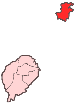 | |
| Geographical features | ||
| Buildings | ||
| Football | ||
| Major islands | |
|---|---|
| Minor islands and islets | |