Malindi
| Malindi | |
|---|---|
| Municipality | |
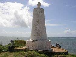 Pillar of Vasco da Gama | |
 Malindi Location in Kenya | |
| Coordinates: 3°13′25″S 40°7′48″E / 3.22361°S 40.13000°ECoordinates: 3°13′25″S 40°7′48″E / 3.22361°S 40.13000°E | |
| Country |
|
| County | Kilifi County |
| Founded | 13th – 14th Century |
| Re-settled | 1861 |
| Population (2009) | |
| • Total | 207,253[1] |
| Time zone | UTC+3 (EAT) |
Malindi (known as Melinde in antiquity) is a town on Malindi Bay at the mouth of the Galana River, lying on the Indian Ocean coast of Kenya. It is 120 kilometres northeast of Mombasa. The population of Malindi was 207,253 as of the 2009 census.[1] It is the largest urban centre in Kilifi County.
Overview
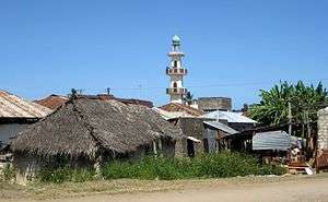
Tourism is the major industry in Malindi. The city is popular among Italian tourists. Malindi is served with a domestic airport and a highway between Mombasa and Lamu. The nearby Watamu resort and Gedi Ruins (also known as Gede) are south of Malindi. The mouth of the Sabaki River lies in northern Malindi. The Watamu and Malindi Marine National Parks form a continuous protected coastal area south of Malindi. The area shows classic examples of Swahili architecture. The majority of Malindi's population is Muslim.[2]
Malindi is home to the Malindi Airport and Broglio Space Centre.
History
The first written reference to the present day Malindi likely comes from Abu al-Fida (1273–1331), a Kurdish geographer and historian. He wrote that Malindi is situated to the south of the mouth of the river, which begins in the Mountain of Comr hundreds of kilometres away. This mountain may be Mount Kenya, where Galana River originates. Therefore, Malindi has existed as a Swahili settlement since at least the 13th century.[3]
.png)
Once rivalled only by Mombasa for dominance in this part of East Africa, Malindi has traditionally been a port city. In 1414, the town was visited by the fleet of the Chinese explorer Zheng He. Malindi's ruler sent a personal envoy with a giraffe as a present to China on that fleet.[3]
The Portuguese explorer Vasco da Gama met Malindi authorities in 1498 to sign a trade agreement and hire a guide for the voyage to India, when he erected a coral pillar. Vasco da Gama was given a warm reception from the Shiek of Malindi, which contrasted with the hostile reception he encountered in Mombasa.[3] The pillar stands to this day, though there have been calls by conservationists to take care of it, since soil erosion might make the pillar fall into the ocean. It is a fairly popular tourist attraction for both local and international tourists.
In 1498 Malindi was a prosperous town with a population of about 6,000. The African Arabs were the ruling class with many Swahili Africans as well as Indian traders living in the town. The main source of prosperity was the export of ivory and rhino horns as well as exporting agricultural products such as coconuts, oranges, millet and rice.[3] In 1499 the Portuguese established a trading post in Malindi that served as a rest stop on the way to and from India. In 1509 the Portuguese established a factory (custom house) in Malindi, which they abandoned in 1512. Malindi remained the centre of Portuguese activity in eastern Africa until 1593 when the Portuguese moved their main base to Mombasa. After that the town gradually declined until it almost disappeared by the end of 17th century. In 1845 Ludwig Krapf visited the town and found it overgrown by vegetation and uninhabited.[3]
A Portuguese chapel with a graveyard was built before 1542 when Francis Xavier visited the town.[3] Many buildings of Swahili architecture survive, including the Juma Mosque and palace on the beach.
Malindi was conquered by Sultan Majid of Zanzibar in 1861 and until the end of 19th century served as a center of the slave trade. In 1890 Malindi came under British administration. The British abolished both the slave trade and slavery. This act led to a significant decline in agricultural production. Outside agriculture there were few industries in Malindi at the beginning of the 20th century; among them were making mats and bags, crushing sesame seeds for oil and producing a Swahili drink called tembo. Malindi was officially made a town in 1903. Ten years later its population stood at around 1148 and included eight Europeans, 67 Asians, 230 Arabs and 843 Africans.[3]
Malindi experienced a trade boom between the end of the World War I and 1925, when a famine occurred. Exports to foreign ports grew to £26,000 by 1924. Europeans started to return to Malindi in the 1930s, buying land from Arabs. Some of them like Commander Lawford opened the first hotels, which became the foundation of the future tourist industry. During World War II Malindi was one of only two towns in East Africa bombed by the Italians. This happened on 24 October 1940, and after this event allied troops were stationed in the town until the end of the war. After the World War II Malindi began developing into a resort.[3]
Climate
| Climate data for Malindi (extremes 1892–present) | |||||||||||||
|---|---|---|---|---|---|---|---|---|---|---|---|---|---|
| Month | Jan | Feb | Mar | Apr | May | Jun | Jul | Aug | Sep | Oct | Nov | Dec | Year |
| Record high °C (°F) | 34.0 (93.2) |
34.0 (93.2) |
34.5 (94.1) |
39.0 (102.2) |
32.2 (90) |
30.5 (86.9) |
30.8 (87.4) |
29.8 (85.6) |
32.0 (89.6) |
32.0 (89.6) |
34.1 (93.4) |
33.0 (91.4) |
39.0 (102.2) |
| Average high °C (°F) | 30.8 (87.4) |
30.9 (87.6) |
31.8 (89.2) |
31.1 (88) |
28.8 (83.8) |
27.9 (82.2) |
27.3 (81.1) |
27.4 (81.3) |
28.3 (82.9) |
29.6 (85.3) |
30.5 (86.9) |
30.8 (87.4) |
29.6 (85.3) |
| Average low °C (°F) | 23.3 (73.9) |
23.5 (74.3) |
23.9 (75) |
24.2 (75.6) |
23.4 (74.1) |
22.6 (72.7) |
22.0 (71.6) |
21.6 (70.9) |
21.7 (71.1) |
22.2 (72) |
22.8 (73) |
23.4 (74.1) |
22.9 (73.2) |
| Record low °C (°F) | 20.0 (68) |
19.6 (67.3) |
21.0 (69.8) |
20.8 (69.4) |
21.0 (69.8) |
19.5 (67.1) |
18.6 (65.5) |
17.0 (62.6) |
17.2 (63) |
19.0 (66.2) |
19.0 (66.2) |
21.0 (69.8) |
17.0 (62.6) |
| Average precipitation mm (inches) | 11 (0.43) |
17 (0.67) |
36 (1.42) |
163 (6.42) |
298 (11.73) |
154 (6.06) |
91 (3.58) |
64 (2.52) |
47 (1.85) |
68 (2.68) |
75 (2.95) |
35 (1.38) |
1,059 (41.69) |
| Average precipitation days | 2 | 2 | 3 | 11 | 17 | 12 | 12 | 9 | 7 | 6 | 6 | 3 | 90 |
| Source #1: World Meteorological Organization[4] | |||||||||||||
| Source #2: Meteo Climat (record highs and lows)[5] | |||||||||||||
Local governance
Malindi now falls under Kilifi County as per the administrative changes in the new constitution passed in August 2010. Malindi forms a municipal council with the following thirteen wards: Barani, Ganda/Mkaumoto, Gede, Gede North, Gede South, Kijiwetanga, Madunguni, Malimo, Malindi Central, Malindi North, Maweni, Shella, Watamu Town. All of them are located within Malindi Constituency.[6]
Gallery
 Close to Robinson Island Kenya north of Malindi
 Sunrise over the Indian Ocean at Malindi
 Beach close to Malindi
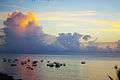 Sunset with boats in Malindi
References
- 1 2 "2009 Census Vol 1 Table 3 Rural and Urban Population – Open Data Portal". Archived from the original on 29 July 2016. Retrieved 11 November 2016.
- ↑ Oded, Arye (2000). Islam and Politics in Kenya. Lynne Rienner Publishers, p. 11
- 1 2 3 4 5 6 7 8 Martin, Esmond Bradley (2009) [originally published in 1970]. Malindi. Past and Present (New ed.). The National Museum of Kenya.
- ↑ "World Weather Information Service – Malindi". World Meteorological Organization. Retrieved 31 August 2016.
- ↑ "Station Malindi" (in French). Meteo Climat. Retrieved 31 August 2016.
- ↑ Polling Centres in Kenya Archived 28 June 2007 at the Wayback Machine.. Electoral Commission of Kenya.
External links
| Wikimedia Commons has media related to Malindi. |
| Wikivoyage has a travel guide for Malindi. |
|  | |||||||||||||||||||||||||||||||||||||||||||||||||||||||||||||||||||||||
|
| ||||||||||||||||||||||||||||||||||||||||||||||||||||||||||||||||||||||||
| ||||||||||||||||||||||||||||||||||||||||||||||||||||||||||||||||||||||||
| ||||||||||||||||||||||||||||||||||||||||||||||||||||||||||||||||||||||||
| ||||||||||||||||||||||||||||||||||||||||||||||||||||||||||||||||||||||||
| ||||||||||||||||||||||||||||||||||||||||||||||||||||||||||||||||||||||||
{{
| Authority control |
|---|