Parque Natural Obô de São Tomé
| Obo Natural Park | |
|---|---|
 | |
| Area | 290 km² |
| Created | 2006 |
Obo Natural Park or Ôbo Natural Park (Portuguese: Parque Natural Ôbo) is a natural park of São Tomé and Príncipe, covering some 235 km² (30% of the island) of São Tomé Island in its south and 65 km² of Príncipe Island.[1] Despite its name, it has the category of national park of the IUCN.[2] On the larger island, it covers the districts of Me-Zochi, most of Lemba and the much of Caué The name etymology is of Angolan origin.
Logo
Its park logo has a green seal with the park name Obô it and has a blue label on the bottom reading Natural Park, in Portuguese: Parque Natural.
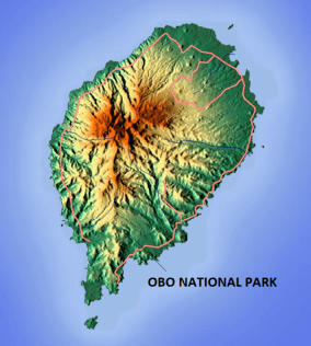
Geography
.jpg)
The natural park was established in 2006 and is the country's only protected area at the national level. Now there is another protected area created in 2012 and is the Island of Príncipe Biosphere Reserve and is at the international level.
Pico Cão Grande is located in the southern-central part of the park on the island of Sao Tomé and rises dramatically in a needle-like shape over 300 metres (980 ft) above the surrounding terrain and the summit is 663 metres (2,175 ft) above sea level.[3]
.jpg)
Several places inside the park includes Bombaim which is next to the nation's tallest summit, Bom Successo, the area north of Porto Alegre and São Miguel in the west.
The park is known internationally amongst conservationists for its biologically rich dense virgin rainforests. It is also characterized by a wide range of biotopes, from lowland and mountain forests, to mangroves and savanna area, which contribute to its unique ecosystem. The park includes virgin Atlantic high altitude rainforest and secondary rainforest (known to locals as capoeira) which contains abandoned plantations.[1]
In 1988, scientists classified the forests of São Tomé and Príncipe as the second most important in terms of biological interest out of 75 forests of Africa; most of the species found in the islands are found in the national park.[1] The WWF has listed the forests of the national park as among the Global 200, the 200 most important biological areas on the planet and the forest of Obo is listed as an Important Bird Area (IBA) of Africa.[1]
The average annual rainfall is 2,493 millimetres (98.1 in). The park's altitude ranges between 0–1,973 metres (0–6,473 ft).[4]
Flora and fauna
Flora includes the evergreen coniferous Afrocarpus mannii. Orchards, ferns and mosses are common in the area. Several mangrove plants includes Avicennia germinans, Green mangrove and the Golden leather fern (Acrostichum aureum). The rainforests contain 100 unique orchids,[5] and over 700 species of flora.[6]
The park's fauna includes the African manatee, as well as Newton's grassland frog, Sao Tomé giant treefrog, São Tomé Caecilian, Moller's gulf frog, and Peters' river frog.[4] Birds include the São Toméan grosbeak (Crithagra concolor), São Toméan ibis (Bostrychia bocagei), São Toméan shorttail (Amaurocichlia bocagei), the Giant sunbird (Dreptes thomensis), São Tomé fiscal (Lanius newtoni), São Tomé oriole (Oriolus crassirostris) and São Tomé thrush (Turdus olivaceofuscus). Bats include the São Tomé leaf-nosed bat (Hipposideros thomensis). Turtles include the Leatherback sea turtle. There are also some species of snakes being the few islands distant from the West African shore to have snakes especially venomous types. Invertebrates including ome moths include Theretra viridis, Hyalobathra barnsalis and Pseudoclanis tomensis and an ant species Tetramorium renae.
On Príncipe island, they include a frog known as Phrynobatrachus dispar, birds such as Dohrn's thrush-babbler (Horizorhinus dohrni), the Príncipe kingfisher, Principe starling and the Príncipe thrush (Turdus xanthorhynchus), and the grey parrot (Psittacus erithacus), and a moth such as Agrotera albalis.
References
- 1 2 3 4 "Conservation history". Obo Park.com. Retrieved 10 November 2011.
- ↑ "Ôbo (São Tomé e Príncipe) - Area report". Retrieved 16 June 2013.
- ↑ United States. Naval Oceanographic Office (1969). Sailing directions for the southwest coast of Africa, from Cape Palmas to Cape of Good Hope. Retrieved 10 November 2011.
- 1 2 "Overview of Obo". European Commission Joint Research Centre. Oct 28, 2010. Retrieved 15 November 2011.
- ↑ "Tourist Attractions". Sao Tome and Principe Travel and Tourism. Retrieved 15 November 2011.
- ↑ Ham, Anthony (30 July 2010). Lonely Planet Africa. Lonely Planet. pp. 624–. ISBN 978-1-74104-988-6. Retrieved 15 November 2011.
External links
| Wikimedia Commons has media related to Parque Natural Obô de São Tomé. |