Sohar
| Suhar (Sohar) صُحَار | |
|---|---|
| City | |
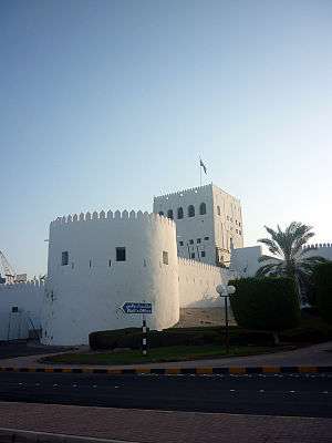 The fort at Al Hujra. | |
 Suhar (Sohar) Location in Oman | |
| Coordinates: 24°20′31.2″N 56°43′47.6″E / 24.342000°N 56.729889°E | |
| Country |
|
| Governorate | Al Batinah North |
| Elevation | 4 m (13 ft) |
| Population (2016) | |
| • Total | 221,605 |
| Time zone | UTC+4 (Oman Standard Time) |
Suhar (Sohar) (Arabic: صُحَار, also Romanized as Suḥār) is the capital and largest city of the Al Batinah North Governorate in Oman. An ancient capital of the country that once served as an important Islamic port town,[1] Suhar has also been credited as the mythical birthplace of Sinbad the Sailor.[2]
According to the 2010 census, Suhar's population was 140,006, making it Oman's fifth most-populated settlement.[3] Described as an industrial town,[4] the development of the Sohar Industrial Port during the 2000s has transformed it into a major Omani industrial hub.
History
As the largest town in the region, it has been argued that Suhar is identified with the ancient town called Omana (Arabic: عُمَانَة) mentioned by Pliny the Elder in his Natural History. This settlement is believed to have given Oman its name.[5]
Industry
Suhar is currently experiencing significant investment and economic shifts making it the focus of attention of many local and international investors and businessmen. This change is due to a series of investment projects and economic giant in Suhar industrial area where Port of Sohar is located. Established in 2002, the port has a strategic importance due to its nearness to the Strait of Hormuz. It is operated by Suhar Industrial Port Company (SIPC) and it is considered a world class port. With current investments exceeding $12 billion, it is one of the world’s largest port development projects.
The Omani government has paid special attention to the city of Suhar, and placed it in the priorities of the future plan of the Omani economy in 2020. The goal of the Omani government is to make Suhar a business and industrial hub and help the Omani economy diversify away from oil. In order for the Omani economy to achieve this economic diversification, the Omani government is investing in a number of projects in the industrial area of Suhar. For example, it is investing more than $5 billion in the steel industry in which Oman aims to be one of the Gulf Cooperation Council's leading producers. In addition to the steel industry, there is also the industry of aluminium in Suhar industrial area. Sohar Aluminium Company was established in 2004[6] and it is considered one of the leading projects that play a major role in the sultanate’s economic diversification strategy.
Education
Suhar has four high educational institutes:
- Sohar University – a private university in association with the University of Queensland.
- Sohar College of Applied Sciences – a government owned college.
- Oman Medical College – a private university in association with West Virginia University School of Medicine.
- International Maritime College Oman
Suhar also has a number of international schools such as:
- Al Batinah International School (owned by Sohar Aluminium & ORPIC) – only IB SCHOOL http://abisoman.com/
- Sohar International School(S.I.S)
- Indian School Sohar
- Pakistan School Sohar
Climate
Suhar has a hot desert climate (Köppen climate classification BWh) with very hot summers and mild winters. Precipitation is low; more than half of the year's total rainfall falls in February, and summers are almost completely dry.
| Climate data for Sohar | |||||||||||||
|---|---|---|---|---|---|---|---|---|---|---|---|---|---|
| Month | Jan | Feb | Mar | Apr | May | Jun | Jul | Aug | Sep | Oct | Nov | Dec | Year |
| Record high °C (°F) | 32.6 (90.7) |
32.1 (89.8) |
37.4 (99.3) |
44.5 (112.1) |
46.9 (116.4) |
48.5 (119.3) |
50.0 (122) |
45.0 (113) |
43.2 (109.8) |
42.4 (108.3) |
37.7 (99.9) |
33.9 (93) |
50 (122) |
| Average high °C (°F) | 24.2 (75.6) |
25.3 (77.5) |
27.5 (81.5) |
31.9 (89.4) |
36.3 (97.3) |
36.9 (98.4) |
36.2 (97.2) |
34.7 (94.5) |
34.1 (93.4) |
33.0 (91.4) |
29.5 (85.1) |
26.1 (79) |
31.3 (88.4) |
| Daily mean °C (°F) | 18.9 (66) |
19.5 (67.1) |
22.4 (72.3) |
26.8 (80.2) |
31.0 (87.8) |
32.7 (90.9) |
33.0 (91.4) |
31.6 (88.9) |
30.3 (86.5) |
27.4 (81.3) |
23.7 (74.7) |
20.4 (68.7) |
26.5 (79.6) |
| Average low °C (°F) | 12.4 (54.3) |
13.3 (55.9) |
16.1 (61) |
19.6 (67.3) |
23.7 (74.7) |
26.2 (79.2) |
28.2 (82.8) |
27.1 (80.8) |
24.7 (76.5) |
20.4 (68.7) |
16.8 (62.2) |
14.4 (57.9) |
20.2 (68.4) |
| Record low °C (°F) | 5.7 (42.3) |
5.8 (42.4) |
6.8 (44.2) |
11.2 (52.2) |
16.0 (60.8) |
19.7 (67.5) |
22.4 (72.3) |
21.4 (70.5) |
17.4 (63.3) |
12.0 (53.6) |
8.0 (46.4) |
7.4 (45.3) |
5.7 (42.3) |
| Average precipitation mm (inches) | 4.7 (0.185) |
56.2 (2.213) |
17.0 (0.669) |
7.8 (0.307) |
2.5 (0.098) |
0.0 (0) |
0.1 (0.004) |
0.0 (0) |
0.5 (0.02) |
0.0 (0) |
3.8 (0.15) |
15.9 (0.626) |
108.5 (4.272) |
| Average relative humidity (%) | 72 | 74 | 72 | 65 | 63 | 70 | 77 | 80 | 79 | 73 | 72 | 74 | 73 |
| Mean monthly sunshine hours | 269.4 | 228.6 | 230.8 | 276.0 | 322.4 | 310.9 | 281.5 | 275.6 | 276.3 | 284.6 | 257.5 | 259.8 | 3,273.4 |
| Source #1: NOAA (all but average maximum, 1980–1990) [7] | |||||||||||||
| Source #2: www.world-climates.com (average maximum) [8] | |||||||||||||
Parks
Suhar has four main parks. The first is Suhar Park, located in Al Humbar. The second is the Silver Jubilee Park which is located in Sallan. The third is the Entertainment Park in Sanaiyyah.The fourth is in falaj alqabail. And it has many other parks like Alminyal, Alsanqar, Alsuwaihra, Al-ons, Corniche park and Aluwaynat park.
Sports and leisure
The city has the Sohar Regional Sports Complex and the Suhar Plaza- City Cinema.
Landmarks
- Globe Roundabout
- Sultan Qaboos Mosque Suhar
- Suhar Gate
- Bahjat Al Anthar (The Sultan's Palace in Suhar)
- Suhar Fort
- Bull Fighting Arena
- Handcrafts Market
- Fish Market
- Suhar Amusement Center.
See also
- Sohar Airport, the airport which serves the city of Suhar
- List of railway stations in Oman
References
- ↑ Agius, Dionisius A. (2008). Classic Ships of Islam: From Mesopotamia to the Indian Ocean. Brill. p. 85. ISBN 9789004158634. Retrieved 25 June 2014.
- ↑ "Tourist Information". Port of Sohar. Retrieved 2011-12-02.
- ↑ "timesofoman.com". timesofoman.com. Archived from the original on 2011-07-25. Retrieved 2011-06-12.
- ↑ "The sultanate of Oman is taking a kicking". The Economist. 8 July 2017. Retrieved 8 July 2017.
- ↑ Encyclopedia of Islam. "Oman". E. J. Brill (Leiden), 1913.
- ↑ "Sohar Aluminum Smelter Project Makes First 'Hot Metal'". www.bechtel.com. Bechtel. Retrieved 15 February 2018.
- ↑ "Majis Climate Normals 1980–1990". National Oceanic and Atmospheric Administration. Retrieved January 15, 2013.
- ↑ "Sohar Climate". www.world-climates.com. Retrieved January 15, 2013.
External links
| Wikivoyage has a travel guide for Sohar. |
|  | |||||||||||||||||||||||||||||||||||||||||||||||||||||||||||||||||||||||
|
| ||||||||||||||||||||||||||||||||||||||||||||||||||||||||||||||||||||||||
| ||||||||||||||||||||||||||||||||||||||||||||||||||||||||||||||||||||||||
| ||||||||||||||||||||||||||||||||||||||||||||||||||||||||||||||||||||||||
| ||||||||||||||||||||||||||||||||||||||||||||||||||||||||||||||||||||||||
| ||||||||||||||||||||||||||||||||||||||||||||||||||||||||||||||||||||||||
Coordinates: 24°20′31.2″N 56°43′47.6″E / 24.342000°N 56.729889°E
| Authority control |
|---|