Cantagalo District
| Cantagalo | |
|---|---|
| District | |
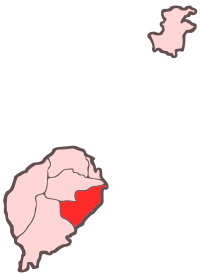 Location within São Tomé and Príncipe | |
| Coordinates: 0°13′N 6°42′E / 0.217°N 6.700°ECoordinates: 0°13′N 6°42′E / 0.217°N 6.700°E | |
| Country | São Tomé and Príncipe |
| Province/Island | São Tomé |
| Seat | Santana |
| Area | |
| • Total | 119 km2 (46 sq mi) |
| Population (2012) | |
| • Total | 18,194 |
| • Density | 150/km2 (400/sq mi) |
| Time zone | UTC+0 (UTC) |
Cantagalo is a district of São Tomé Province. Out of the seven districts that make up the equatorial Atlantic islands of São Tomé and Príncipe. It is fourth largest in terms of population and covers approximately 119 square kilometers. Its population is 18,194 (2012).[1] The district capital is Santana. Today the population may reached over 20,000 and is now becoming a part of the São Tomé City Metro Area.
The district are divided into two districts or municipalities, Santana and Ribeira Afonso.
The geography includes Ilhéu de Santana. One of the promontories in the district is Ponta da Agulha which is located to its nearby islet of Santana.
Population
- 1940: 7,854 (12.9% of the national population)
- 1950: 8,568 (14.2% of the national population)
- 1960: 9,758 (15.2% of the national population)
- 1970: 9,697 (13.1% of the national population)
- 1981: 10,435 (10.8% of the national population)
- 1991: 11,433 (9.7% of the national population)
- 2001: 13,258 (9.6% of the national population)[1]
- 2008: 15,113 (est.)[1]
- 2012: 18,194[1]
Settlements
The main settlement is the town Santana. Other settlements are:
Points of interests
- Roça Água Izé
Politics
Cantagalo currently has seven seats in the National Assembly.[2]
References
Places adjacent to Cantagalo District | ||||||||||
|---|---|---|---|---|---|---|---|---|---|---|
| ||||||||||
| Communities | | |
|---|---|---|
| Geographical features | ||
| Sports facilities and complexes |
| |
| Culture | ||