Ilhéu Caroço
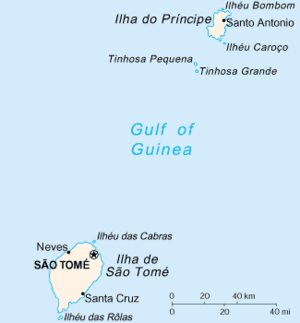 Map of São Tomé and Príncipe with Ilhéu Caroço southeast of the island of Príncipe | |
| Geography | |
|---|---|
| Location | southeast of the island of Príncipe, São Tomé and Príncipe |
| Coordinates | 1°30′50″N 7°25′52″E / 1.514°N 7.431°ECoordinates: 1°30′50″N 7°25′52″E / 1.514°N 7.431°E |
| Highest elevation | 350 m (1,150 ft) |
| Administration | |
| Demographics | |
| Population | 0 |
| Pop. density | 0 /km2 (0 /sq mi) |
| Additional information | |
| Stratovolcano | |
Ilhéu Caroço is an islet (not an island) in the Gulf of Guinea and is one of the smaller islands of São Tomé and Príncipe. The islet is located southeast of the island of Príncipe. The total area is 0,4 km² .
Wholly the islet is mountainous and elevates to 305 meters and the entire terrain is completely forested, it is considered being the highest islet in São Tomé and Príncipe. During the Ice Age, its elevation was over 400 meters. The island it not inhabited by humans. Fauna dominate the island, the dominant are just birds and of the sea including fishes and crustaceans.
History
The islet is of volcanic origin and mainly originated from a nearby volcanic vent from nearby Príncipe.
The islet was discovered by the Portuguese in January 1471 when the nearby island of Príncipe was also discovered.
On 1 November 1929, the path that showed an annular eclipse was on the southwest edge of the island.[1] The sky was partly dark and the weather conditions were unknown.
References
- ↑ "Solar eclipse of November 1, 1929". NASA. Retrieved August 30, 2017.
Pagué District/Autonomous Region of Príncipe | ||
|---|---|---|
| Communities | 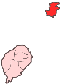 | |
| Geographical features | ||
| Buildings | ||
| Football | ||
| Major islands | |
|---|---|
| Minor islands and islets | |