Rajauli
| Dhamni Rajauli | |
|---|---|
| Sub-Division | |
 Dhamni Rajauli Location in Bihar, India | |
| Coordinates: 24°39′0″N 85°30′0″E / 24.65000°N 85.50000°ECoordinates: 24°39′0″N 85°30′0″E / 24.65000°N 85.50000°E | |
| Country |
|
| State | Bihar |
| District | Nawada |
| Elevation | 135 m (443 ft) |
| Languages | |
| • Official | Magahi, Hindi |
| Time zone | UTC+5:30 (IST) |
| PIN | 805125 |
| Telephone code | 06336 |
| Nearest city | Nawada, Jhumari Tilaiya, Gaya |
| Literacy | 68%[1] |
| Lok Sabha constituency | Nawada |
| Avg. summer temperature | 32 °C (90 °F) |
| Avg. winter temperature | 19 °C (66 °F) |
Rajauli is a subdivision in the Nawada district of the Indian state of Bihar.
Geography
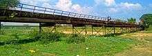
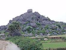
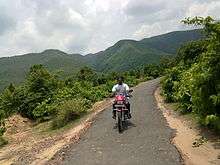
Rajauli is situated along the Dhanarjay Nadi river on National Highway 20. It is 28.1 km from the district city Nawada and 144 km from Patna. Rajauli is a sub-division that borders the state of Jharkhand, and has an elevation of 135 m above sea level. Rajauli is mainly surrounded by small and mid-range mountains including Lomash Rishi and Shringi Rishi Parvat.[2] More than 100 villages make up Rajauli district.
Rajauli was once home to monsoon and prairie forest. The principal trees were sakhua, paisar, khair, Shisham, parmi, salaiya simar, kendu and peepal. The forest and wild life have almost completely disappeared.
Language
Magahi is the local language.
Politics
LJP, BJP and RJD are the major political parties.
Transport
The nearest airport is Gaya Airport, 72 km distant.
The nearest railway station is at Dilwa, 19 km away. A limited number of passenger trains stop there. The bigger stations are Koderma (32 km away) and Gaya Junction (70 km away).
Rajauli is on NH 31 and well-connected by bus services. Buses reacg Patna, Gaya and Ranchi. Most buses on this route stop at Rajauli or at Chhapra for food. For most buses travelling between Patna and Ranchi, Rajauli is a meal stop.
Local people come to Rajauli using their bicycles, Jugaads, cars or tractors.
History
Rajauli played a significant role in the Sikh religion. A large fort-like building in the center of the town is called ‘sangat’, meaning "a body of men and women who meet religiously specially in presence of ‘Guru Granth Sahib’". A famous fair of Guru Nanak Gurpurab takes place there.
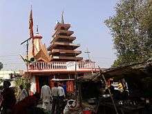
Religious places
People pray in temples and mosques. Temples include the Bajrangbali temple, Devi Mandap, Shivalaya, Manokamna dham, Bajrangbali,kali mandil and some other temples.
Religion
Shivalay temple is located near Dhanarjay River.
Education
- Maa Mathurasini Mahavidyalaya
- Rajauli Inter Vidyalaya
- Project Kanya Uccha Vidhyalala
- Rajkiye Kanya Madhya Vidhyalaya
- Rajkiye Uccha Vidhyalaya
- Saptrashi Degree College
- Saraswati Shishu/vidya Mandir
- Dayanand Anglo vidyalaya (DAV)
- South city international public school
- Brilliant Public School
- Tara Memorial Residential school
- Superfast competition centre
- Rajeev Gandhi computer Saksharta mission
Economy
Agriculture
Rajauli has clay loam soil.[3] The accumulation of rain or flood water over a considerable part of the district makes the land fit for paddy cultivation. Principal crops are paddy, wheat, gram, maze, arhar, khesari, peas, sugarcane, potatoes, chillies and mung. Aghani or winter rice is usually cultivated in the lowlands.
Business
Nearly half the population of Rajauli is engaged in small- and medium-sized businesses. Balushahi (a type of sweet made from paneer) is one of the popular takeaways from this place. One of the major businesses in Rajauli is the marketing of agricultural produce. Local merchants sell cloth, kirana, manihari, medicines, and local furniture. Major brands including HERO, Honda, Duke, Mahindra, BAZAZ, Uninor, Idea, and Airtel have authorized dealers in Rajauli. The weekly Friday Hat at Bajrangbali Chowk is popular. A few mills, including the rice mill Navdurga Agrotech Pvt., processes raw and export to other states.
References
- ↑ "Rajauli City Population Census 2011 - Bihar". www.census2011.co.in.
- ↑ "Map and weather of Rajauli".
- ↑ District profile Rajauli