Sherwood Shores, Texas
| Sherwood Shores, Texas | |
|---|---|
| Census-designated place | |
 Sherwood Shores  Sherwood Shores | |
| Coordinates: 33°51′08″N 96°49′04″W / 33.85222°N 96.81778°WCoordinates: 33°51′08″N 96°49′04″W / 33.85222°N 96.81778°W | |
| Country | United States |
| State | Texas |
| County | Grayson |
| Area[1] | |
| • Total | 4.041 sq mi (10.47 km2) |
| • Land | 2.849 sq mi (7.38 km2) |
| • Water | 1.192 sq mi (3.09 km2) |
| Elevation | 718 ft (219 m) |
| Population (2010)[1] | |
| • Total | 1,190 |
| • Density | 417.7/sq mi (161.3/km2) |
| Time zone | UTC-6 (Central (CST)) |
| • Summer (DST) | UTC-5 (CDT) |
| Area code(s) | 940 |
| GNIS feature ID | 2652414[2] |
Sherwood Shores is an unincorporated community and census-designated place in Grayson County, Texas, United States. Its population was 1,190 as of the 2010 census.[1] The community is located on the Red River, which forms the state line with Oklahoma.
Geography
According to the U.S. Census Bureau, the community has an area of 4.041 square miles (10.47 km2); 2.849 square miles (7.38 km2) of its area is land, and 1.192 square miles (3.09 km2) is water.[1]
References
- 1 2 3 4 "2010 Census Gazetteer Files - Places: Texas". U.S. Census Bureau. Retrieved March 18, 2017.
- ↑ "Sherwood Shores". Geographic Names Information System. United States Geological Survey.
Municipalities and communities of Grayson County, Texas, United States | ||
|---|---|---|
| Cities | 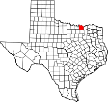 | |
| Towns | ||
| CDPs | ||
| Other unincorporated communities | ||
| Footnotes | ‡This populated place also has portions in an adjacent county or counties | |
This article is issued from
Wikipedia.
The text is licensed under Creative Commons - Attribution - Sharealike.
Additional terms may apply for the media files.