| Historic site |
Image |
Location |
Nearest city |
County |
Coordinates |
Supervising agency |
Notes |
| Acton State Historic Site |
 |
FM 167 |
Acton |
Hood |
32°26′25″N 97°41′5″W / 32.44028°N 97.68472°W / 32.44028; -97.68472 (Acton State Historic Site) |
THC |
|
Battleship Texas State Historic Site  ⁕ ⁕ |
.jpg)
 More images More images |
3523 Independence Pkwy S. |
LaPorte |
Harris |
29°45′21″N 95°5′23″W / 29.75583°N 95.08972°W / 29.75583; -95.08972 (Battleship Texas State Historic Site) |
TPWD |
|
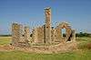
| Caddo Mounds State Historic Site |
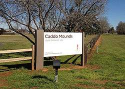
More images |
1649 W. SH 21 |
Alto |
Cherokee |
31°35′47″N 95°8′55″W / 31.59639°N 95.14861°W / 31.59639; -95.14861 (Caddo Mounds State Historic Site) |
THC |
|
| Casa Navarro State Historic Site⁕⁑ |
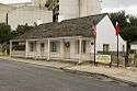 |
228 S. Laredo St. |
San Antonio |
Bexar |
29°25′23″N 98°29′51″W / 29.42306°N 98.49750°W / 29.42306; -98.49750 (Casa Navarro State Historic Site) |
THC |
|
| Confederate Reunion Grounds State Historic Site |

More images |
1738 FM 2705 |
Mexia |
Limestone |
31°38′1″N 96°33′26″W / 31.63361°N 96.55722°W / 31.63361; -96.55722 (Confederate Reunion Grounds State Historic Site) |
THC |
|
| Eisenhower Birthplace State Historic Site⁑ |

More images |
609 S. Lamar Ave. |
Denison |
Grayson |
33°44′59″N 96°32′3″W / 33.74972°N 96.53417°W / 33.74972; -96.53417 (Eisenhower Birthplace State Historic Site) |
THC |
|
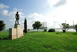
Fannin Battleground State Historic Site |
 |
734 FM 2506 |
Fannin |
Goliad |
28°41′11″N 97°14′2″W / 28.68639°N 97.23389°W / 28.68639; -97.23389 (Fannin Battleground State Historic Site) |
THC |
|
Fanthorp Inn State Historic Site ⁕ ⁕ |

More images |
579 S. Main St. |
Anderson |
Grimes |
30°28′59″N 95°59′2″W / 30.48306°N 95.98389°W / 30.48306; -95.98389 (Fanthorp Inn State Historic Site) |
TPWD |
Part of Anderson Historic District |
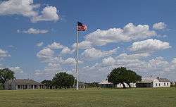
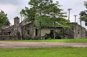
| Fort Griffin State Historic Site⁕ |
More images |
1701 N. US 283 |
Albany |
Jones |
32°55′11″N 99°13′45″W / 32.91972°N 99.22917°W / 32.91972; -99.22917 (Fort Griffin State Historic Site) |
THC |
|
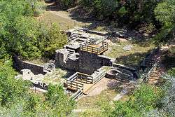
| Fort Lancaster State Historic Site⁕ |

More images |
629 Ft. Lancaster Rd. |
Sheffield |
Pecos |
30°39′34″N 101°41′36″W / 30.65944°N 101.69333°W / 30.65944; -101.69333 (Fort Lancaster State Historic Site) |
THC |
|
| Fort Leaton State Historic Site⁕ |
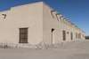
More images |
FM 170 E. |
Presidio |
Presidio |
29°32′33″N 104°19′37″W / 29.54250°N 104.32694°W / 29.54250; -104.32694 (Fort Leaton State Historic Site) |
TPWD |
|
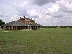
| Fort McKavett State Historic Site |
More images |
7066 FM 864 |
Fort McKavett |
Menard |
30°49′28″N 100°6′38″W / 30.82444°N 100.11056°W / 30.82444; -100.11056 (Fort McKavett State Historic Site) |
THC |
|
| Fort Richardson State Park and Historic Site⁕⁑ |
More images |
228 Park Road 61 |
Jacksboro |
Jack |
33°12′22″N 98°9′25″W / 33.20611°N 98.15694°W / 33.20611; -98.15694 (Fort Richardson State Park and Historic Site) |
TPWD |
|
| Fulton Mansion State Historic Site⁕⁑ |
More images |
317 S. Fulton Beach Rd. |
Rockport |
Aransas |
28°3′25″N 97°2′7″W / 28.05694°N 97.03528°W / 28.05694; -97.03528 (Fulton Mansion State Historic Site) |
THC |
|
| Goliad State Park and Historic Site⁕⁑ |
More images |
108 Park Road 6 |
Goliad |
Goliad |
28°39′23″N 97°23′7″W / 28.65639°N 97.38528°W / 28.65639; -97.38528 (Goliad State Park and Historic Site) |
TPWD |
|
| Hueco Tanks State Park and Historic Site |

More images |
6900 Hueco Tanks Road No. 1 |
El Paso |
El Paso |
31°55′2″N 106°2′38″W / 31.91722°N 106.04389°W / 31.91722; -106.04389 (Hueco Tanks State Park and Historic Site) |
TPWD |
|
| Landmark Inn State Historic Site⁕⁑ |

More images |
402 E. Florence St. |
Castroville |
Medina |
29°21′18″N 98°52′29″W / 29.35500°N 98.87472°W / 29.35500; -98.87472 (Landmark Inn State Historic Site) |
THC |
|
| Levi Jordan Plantation State Historic Site⁑ |
Upload image |
7234 FM 521 |
Brazoria |
Brazoria |
28°59′57″N 95°38′54″W / 28.99917°N 95.64833°W / 28.99917; -95.64833 (Levi Jordan Plantation State Historic Site) |
THC |
|
| Lipantitlan State Historic Site |
Upload image |
Lipantitlan Park Rd. |
Orange Grove |
Nueces |
27°57′53″N 97°49′4″W / 27.96472°N 97.81778°W / 27.96472; -97.81778 (Lipantitlan State Historic Site) |
TPWD |
|
| Lyndon B. Johnson State Park and Historic Site |

More images |
Park Road 52 |
Stonewall |
Gillespie |
30°14′16″N 98°37′35″W / 30.23778°N 98.62639°W / 30.23778; -98.62639 (Lyndon B. Johnson State Park and Historic Site) |
TPWD |
|
| Magoffin Home State Historic Site⁕⁑ |
More images |
1120 Magoffin Ave. |
El Paso |
El Paso |
31°45′46″N 106°28′39″W / 31.76278°N 106.47750°W / 31.76278; -106.47750 (Magoffin Home State Historic Site) |
THC |
Part of Magoffin Historic District |
| Mission Dolores State Historic Site |
.jpg) |
701 S. Broadway St. |
San Augustine |
San Augustine |
31°31′27″N 94°6′49″W / 31.52417°N 94.11361°W / 31.52417; -94.11361 (Mission Dolores State Historic Site) |
THC |
|
| Mission Rosario State Historic Site |
Upload image |
US 59 |
Goliad |
Goliad |
28°38′44″N 97°26′23″W / 28.64556°N 97.43972°W / 28.64556; -97.43972 (Mission Rosario State Historic Site) |
TPWD |
|
| Monument Hill and Kreische Brewery State Historic Sites⁕ |
More images |
414 Loop 92 |
La Grange |
Fayette |
29°53′20″N 96°52′31″W / 29.88889°N 96.87528°W / 29.88889; -96.87528 (Monument Hill and Kreische Brewery State Historic Sites) |
TPWD |
|
| National Museum of the Pacific War⁕ |
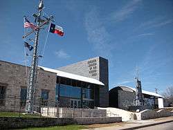
More images |
340 E. Main St. |
Fredericksburg |
Gillespie |
30°16′19″N 98°52′2″W / 30.27194°N 98.86722°W / 30.27194; -98.86722 (National Museum of the Pacific War) |
THC |
|
| Port Isabel Lighthouse State Historic Site |
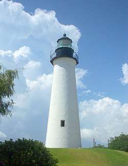
More images |
421 E. Queen Isabella Blvd. |
Port Isabel |
Cameron |
26°4′41″N 97°12′26″W / 26.07806°N 97.20722°W / 26.07806; -97.20722 (Port Isabel Lighthouse State Historic Site) |
TPWD |
|
| Sabine Pass Battleground State Historic Site |
 |
6100 Dowling Rd. |
Port Arthur |
Jefferson |
29°43′43″N 93°52′30″W / 29.72861°N 93.87500°W / 29.72861; -93.87500 (Sabine Pass Battleground State Historic Site) |
THC |
|
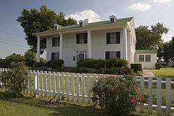
| Sam Bell Maxey House State Historic Site⁕⁑ |
.jpg)
More images |
812 S. Church St. |
Paris |
Lamar |
33°39′14″N 95°33′17″W / 33.65389°N 95.55472°W / 33.65389; -95.55472 (Sam Bell Maxey House State Historic Site) |
THC |
|
| Sam Rayburn House State Historic Site⁑ |
 |
890 W. SH 56 |
Bonham |
Fannin |
33°34′10″N 96°12′27″W / 33.56944°N 96.20750°W / 33.56944; -96.20750 (Sam Rayburn House State Historic Site) |
THC |
|
| San Felipe de Austin State Historic Site |

More images |
15945 FM 1458 |
San Felipe |
Austin |
29°48′25″N 96°5′51″W / 29.80694°N 96.09750°W / 29.80694; -96.09750 (San Felipe de Austin State Historic Site) |
THC |
|
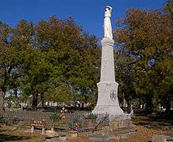
| San Jacinto Battleground State Historic Site⁕ |

More images |
3523 Independence Pkwy S. |
LaPorte |
Harris |
29°44′18″N 95°4′41″W / 29.73833°N 95.07806°W / 29.73833; -95.07806 (San Jacinto Battleground State Historic Site) |
TPWD |
|
| Seminole Canyon State Park and Historic Site |

More images |
US 90 |
Comstock |
Val Verde |
29°42′0″N 101°18′47″W / 29.70000°N 101.31306°W / 29.70000; -101.31306 (Seminole Canyon State Park and Historic Site) |
TPWD |
|
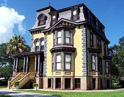
| Starr Family Home State Historic Site⁕ |
.jpg)
More images |
407 W. Travis St. |
Marshall |
Harrison |
32°32′30″N 94°22′15″W / 32.54167°N 94.37083°W / 32.54167; -94.37083 (Starr Family Home State Historic Site) |
THC |
|
| Varner–Hogg Plantation State Historic Site⁕⁑ |
.jpg)
More images |
1702 N. 13th St. |
West Columbia |
Brazoria |
29°9′45″N 95°38′28″W / 29.16250°N 95.64111°W / 29.16250; -95.64111 (Varner–Hogg Plantation State Historic Site) |
THC |
|
| Washington-on-the-Brazos State Historic Site |

More images |
23400 Park Road 12 |
Washington |
Washington |
30°19′25″N 96°9′17″W / 30.32361°N 96.15472°W / 30.32361; -96.15472 (Washington-on-the-Brazos State Historic Site) |
TPWD |
|
| Zaragoza Birthplace State Historic Site⁕ |
 |
Calle Cinco de Mayo at Lopez Rd. |
Goliad |
Goliad |
28°38′50″N 97°22′59″W / 28.64722°N 97.38306°W / 28.64722; -97.38306 (Zaragoza Birthplace State Historic Site) |
TPWD |
|