National Register of Historic Places listings in Sierra County, New Mexico
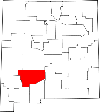
Location of Sierra County in New Mexico
This is a list of the National Register of Historic Places listings in Sierra County, New Mexico.
This is intended to be a complete list of the properties and districts on the National Register of Historic Places in Sierra County, New Mexico, United States. Latitude and longitude coordinates are provided for many National Register properties and districts; these locations may be seen together in a map.[1]
There are 32 properties and districts listed on the National Register in the county. All places within the county on the National Register are also listed on the State Register of Cultural Properties.
- This National Park Service list is complete through NPS recent listings posted October 11, 2018.[2]
| Bernalillo – Catron – Chaves – Cibola – Colfax – Curry – De Baca – Doña Ana – Eddy – Grant – Guadalupe – Harding – Hidalgo – Lea – Lincoln – Los Alamos – Luna – McKinley – Mora – Otero – Quay – Rio Arriba – Roosevelt – San Juan – San Miguel – Sandoval – Santa Fe – Sierra – Socorro – Taos – Torrance – Union – Valencia |
Current listings
| [3] | Name on the Register[4] | Image | Date listed[5] | Location | City or town | Description |
|---|---|---|---|---|---|---|
| 1 | Alert-Hatcher Building | 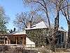 |
April 20, 1995 (#95000460) |
Southeastern corner of the junction of 2nd Ave. and Main St. 32°55′12″N 107°34′06″W / 32.92°N 107.568333°W |
Hillsboro | |
| 2 | Archeological Site No. LA1119 |  |
December 16, 1989 (#88000489) |
Address Restricted |
Truth or Consequences | |
| 3 | Archeological Site No. LA49016 | |
December 16, 1989 (#88000484) |
Address Restricted |
Truth or Consequences | |
| 4 | Archeological Site No. LA49030 | |
December 16, 1989 (#88000486) |
Address Restricted |
Truth or Consequences | |
| 5 | Archeological Site No. LA50548 | |
December 16, 1989 (#88000488) |
Address Restricted |
Truth or Consequences | |
| 6 | Archeological Site No. LA517 | |
December 16, 1989 (#88000473) |
Address Restricted |
Truth or Consequences | |
| 7 | William H. Bucher House | April 20, 1995 (#95000461) |
300 W. Main St. 32°55′11″N 107°34′11″W / 32.919722°N 107.569722°W |
Hillsboro | ||
| 8 | Camino Real-Jornada Lakes Section | |
April 8, 2011 (#11000167) |
Address Restricted |
Engle vicinity | part of the Camino Real in New Mexico, AD 1598-1881 Multiple Property Submission |
| 9 | Camino Real-Point of Rocks Section | |
April 8, 2011 (#11000171) |
Address Restricted |
Rincon vicinity | part of the Camino Real in New Mexico, AD 1598-1881 Multiple Property Submission |
| 10 | Camino Real-Yost Draw Section | |
April 8, 2011 (#11000163) |
Address Restricted |
Engle vicinity | part of the Camino Real in New Mexico, AD 1598-1881 Multiple Property Submission |
| 11 | Chambers Canyon Site (LA49028) | |
December 16, 1989 (#88000485) |
Address Restricted |
Truth or Consequences | |
| 12 | Elephant Butte Dam | 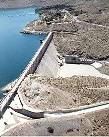 |
April 9, 1979 (#79001556) |
Northwest of Elephant Butte off State Road 51 33°09′17″N 107°11′31″W / 33.154722°N 107.191944°W |
Elephant Butte | |
| 13 | Elephant Butte Historic District | February 10, 1997 (#96001616) |
Roughly along State Road 51 from the Elephant Butte Dam to Mescal Canyon and along State Road 52 from Ash Canyon to Long Ridge 33°08′56″N 107°11′27″W / 33.148889°N 107.190833°W |
Elephant Butte | ||
| 14 | Elephant Butte Irrigation District | August 8, 1997 (#97000822) |
Roughly along U.S. Route 85 between its junction with State Road 90 and the El Paso city limits 32°12′58″N 106°57′31″W / 32.216111°N 106.958611°W |
Las Cruces | Extends into Doña Ana County and El Paso County, Texas | |
| 15 | Fort McRae | |
April 7, 2005 (#05000258) |
Address Restricted |
Elephant Butte | |
| 16 | Hillsboro High School | 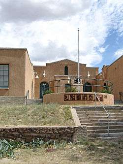 |
April 15, 1993 (#93000254) |
Southeastern corner of the junction of Elenora St. and 1st Ave. 32°55′10″N 107°34′01″W / 32.919444°N 107.566944°W |
Hillsboro | |
| 17 | Hillsboro Peak Lookout Tower and Cabin | 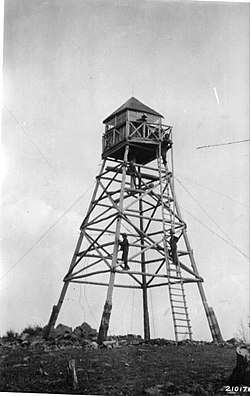 |
January 28, 1988 (#87002475) |
Gila National Forest 32°57′09″N 107°46′43″W / 32.9525°N 107.778611°W |
Hillsboro | |
| 18 | Horse Island Site (LA48996) | |
May 16, 1988 (#88000478) |
Address Restricted |
Truth or Consequences | |
| 19 | Hot Springs Bathhouse and Commercial Historic District in Truth or Consequences | May 10, 2005 (#05000409) |
Roughly bounded by Post, Ban Patten, Pershing, and Main Sts. 33°07′40″N 107°15′17″W / 33.127778°N 107.254722°W |
Truth or Consequences | ||
| 20 | Kettle Top Butte Site (LA48995) | |
May 16, 1988 (#88000477) |
Address Restricted |
Truth or Consequences | |
| 21 | Longbottom Canyon Site (LA49033) | |
December 16, 1989 (#88000487) |
Address Restricted |
Truth or Consequences | |
| 22 | Meyers House | April 20, 1995 (#95000463) |
Northern side of Main St. between 4th and 5th Aves. 32°55′12″N 107°34′15″W / 32.92°N 107.570833°W |
Hillsboro | ||
| 23 | George Tambling Miller and Ninette Stocker Miller House | 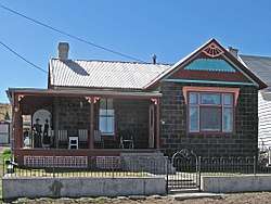 |
April 20, 1995 (#95000465) |
South side of Elenora St., west of Union Church 32°55′09″N 107°34′05″W / 32.919167°N 107.568056°W |
Hillsboro | Late-Victorian architecture, built of recycled gold ore.[6] |
| 24 | Monticello Point Archeological District | |
May 16, 1988 (#88000476) |
Address Restricted |
Truth or Consequences | |
| 25 | Palomas Narrows North (LA38755) | |
December 16, 1989 (#88000475) |
Address Restricted |
Truth or Consequences | |
| 26 | Palomas Narrows South (LA49007) | |
December 16, 1989 (#88000479) |
Address Restricted |
Truth or Consequences | |
| 27 | Percha Creek Bridge | 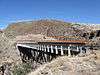 |
July 15, 1997 (#97000731) |
State Road 90 over Percha Creek 32°55′00″N 107°36′20″W / 32.916667°N 107.605556°W |
Hillsboro | |
| 28 | Percha Diversion Dam | April 6, 1979 (#79001555) |
2 miles (3.2 km) northeast of Arrey 32°52′06″N 107°18′11″W / 32.868333°N 107.303056°W |
Arrey | ||
| 29 | Will M. Robins House | 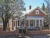 |
April 20, 1995 (#95000462) |
Southwestern corner of the junction of Main St. and 5th Ave. 32°55′10″N 107°34′18″W / 32.919444°N 107.571667°W |
Hillsboro | |
| 30 | Cornelius Sullivan House | April 20, 1995 (#95000459) |
Southwestern corner of the junction of Elenora and 1st Ave. 32°55′10″N 107°34′04″W / 32.919444°N 107.567778°W |
Hillsboro | ||
| 31 | Carrie Tingley Hospital Historic District | March 15, 2005 (#03001546) |
992 Broadway 33°07′19″N 107°15′38″W / 33.121944°N 107.260556°W |
Truth or Consequences | ||
| 32 | US Post Office-Truth or Consequences Main | 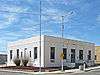 |
February 23, 1990 (#90000141) |
300 Main St.[7] 33°07′47″N 107°15′10″W / 33.129722°N 107.252778°W |
Truth or Consequences | |
| 33 | John M. Webster House | 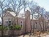 |
April 20, 1995 (#95000464) |
Southeastern corner of the junction of Main St. and 5th Ave. 32°55′10″N 107°34′16″W / 32.919444°N 107.571111°W |
Hillsboro |
See also
| Wikimedia Commons has media related to National Register of Historic Places in Sierra County, New Mexico. |
References
- ↑ The latitude and longitude information provided in this table was derived originally from the National Register Information System, which has been found to be fairly accurate for about 99% of listings. For about 1% of NRIS original coordinates, experience has shown that one or both coordinates are typos or otherwise extremely far off; some corrections may have been made. A more subtle problem causes many locations to be off by up to 150 yards, depending on location in the country: most NRIS coordinates were derived from tracing out latitude and longitudes from USGS topographical quadrant maps created under the North American Datum of 1927, which differs from the current, highly accurate WGS84 GPS system used by most on-line maps. Chicago is about right, but NRIS longitudes in Washington are higher by about 4.5 seconds, and are lower by about 2.0 seconds in Maine. Latitudes differ by about 1.0 second in Florida. Some locations in this table may have been corrected to current GPS standards.
- ↑ "National Register of Historic Places: Weekly List Actions". National Park Service, United States Department of the Interior. Retrieved on October 11, 2018.
- ↑ Numbers represent an ordering by significant words. Various colorings, defined here, differentiate National Historic Landmarks and historic districts from other NRHP buildings, structures, sites or objects.
- ↑ National Park Service (2008-04-24). "National Register Information System". National Register of Historic Places. National Park Service.
- ↑ The eight-digit number below each date is the number assigned to each location in the National Register Information System database, which can be viewed by clicking the number.
- ↑ Historic Miller House
- ↑ Address based on USPS website. Accessed March 29, 2016.
| Topics | |
|---|---|
| Lists by states |
|
| Lists by insular areas | |
| Lists by associated states | |
| Other areas | |
| |
Municipalities and communities of Sierra County, New Mexico, United States | ||
|---|---|---|
| Cities | | |
| Villages | ||
| CDPs | ||
| Other communities | ||
| Ghost towns | ||
This article is issued from
Wikipedia.
The text is licensed under Creative Commons - Attribution - Sharealike.
Additional terms may apply for the media files.