Orason, Texas
| Orason, Texas | |
|---|---|
| Census-designated place | |
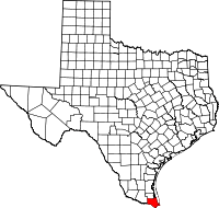
 Orason Location within the state of Texas | |
| Coordinates: 26°4′28″N 97°26′41″W / 26.07444°N 97.44472°WCoordinates: 26°4′28″N 97°26′41″W / 26.07444°N 97.44472°W | |
| Country | United States |
| State | Texas |
| County | Cameron |
| Area | |
| • Total | 0.33 sq mi (0.85 km2) |
| • Land | 0.33 sq mi (0.85 km2) |
| Elevation | 18 ft (5 m) |
| Population (2010) | |
| • Total | 129 |
| • Density | 391/sq mi (150.9/km2) |
| Time zone | UTC-6 (Central (CST)) |
| • Summer (DST) | UTC-5 (CDT) |
| FIPS code | 48-54186[1] |
Orason is a census-designated place (CDP) in Cameron County, in the U.S. state of Texas. The population was 129 at the 2010 census.[1] Prior to the 2010 census the community was part of the Chula Vista-Orason CDP. It is part of the Brownsville–Harlingen Metropolitan Statistical Area.
Geography
Orason is near the center of Cameron County, 2 miles (3 km) east of Los Fresnos and 15 miles (24 km) north of the center of Brownsville. It is bordered on the east by Chula Vista.
According to the United States Census Bureau, the Orason CDP has a total area of 0.33 square miles (0.85 km2), all of it land.[1]
References
- 1 2 3 "Geographic Identifiers: 2010 Census Summary File 1 (G001): Orason CDP, Texas". U.S. Census Bureau, American Factfinder. Retrieved July 10, 2015.
This article is issued from
Wikipedia.
The text is licensed under Creative Commons - Attribution - Sharealike.
Additional terms may apply for the media files.