Arrondissement of Nantua
| Nantua | |
|---|---|
| Arrondissement | |
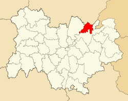 Arrondissement of Nantua in Auvergne-Rhône-Alpes | |
| Country | France |
| Region | Auvergne-Rhône-Alpes |
| Department | Ain |
| Communes | 65 |
| Subprefecture | Nantua |
| Area¹ | |
| • Total | 900 km2 (300 sq mi) |
| Population (2013) | |
| • Total | 92,122 |
| • Density | 100/km2 (270/sq mi) |
| ¹ French Land Register data, which exclude lakes, ponds, and glaciers larger than 1 km² as well as the estuaries of rivers. | |
The arrondissement of Nantua is an arrondissement of France in the Ain department in the Auvergne-Rhône-Alpes region. Since the January 2017 reorganization of the arrondissements of Ain, it has 65 communes.[1]
Composition
Cantons
The cantons of the arrondissement of Nantua are:
- Bellegarde-sur-Valserine (partly)
- Hauteville-Lompnes (partly)
- Nantua
- Oyonnax
- Pont-d'Ain
Communes
The communes of the arrondissement of Nantua, and their INSEE codes, are:
- Apremont (01011)
- Arbent (01014)
- Béard-Géovreissiat (01170)
- Bellegarde-sur-Valserine (01033)
- Belleydoux (01035)
- Bellignat (01031)
- Billiat (01044)
- Bolozon (01051)
- Boyeux-Saint-Jérôme (01056)
- Brénod (01060)
- Brion (01063)
- Ceignes (01067)
- Cerdon (01068)
- Challes-la-Montagne (01077)
- Champfromier (01081)
- Chanay (01082)
- Charix (01087)
- Châtillon-en-Michaille (01091)
- Chevillard (01101)
- Condamine (01112)
- Confort (01114)
- Dortan (01148)
- Échallon (01152)
- Géovreisset (01171)
- Giron (01174)
- Groissiat (01181)
- Injoux-Génissiat (01189)
- Izenave (01191)
- Izernore (01192)
- Jujurieux (01199)
- Labalme (01200)
- Lancrans (01205)
- Lantenay (01206)
- Leyssard (01214)
- Lhôpital (01215)
- Maillat (01228)
- Martignat (01237)
- Matafelon-Granges (01240)
- Mérignat (01242)
- Montanges (01257)
- Montréal-la-Cluse (01265)
- Nantua (01269)
- Neuville-sur-Ain (01273)
- Les Neyrolles (01274)
- Nurieux-Volognat (01267)
- Outriaz (01282)
- Oyonnax (01283)
- Peyriat (01293)
- Plagne (01298)
- Le Poizat-Lalleyriat (01204)
- Poncin (01303)
- Pont-d'Ain (01304)
- Port (01307)
- Priay (01314)
- Saint-Alban (01331)
- Saint-Germain-de-Joux (01357)
- Saint-Jean-le-Vieux (01363)
- Saint-Martin-du-Frêne (01373)
- Samognat (01392)
- Serrières-sur-Ain (01404)
- Sonthonnax-la-Montagne (01410)
- Surjoux (01413)
- Varambon (01430)
- Vieu-d'Izenave (01441)
- Villes (01448)
References
- ↑ "Arrêté n° 16-542, p 746" (PDF). Retrieved 2017-07-20.
External links
This article is issued from
Wikipedia.
The text is licensed under Creative Commons - Attribution - Sharealike.
Additional terms may apply for the media files.