Las Piñas
| Las Piñas | ||
|---|---|---|
| Highly Urbanized City | ||
| City of Las Piñas | ||
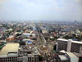
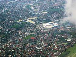 Las Piñas aerial photo along Barangays Talon and Almanza. SM Southmall at center | ||
| ||
| Nickname(s): Home of the Bamboo Organ | ||
| Motto(s): Las Piñas, Our Home | ||
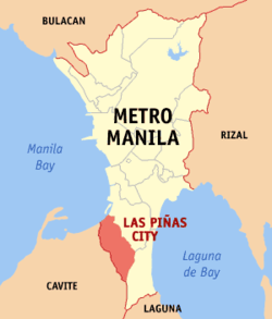 Map of Metro Manila with Las Piñas highlighted | ||
.svg.png) Las Piñas Location within the Philippines | ||
| Coordinates: 14°27′N 120°59′E / 14.45°N 120.98°ECoordinates: 14°27′N 120°59′E / 14.45°N 120.98°E | ||
| Country |
| |
| Region | National Capital Region (NCR) | |
| Province | none (Former part of Rizal province until 1975) | |
| District | Lone district | |
| Founded | 1762 or 1797 | |
| Chartered | 27 March 1907 | |
| Cityhood and HUC | 26 March 1997 | |
| Barangays | 20 (see Barangays) | |
| Government [1] | ||
| • Type | Sangguniang Panlungsod | |
| • Mayor | Imelda Aguilar | |
| • Vice Mayor | Luis Bustamante | |
| • Councilors |
List
| |
| • Electorate | 304,311 voters (2016) | |
| Area [2] | ||
| • Total | 32.69 km2 (12.62 sq mi) | |
| Elevation | 8 m (26 ft) | |
| Population (2015 census)[3] | ||
| • Total | 588,894 | |
| • Density | 18,000/km2 (47,000/sq mi) | |
| Demonym(s) | Las Piñero | |
| Time zone | UTC+8 (PST) | |
| ZIP code | 1740–1752 | |
| PSGC | 137601000 | |
| IDD : area code | +63 (0)02 | |
| Climate type | Tropical monsoon climate | |
| Income class | 1st city income class | |
| Revenue (₱) | 2,000,189,668.48 (2016) | |
| Native languages |
Tagalog Taglish Swardspeak | |
| Website |
laspinascity | |

Las Piñas, officially the City of Las Piñas, (Tagalog: Lungsod ng Las Piñas), or simply known as Las Piñas City, is a 1st class highly urbanized city in Metro Manila, Philippines. According to the 2015 census, it has a population of 588,894 people.[3]
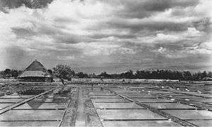
It was established as a small fishing port and became a major sea salt-producing municipality, through the use of salt evaporation ponds, dating back to the Spanish Era, the city has grown into an important residential, commercial and industrial suburb of Metro Manila.
The Sarao Motors factory, also located in Las Piñas, is the place where jeepneys are assembled piece by piece in painstaking individual production. The factory remains open to buyers and curious tourists all year round.
Las Piñas also houses SM Southmall, which has an area of 205,120 square meters and is located along Alabang–Zapote Road. The newest shopping mall development in the city is Robinsons Place Las Piñas. The first high-rise building in the city is the 16-storey residential Almanza Metropolis while more high-rise buildings will rise in the city soon including South Residences at SM Southmall a 4 tower 15 storey condominium.
Aside from being famous in music due to the historical significance of the Bamboo Organ and the yearly International Bamboo Organ Festival at St. Joseph Parish, Las Piñas is also known as the home for London College of Music Examinations of the University of West London through the Saraza Music Center which was appointed in 2013 as the first and only public examination centre in the Philippines for London College of Music. The Saraza Music Centre is an International music centre Located in BF Resort Las Piñas with International sister (co-owned) school in Gading Serpong Indonesia.
Etymology
The story about the true origin of the city's name, "Las Piñas", varies. One version mentioned, that traders from the province of Cavite and Batangas shipped their first piñas (Spanish for pineapples) for sale to this town, before they were distributed to nearby markets. Another version related that it was "Las Peñas" (the rocks), evident by the quarrying of stones and adobe, which were used to construct buildings and bridges. The old church bell, from St. Joseph Parish Church, founded by Diego Cera, has been preserved inside the church museum. An inscription on the bell states, "Siendo cura del pueblo de Laspeñas el M.R.P. Padre Diego Cera se fundió este equilón año de 1820," showing that even during the time of Diego Cera, the town's first parish priest, the town was called "Las Peñas", for some time, and eventually was renamed "Las Piñas".[4]
History
Early history
Las Piñas was one of the earliest fishing settlements on the shores of Manila Bay. It was proclaimed as a province of Manila province either in 1762 or 1797. Agustin,[5] a Spanish historian, and Fr. Juan de Medina[6] placed it at 1762. Las Piñas was formerly called "Las Pilas" due to its separation from Parañaque due to tribal conflicts. On the other hand, Manuel Buzeta recorded the date at 1797.[7] Felix Timbang was the first gobernadorcillo in 1762 while Mariano Ortiz was the first municipal president of the town of Las Piñas.[8]
Besides being famous for its Bamboo Organ, which was built by Fr. Diego Cera and completed in 1824, the town of Las Piñas was also a major war theater during the 1896 Philippine Revolution, as it was occupied by forces of Gen. Emilio Aguinaldo. Las Piñas was occupied by the Japanese during World War II and liberated by the combined American and Filipino forces.
In 1901, the municipality of Las Piñas was separated from Manila and incorporated to the newly created province of Rizal pursuant to the Philippine Commission Act No. 137. Two years later, in accordance with Act No. 942, it was combined with the town of Parañaque, with the latter as the seat of a new municipal government.
It was separated from Parañaque to become an independent municipality again on 27 March 1907 by virtue of Philippine Commission Act No. 1625. On 7 November 1975, through Presidential Decree No. 824, Las Piñas was excised from the province of Rizal to form Metro Manila. Las Piñas became one of the municipalities making up the region.
Contemporary history
On 12 February 1997, President Fidel V. Ramos signed the bill which elevated Las Piñas from municipality into a city. A plebiscite held a month after approved the city status by its residents, and Las Piñas became the 10th city of Metro Manila on 26 March 1997. The current mayor of Las Piñas is Imelda Aguilar, wife of previous city's mayor, Vergel "Nene" Aguilar.
Geography
Las Pinas is bounded to the northeast by Parañaque; to the southeast by Muntinlupa; to the west and southwest by Bacoor; and to the northwest by Manila Bay. Half of its land area is residential and the remaining half is used for commercial, industrial and institutional purposes. The present physiography of Las Piñas consists of three zones: Manila Bay, coastal margin and the Guadalupe Plateau.
Demographics
| Population census of Las Piñas | |||||||||||||||||||||||||||||||||||||||||||||||||
|---|---|---|---|---|---|---|---|---|---|---|---|---|---|---|---|---|---|---|---|---|---|---|---|---|---|---|---|---|---|---|---|---|---|---|---|---|---|---|---|---|---|---|---|---|---|---|---|---|---|
|
| ||||||||||||||||||||||||||||||||||||||||||||||||
| Source: Philippine Statistics Authority[3][9][10][11] | |||||||||||||||||||||||||||||||||||||||||||||||||
Local government
Las Piñas, like other cities of the Philippines, is a local government unit whose powers and functions are specified by the Local Government Code of the Philippines. In general, as a city, Las Piñas is headed by a mayor who heads the city's executive function and the vice mayor who heads the city's legislative function, which is composed of twelve councilors, six each from the city's two city council districts.[12] For representation, the city is considered as one district, and therefore one representative, in the country's House of Representatives.
Additionally, like other cities and municipalities, Las Piñas is subdivided into barangays.
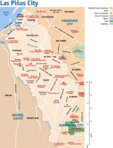
Districts and barangays
Las Piñas is divided into 20 barangays. These barangays are grouped into two legislative districts, each with its own set of representatives in the city council. District 1 comprises the northwestern half of the city while District 2, the remaining half.
| Barangays | District | Population[13] (2010) |
Area (km²) | Density (/km²) | Zip Code |
|---|---|---|---|---|---|
| Almanza Uno | 2nd | 31,049 | |||
| Daniel Fajardo | 1st | 11,503 | |||
| Elias Aldana | 1st | 11,104 | |||
| Ilaya | 1st | 6,127 | |||
| Manuyo Uno | 1st | 13,696 | |||
| Pamplona Uno | 1st | 17,862 | |||
| Pulang Lupa Uno | 1st | 35,602 | |||
| Talon Uno | 1st | 31,435 | |||
| Zapote | 1st | 20,753 | |||
| Almanza Dos | 2nd | 37,301 | |||
| C.A.A. - B. F. International | 1st | 69,660 | |||
| Manuyo Dos | 1st | 32,951 | |||
| Pamplona Dos | 2nd | 9,236 | |||
| Pamplona Tres | 1st | 32,535 | |||
| Pilar | 2nd | 30,499 | |||
| Pulang Lupa Dos | 1st | 30,779 | |||
| Talon Dos | 2nd | 45,855 | |||
| Talon Tres | 2nd | 25,967 | |||
| Talon Kuatro | 2nd | 20,112 | |||
| Talon Singko | 2nd | 38,547 |
List of mayors
Education
Twelve public high schools and 22 elementary schools were constructed to accommodate the growing number of the enrollees every year.
To date, there are 77 day care centers with feeding programs in 20 barangays within Las Piñas.
Colleges
- ABE - Las Piñas Campus
- Bernardo College
- Centro Escolar Las Piñas
- Don Carlo Cavina School
- Philippine Merchant Marine School - Las Piñas Campus
- STI College Las Piñas
- Saint Francis of Assisi College
- Southville International School and Colleges
- University of Perpetual Help System DALTA
- Dr. Filemon C. Aguilar Memorial College, a public college that offers Bachelor of Science in Accountancy, and Bachelor of Science in Business Administration (Majoring in Marketing, Financial Management and Human Resources Development Management), to deserving Las Piñeros.
- Dr. Filemon C. Aguilar Information Technology Training Institute (DFCAITTI), a public college that offer diploma courses like computer programming, computer technology, and graphic arts.
Public high schools
- Las Piñas National High School Almanza
- Las Piñas East National High School - Verdant Annex II
- Las Piñas East National High School - Equitable Annex II
- Las Piñas East National High School - Talon Village Annex II
- Las Piñas National High School
- Las Piñas National High School - Gatchalian Annnex
- Las Piñas City Technical-Vocational High School
- Las Piñas City National Senior High School - Doña Josefa Campus
- Las Piñas City National Senior High School - Talon Dos Campus
- CAA National High School
- CAA National High School - Annex
- Golden Acres National High School
- Las Piñas North National High School
- Las Piñas City National Science High School
- T.S. Cruz High School
Health
Transportation
Railway
Las Piñas is part of the route of the extension of the LRT Line 1, the South Extension Project. The actual construction will start by first quarter of 2019 once the Right-of-way issues are substantially addressed. Once Phase 2 of the project is completed, Las Piñas will be served by the LRT Line 1 through the Las Piñas and Zapote stations. The LRT Line 1 South Extension will pass to this city, reach Bacoor in Cavite and will be finished by 2023.
Road network
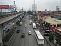
The road network of Las Piñas are radial in nature, and primarily relies on the Alabang–Zapote Road (N411), which serves as the city's road network backbone. The Manila-Cavite Expressway (formerly Coastal Road, and numbered E3), a toll expressway serves as the major traffic route towards Manila. Daang Hari, which hugs near the boundary with Muntinlupa, and the Aguinaldo Highway (N62) are the major traffic routes toward Cavite. The Muntinlupa-Cavite Expressway (MCX), that leads to South Luzon Expressway, supplements Daang Hari as an alternate to the congested Alabang-Zapote Road over Alabang and Ayala Alabang in Muntinlupa.
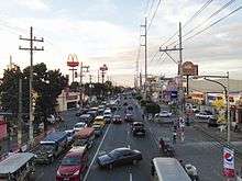
The road network in Las Piñas suffers from traffic jams, especially on the primary artery, Alabang-Zapote Road, which carried more than 70,000 vehicles daily as of 2016. Public transport, like buses and jeepneys, fill up Alabang-Zapote Road, therefore causing further congestion. The city government petitioned the Land Transportation Franchising and Regulatory Board (LTFRB) to suspend issuing of franchises on bus and jeepneys routes that uses Alabang-Zapote Road.
The Las Piñas Friendship Route network serves as the alternate routes on the congested routes, but motorists have to obtain a sticker to use them, as most roads of the network are located in privately owned subdivisions (gated communities), like BF Homes, Pilar Village, and BF Resort.
Public transport
Jeepneys and buses form the major public transport system, and most of their routes follow the Alabang-Zapote Road. Most jeepneys through Las Piñas travel between Alabang and Zapote, within the city, or Baclaran, in Parañaque. Buses usually form routes between Alabang or SM Southmall and destinations in Manila. Buses and jeepneys are blamed for the worsening congestion on Alabang-Zapote Road.
Culture
_-philippines--2015-0430--ls-.JPG)
On 22 February 1995, then President Fidel V. Ramos signed Republic Act 8003 into a law – declaring Las Piñas Church and Bamboo Organ, Las Piñas Bridge, Asinan Area, Father Diego Cera Bridge, and Old District Hospital as tourist spots of Las Piñas.[14]
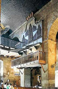
Las Piñas is famous for its Bamboo Organ located inside the St. Joseph Parish Church in the old district of the city. Built in 1824 by a Catholic priest, Fr. Diego Cera, it is the only organ of its kind in the world with organ pipes mostly made out of bamboo. This famous organ is praised for its unique, rare, and melodious sound.
Las Piñas Historical Corridor Project
The Las Piñas Historical Corridor Project was a program laid to restore the Old Town of Las Piñas. It was launched at the Malacañan Heroes' Hall on 13 November 1997. The project aims to educate the people of Las Piñas along the tourist corridor.[14] 19 structures were included along the historical corridor:
- Boundary Arc
- Bulwagang Ezekiel Moreno
- Santuario de San Ezekiel Moreno
- Police and Fire Station
- Public Library
- Plaza Quezon – designated as the Freedom Park in the City of Las Piñas by City Ordinance No. 700-06, Series of 2006. This was in accordance with Section 15 of Batas Pambansa Blg. 880, otherwise known as the "Public Assembly Act of 1985".[15]
- Central Elementary School
- E. Aldana Police Station
- Fr. Diego Cera Bridge
- Historical and Cultural Museum
- Las Piñas Fish Port
- Irasan Center
- Las Piñas Manpower Youth Council – TESDA Building
- Zapote Police Station
- Las Piñas General Hospital and Satellite Trauma Center
- Zapote Bridge
- Brgy. Hall of Zapote
- Centennial Flyover
- Molino Dam
Las Piñas Town Feast
The town fiesta of Las Piñas is celebrated every first Sunday of May each year to honor its patron saint, Saint Joseph. Saint Joseph's Day celebration is centered in St. Joseph Parish Church in the old poblacion of Las Piñas in Brgy. Daniel Fajardo on Padre Diego Cera Ave. (Quirino Ave.). Las Piñas was also the home of Mary Immaculate Parish Church, popularly known as the Nature Church, designed by Architect Francisco "Bobby" Mañosa.[16]
Las Piñas is also home to unique festivals such as:
- International Bamboo Organ Festival – a music festival held in February celebrating the music of the unique Bamboo Organ with performances by local and foreign classical artists[17]
- Waterlily Festival – every 27 July[18]
- "Parol" or Lantern Festival – celebrated during Christmas season[19]
- Las Piñas City Historical Festival – celebrated every March to commemorate significant historical events that happened in the city
List of cultural properties of Las Piñas
| Cultural Property wmph identifier |
Site name | Description | Province | City/Municipality | Address/Location | Coordinates | Image |
|---|---|---|---|---|---|---|---|
| De La Cruz House | The original owner was Genoveva Quilatan de la Cruz, from a political family.[20] | National Capital Region | Las Piñas | 716 San Francisco Street | 14°28′41″N 120°58′45″E / 14.478003°N 120.979163°E |  | |
| Santos House | The house was constructed in 1932 by carpenter Pedro Arevalo. The original owners were Maximo Santos (musician) and his wife, Alita Loreto.[20] | National Capital Region | Las Piñas | 692 San Francisco Street | 14°28′45″N 120°58′48″E / 14.479031°N 120.980132°E | | |
| Tionquiao House | The house was constructed in 1947 by carpenter Sebastian Velasquez. The original owner was Ilidian Tionquiao, a dressmaker and businesswoman.[20] | National Capital Region | Las Piñas | 680 San Francisco Street | 14°28′46″N 120°58′50″E / 14.479451°N 120.980492°E | | |
| Cristobal House | The house was constructed in 1946. Its interiors were remodeled by Architect Dagurberto Cristobal Jr., son of the original owner, Manuel Santos Cristobal. The original owner used to work for Philippine Airlines as one of the pioneer plane technicians in the country.[20] | National Capital Region | Las Piñas | 624 San Francisco Street | 14°28′54″N 120°58′58″E / 14.481687°N 120.982643°E | | |
| De La Cruz House | The original owners were Mercedes de la Cruz and Felisa de la Cruz, who managed an embroidery business before.[20] | National Capital Region | Las Piñas | 591 San Francisco Street | 14°28′58″N 120°59′02″E / 14.482730°N 120.983872°E | | |
| Hernandez House | Catalina Hernandez was the mother of the original owner.[20] | National Capital Region | Las Piñas | 578 San Francisco Street | 14°28′59″N 120°59′02″E / 14.483093°N 120.983872°E | | |
| Jose House | The house was constructed in 1942 by Ingracio Jose Sr., an oil and air brush painter and sculptor.[20] | National Capital Region | Las Piñas | 043 Padre Diego Cera Avenue (Quirino Avenue at present) | 14°28′59″N 120°59′02″E / 14.483128°N 120.983805°E | | |
| De Leon House | The house was constructed in 1922 by Roberto de Leon. The house was turned into a local headquarters by guerrillas during the World War II.[20] | National Capital Region | Las Piñas | 810 San Jose Street | 14°28′57″N 120°58′57″E / 14.482522°N 120.982605°E | | |
| Ortiz-Alvarez House | The house was constructed in 1930s – used to be a restaurant during the American Period. Felisa Ortiz and Marcelo Alvarez were the grandparents of the current owner.[20] | National Capital Region | Las Piñas | Padre Diego Cera Avenue (Quirino Avenue at present) | 14°28′56″N 120°58′59″E / 14.482294°N 120.983089°E | | |
| De La Cruz House | The house was constructed in 1950s. Gloria de la Cruz, a retired piano teacher, was the current owner.[20] | National Capital Region | Las Piñas | Padre Diego Cera Avenue (Quirino Avenue at present) | 14°28′57″N 120°58′59″E / 14.482552°N 120.982997°E | | |
| Vasquez House | The house was constructed in 1950s. At present, the house was used as a funeraria, or funeral home.[20] | National Capital Region | Las Piñas | 068 Padre Diego Cera Avenue (Quirino Avenue at present) | 14°29′00″N 120°59′01″E / 14.483446°N 120.983731°E | | |
| Jimenez House | The house was constructed in 1930s. Perdo Jimenez, an office clerk at the Manila Post Office in Lawton, and his wife, Ezperanza Alvarez-Jimenez, an embroider, were the original owners.[20] | National Capital Region | Las Piñas | Padre Diego Cera Avenue (Quirino Avenue at present) | 14°28′56″N 120°58′58″E / 14.482244°N 120.982772°E | | |
| Fajardo House | The house was constructed in 1939. Felang and Silvestre Fajardo, carpenter were the original owners of the house.[20] | National Capital Region | Las Piñas | 094 Padre Diego Cera Avenue (068 Quirino Avenue at present) | 14°28′56″N 120°58′58″E / 14.482153°N 120.982644°E | | |
| Cristobal House | The house was constructed in 1919. Santiago Cristobal was the original owner of the house.[20] | National Capital Region | Las Piñas | 152 Padre Diego Cera Avenue (Quirino Avenue at present) | 14°28′49″N 120°58′50″E / 14.480206°N 120.980676°E | | |
| Lara House | The house was constructed in 1880s. Calixto Lara, who used to own irasan, or salt beds, and his wife, Andeng Velasquez were the original owners of the house. The house became the Municipal Hall of Las Piñas during 1905–1913.[20] | National Capital Region | Las Piñas | 160 Padre Diego Cera Avenue (Quirino Avenue at present) | 14°28′46″N 120°58′48″E / 14.479344°N 120.979895°E | 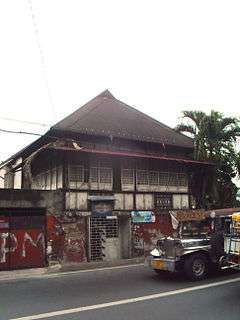 | |
| Hernandez House | The house was constructed in 1927 by Luis Eusebio. He was captured by the Japanese soldiers because of his suspected affiliation with a local guerrilla.[20] | National Capital Region | Las Piñas | 253 Padre Diego Cera Avenue (Quirino Avenue at present) | 14°28′39″N 120°58′41″E / 14.477621°N 120.978123°E | | |
| Viñalon House | Baldomero Viñalon, former mayor of the Municipality of Muntinlupa, used to own the house.[20] | National Capital Region | Las Piñas | 912–914 Aldana Street corner Ilaya Street | 14°28′41″N 120°58′42″E / 14.478049°N 120.978251°E | | |
| Alvarez House | The house was constructed in 1920. Lustina Aldana Alvarez was the original owner of the house.[20] | National Capital Region | Las Piñas | 934 Aldana Street | 14°28′40″N 120°58′41″E / 14.477911°N 120.978101°E | | |
| Cristobal-Julia House | Victoria Cristobal and Monico Julia were the original owners of the house.[20] | National Capital Region | Las Piñas | 218 Aldana Street | 14°28′40″N 120°58′41″E / 14.477751°N 120.977917°E | |
Notable people
- Amani Aguinaldo, UFL football player, member of Philippine Azkals
- Kevin Alas, PBA basketball player, member of Gilas Pilipinas and NLEX Road Warriors
- Zara Aldana or Zephorah Aldana Mayon, Mutya ng Pilipinas 2007 Asia Pacific International and former housemate of Pinoy Big Brother: Celebrity Edition 2
- Raymond Bagatsing, actor
- McNeal (Awra) Briguela, child actor Of Ang Probinsyano
- Ely Buendia, songwriter, vocalist and guitarist of Eraserheads, Pupil, Oktaves and Apartel
- Sef Cadayona, actor and dancer
- Tirso Cruz III, actor
- Jen Da Silva, model, dancer as part of the 26K girls of Kapamilya, Deal or No Deal and former housemate of Pinoy Big Brother: Celebrity Edition 2
- Ranidel de Ocampo, PBA basketball player, member of Gilas Pilipinas and TNT KaTropa
- Mr. Fu, radio jock, comedian and host
- Michelle Gavagan, Miss Philippines Fire 2011
- Enrique Gil, artist in ABS-CBN, lives in BF Executive Las Pinas
- Nikki Gil, singer, actress, TV host and former MYX VJ
- Ruben Gonzaga, comedian and winner of Pinoy Big Brother: Celebrity Edition 2
- Allan K., co-host of Eat Bulaga
- Pauleen Luna, actress
- Pol Medina, Jr., author of Pugad Baboy
- Jennylyn Mercado, actress and singer
- Iwa Moto, actress
- Sitti Navarro, bossa nova singer
- Amy Perez, actress, host and radio anchor
Sister cities
Local
- Parañaque, Metro Manila
- Muntinlupa, Metro Manila
- Pasay, Metro Manila
- Bacoor, Cavite
- Samal, Davao del Norte
International


See also
References
- ↑
- ↑ "Province: NCR, FOURTH DISTRICT (Not a Province)". PSGC Interactive. Quezon City, Philippines: Philippine Statistics Authority. Retrieved 12 November 2016.
- 1 2 3 Census of Population (2015). "National Capital Region (NCR)". Total Population by Province, City, Municipality and Barangay. PSA. Retrieved 20 June 2016.
- ↑ Pransism (2011-11). "Las Piñas (St. Joseph Church): Home of the Bamboo Organ". Back Trails. Retrieved 7 April 2013.
- ↑ Cavada y Méndez de Vigo, Agustín de la (1876). Historia geográfica, geológica y estadiśtica de Filipinas. Con datos geográficos, geológicos y estadiśticos de las islas de Luzon, Visayas, Mindanao y Joló; y los que corresponden a las islas Batanes, Calamianes, Balabac, Mindoro, Masbate, Ticao y Burias, situadas al n. so. y s. de Luzon (PDF). Manila: Imp. de Ramirez y Giraudier.
- ↑ de Medina, Juan S. (1893). Historia de los sucesos de la Orden de N. gran P. S. Agustín, de estas Islas Filipinas... / compuesta por el venerable Fray Juan de Medina. Sucesos que los religiosos de la Orden de N. P. S. Agustín han tenido en las Islas Filipinas... / compuesta por el Padre Pedro del Viva. Manila: Tipo-Litografía de Chofré y Comp. p. 486.
- ↑ Buzeta, Manuel (1851). Diccionario geográfico, estadístico, histórico de las Islas Filipinas ... / por Manuel Buzeta y Felipe Bravo. Madrid: Imprenta de José C. de la Peña.
- ↑ Salonga, Isayas R. (1934). Rizal Province Directory: History, Government and General Information with the Full Text of the Philippine Independence Law, Volume One. General Printing Press.
|access-date=requires|url=(help) - ↑ Census of Population and Housing (2010). "National Capital Region (NCR)". Total Population by Province, City, Municipality and Barangay. NSO. Retrieved 29 June 2016.
- ↑ Censuses of Population (1903–2007). "National Capital Region (NCR)". Table 1. Population Enumerated in Various Censuses by Province/Highly Urbanized City: 1903 to 2007. NSO.
- ↑ "Province of Metro Manila, 4th (Not a Province)". Municipality Population Data. Local Water Utilities Administration Research Division. Retrieved 17 December 2016.
- ↑ Synchronized National and Local Elections Law - Republic Act No. 7166, Section 3.c.. Retrieved 21 October 2009.
- ↑
- 1 2 Crisanto, Joyce & De la Torre, Visitacion (2006). Las Piñas: A City with Heritage (1st ed.). Villar Foundation.
|access-date=requires|url=(help) - ↑ "City Ordinance No. 700-06, Series of 2006". The Official Website of the City of Las Piñas. Retrieved 20 December 2014.
- ↑ "Nature Church" Archived 26 December 2014 at the Wayback Machine.. The Official Website of the City of Las Piñas. Retrieved 20 December 2014.
- ↑ "Festival Program" Archived 20 December 2010 at the Wayback Machine.. International Bamboo Organ Festival Official Website. Retrieved 21 April 2013.
- ↑ "Water Lily Festival". The Official Website of the City of Las Piñas. Retrieved 7 April 2013.
- ↑ Tribune (6 January 2013). "Las Piñas City's 7th Parol Festival". The Daily Tribune. Retrieved 7 April 2013.
- 1 2 3 4 5 6 7 8 9 10 11 12 13 14 15 16 17 18 19 "The Architectural Heritage of Manila/Metro Manila Project, 1571-1961". Institute of the Philippine Culture and the Society for the Preservation of Philippine Culture, Inc. Retrieved 12 December 2014.
External links
| Wikivoyage has a travel guide for Las Piñas. |
| Wikimedia Commons has media related to Las Piñas. |
- The Las Piñas City Government's Official Site
- International Bamboo Organ Festival

Places adjacent to Las Piñas | ||||||||||
|---|---|---|---|---|---|---|---|---|---|---|
| ||||||||||